
Portal:Somerset
The Somerset Portal

Somerset (/ˈsʌmərsɪt, -sɛt/ SUM-ər-sit, -set; archaically Somersetshire /ˈsʌmərsɪt.ʃɪər, -sɛt-, -ʃər/ SUM-ər-sit-sheer, -set-, -shər) is a ceremonial county in South West England. It is bordered by the Bristol Channel, Gloucestershire, and Bristol to the north, Wiltshire to the east and the north-east, Dorset to the south-east, and Devon to the south-west. The largest settlement is the city of Bath, and the county town is Taunton.
Somerset is a predominantly rural county, especially to the south and west, with an area of 4,171 km2 (1,610 sq mi) and a population of 965,424. After Bath (101,557), the largest settlements are Weston-super-Mare (82,418), Taunton (60,479), Yeovil (49,698) and Frome (28,559). Wells (12,000) is a city, the second-smallest by population in England. For local government purposes the county comprises three unitary authority areas: Bath and North East Somerset, North Somerset, and Somerset. Bath and North East Somerset Council is a member of the West of England Combined Authority.
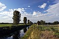
The centre of Somerset is dominated by the Levels, a coastal plain and wetland. The north-east contains part of the Cotswolds uplands and all of the Mendip Hills, which are both national landscapes; the west contains the Quantock Hills and part of the Blackdown Hills, which are also national landscapes, and most of Exmoor, a national park. The major rivers of the county are the Avon, which flows through Bath and then Bristol, and the Axe, Brue, and Parrett, which drain the Levels.
There is evidence of Paleolithic human occupation in Somerset, and the area was subsequently settled by the Celts, Romans and Anglo-Saxons. The county played a significant part in Alfred the Great's rise to power, and later the English Civil War and the Monmouth Rebellion. In the later medieval period its wealth allowed its monasteries and parish churches to be rebuilt in grand style; Glastonbury Abbey was particularly important, and claimed to house the tomb of King Arthur and Guinevere. The city of Bath is famous for its Georgian architecture, and is a UNESCO World Heritage Site. The county is also the location of Glastonbury Festival, one of the UK's major music festivals. (Full article...)
Selected article

A feature of the canal was the variety of methods used at Combe Hay to overcome height differences between the upper and lower reaches of the canal, initially by the use of caisson locks and when this failed an inclined plane and then a flight of 22 locks.
The Radstock arm was never commercially successful and was replaced first with a tramway in 1815 and later incorporated into the Somerset and Dorset Joint Railway. The Paulton route flourished for some years until the coming of the railway and closed in 1898. Much of the course of the canal has since been used for a railway. In October 2006 a grant was obtained from the Heritage Lottery Fund to carry out a technical study on one of the locks and associated structures at Combe Hay. (Full article...)
Selected biography -

Marcus Edward Trescothick OBE (born 25 December 1975) is an English former cricketer who played first-class cricket for Somerset County Cricket Club, and represented England in 76 Test matches and 123 One Day Internationals. He was Somerset captain from 2010 to 2016 and temporary England captain for several Tests and ODIs. Since retirement he has commentated and coached at both county and international level.
A left-handed opening batsman, he made his first-class debut for Somerset in 1993 and quickly established himself as a regular member of the team. Trescothick made his One Day International (ODI) debut seven years later, against Zimbabwe in July 2000. His Test debut, against the West Indies, followed in August. Although former England captain Nasser Hussain likened Trescothick's build and batting temperament to that of Graham Gooch, his stroke play is more reminiscent of David Gower. (Full article...)Districts of Somerset

- Somerset (Unitary)
- North Somerset (Unitary)
- Bath and North East Somerset (Unitary)
Subcategories

Related portals
Selected images
-
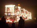 "Samurai" by Griffens CC, at Burnham on Sea Carnival 2006, part of the West Country Carnival circuit (from Culture of Somerset)
 -
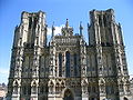 The west front of Wells Cathedral (from Culture of Somerset)
 -
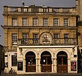
 Brewhouse Theatre, Taunton (from Culture of Somerset)
 -
 The flag designed to represent the historic county of Somerset in 2013 (from Somerset)
 -
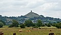 Glastonbury Tor (from Culture of Somerset)
 -
-
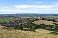 The town of Glastonbury looking west from the top of Glastonbury Tor. The fields in the distance are the Somerset Levels. (from Somerset)
 -
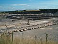 Stone quarries are still a major employer in Somerset (from Somerset)
 -
The west front of Wells Cathedral (from Somerset)
-
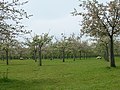 A traditional cider apple orchard at Over Stratton, with sheep grazing (from Somerset)
 -
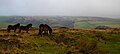 The Exmoor landscape with the native Exmoor Pony (from Somerset)
 -
-
 Bristol Airport, which is located in North Somerset (from Somerset)
 -
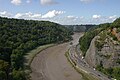 The Avon Gorge, the historic boundary between Gloucestershire and Somerset, and also Mercia and Wessex; Somerset is to the left (from Somerset)
 -
-
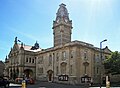 Weston-super-Mare Town Hall, the administrative headquarters of North Somerset (from Somerset)
 -
-
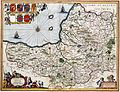 A map of the county in 1646, author unknown (from Somerset)
 -
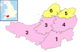 The ceremonial county immediately prior to the 2023 local government restructuring, with South Somerset (1), Somerset West and Taunton (2), Sedgemoor (3) and Mendip (4) as non-metropolitan districts (shown in pink), and just Bath and North East Somerset (5), and North Somerset (6) as unitary authorities (shown in yellow). (from Somerset)
 -
 The Dunster Yarn Market was built in 1609 for the trading of local cloth. (from Somerset)
 -
-
 Brean Down from Steep Holm (from Somerset)
 -
 Sand Sculpture at Weston-super-Mare Sand Sculpture Festival of A Midsummer Nights Dream (from Culture of Somerset)
 -
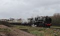 A steam locomotive and carriages, on the West Somerset Railway, a heritage line of notable length, in spring 2015 (from Somerset)
 -
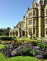 Tyntesfield (from Somerset)
 -
Tyntesfield. (from Culture of Somerset)


.jpg)


_down_South_Wales_Pullman.JPG)

Selected settlement
_from_the_tor_arp.jpg)
Co-ordinates 51°08′55″N 2°42′50″W / 51.1485°N 2.714°W
Glastonbury is a small town situated at a dry point on the low lying Somerset Levels, 30 miles (48 km) south of Bristol. The town, which is in the Mendip district, had a population of 8,784 in the 2001 census. Glastonbury is less than 1 mile (2 km) across the River Brue from the village of Street. Evidence from timber trackways such as the Sweet Track show that the town has been inhabited since Neolithic times. Glastonbury Lake Village was an Iron Age village, close to the old course of the River Brue and Sharpham Park approximately 2 miles (3.2 km) west of Glastonbury, dates back to the Bronze Age. Centwine was the first Saxon patron of Glastonbury Abbey, which dominated the town for the next 700 years. One of the most important abbeys in England, it was the site of Edmund Ironside's coronation as King of England in 1016. Many of the oldest surviving buildings in the town, including the Tribunal, George Hotel and Pilgrims' Inn and the Somerset Rural Life Museum, which is based in an old tithe barn, are associated with the abbey. The Church of St John the Baptist dates from the 15th century.
The town became a centre for commerce, which led to the construction of the market cross, Glastonbury Canal and the Glastonbury and Street railway station, the largest station on the original Somerset and Dorset Joint Railway. The Brue Valley Living Landscape is a conservation project managed by the Somerset Wildlife Trust and nearby is the Ham Wall National Nature Reserve.
Glastonbury has been described as a New Age community which attracts people with New Age beliefs, and is notable for myths and legends often related to Glastonbury Tor, concerning Joseph of Arimathea, the Holy Grail and King Arthur. In some Arthurian literature Glastonbury is identified with the legendary island of Avalon. Joseph is said to have arrived in Glastonbury and stuck his staff into the ground, when it flowered miraculously into the Glastonbury Thorn. The presence of a landscape zodiac around the town has been suggested, along with a collection of ley lines, but no evidence has been discovered. Glastonbury Festival takes its name from the town but is actually held in the nearby village of Pilton. (Full article...)
Did you know...
From Wikipedia's "Did You Know" archives:

- ... that during World War II, Shepton Mallet (pictured), the oldest operating prison in Britain, was used as the protective storage of important government documents including the Magna Carta and Domesday Book?
- ... that the Shapwick Hoard, found by metal detecting cousins in 1998, contained the largest number of silver denarii ever found in Great Britain and was equivalent to ten years' pay for a Roman legionary?
- ... that the village of Sharpham in Somerset, is the birthplace of Elizabethan poet Sir Edward Dyer, writer Henry Fielding and cleric William Gould?
- ... that Simonsbath House was the only house in the Royal Forest of Exmoor for 150 years?
- ... that the only working, full sized, Caisson lock ever built, was on the Somerset Coal Canal at Combe Hay, Somerset in England between 1795 and 1805?
Things you can do
 |
Here are some tasks awaiting attention:
|
WikiProjects
Nearby projects: WikiProject Bristol, WikiProject Devon, WikiProject Dorset, WikiProject Wiltshire
Topics
Recognised content
| This is a list of recognized content, updated weekly by JL-Bot (talk · contribs) (typically on Saturdays). There is no need to edit the list yourself. If an article is missing from the list, make sure it is tagged (e.g. {{WikiProject Somerset}}) or categorized correctly and wait for the next update. See WP:RECOG for configuration options. |
Featured articles
 Ælfheah of Canterbury
- Bath, Somerset
- Battle of Babylon Hill
- Battle of Marshall's Elm
- Margaret Bondfield
- Robert Burnell
- Chew Stoke
- Equestrian statue of Edward Horner
- Exmoor
- Ham Wall
- Herbie Hewett
- Kennet and Avon Canal
- Mells War Memorial
- Mendip Hills
- Lionel Palairet
- Porlock Stone Circle
- River Parrett
- Sieges of Taunton
- Somerset County Cricket Club in 1891
- Somerset County Cricket Club in 2009
- Somerset Levels
- Sweet Track
- Marcus Trescothick
- Wells Cathedral
- Withypool Stone Circle
Featured lists
- List of ecclesiastical parishes in the Diocese of Bath and Wells
- Works of Keith Floyd
- Grade I listed buildings in Bath and North East Somerset
- Grade I listed buildings in Mendip
- Grade I listed buildings in North Somerset
- Grade I listed buildings in Sedgemoor
- Grade I listed buildings in South Somerset
- Grade I listed buildings in Taunton Deane
- Grade I listed buildings in West Somerset
- Grade II* listed buildings in North Somerset
- List of civil parishes in Somerset
- List of English Heritage properties in Somerset
- List of locks on the Kennet and Avon Canal
- List of Sites of Special Scientific Interest in Avon
- List of Sites of Special Scientific Interest in Somerset
- List of Somerset County Cricket Club Twenty20 players
- List of Somerset County Cricket Club grounds
- List of Somerset County Cricket Club players with 100 or more first-class or List A appearances
- List of churches preserved by the Churches Conservation Trust in Southwest England
- List of hillforts and ancient settlements in Somerset
- List of local nature reserves in Somerset
- List of scheduled monuments in North Somerset
- List of scheduled monuments in Sedgemoor
- List of scheduled monuments in South Somerset
- Grade II* listed buildings in Mendip
- List of museums in Somerset
- List of national nature reserves in Somerset
- List of National Trust properties in Somerset
- Scheduled monuments in Bath and North East Somerset
- Scheduled monuments in Mendip
- Scheduled monuments in Taunton Deane
- Scheduled monuments in West Somerset
- Grade II* listed buildings in Sedgemoor
- Grade II* listed buildings in Taunton Deane
- Grade II* listed buildings in West Somerset
Featured topics
Good articles
 A303 road
- 1754 Taunton by-election
- 1887 Taunton by-election
- The Abbot's Fish House, Meare
- Agapemonites
- William Arnold (settler)
- Ashton Court
- Ashton Court Festival
- Athelm
- River Avon, Bristol
- Avon Gorge
- Herbert E. Balch
- Barrington Court
- E. W. Bastard
- Bath Abbey
- Bath Assembly Rooms
- Beckford's Tower
- Berhtwald
- Birnbeck Pier
- Bishop's Palace, Wells
- Blackdown Hills National Landscape
- Blagdon Lake
- John Braham (RAF officer)
- Brean Down
- HMS Bridgewater (L01)
- Bridgwater and Taunton Canal
- Bridgwater Bay
- Bridgwater
- Brislington House
- Bruton Dovecote
- Buildings and architecture of Bath
- Burnham-on-Sea
- Mike Burns (cricketer)
- Buro Happold
- Burrow Mump
- Burton Pynsent House
- Jenson Button
- Allegra Byron
- Cadbury Camp
- Cadbury Castle, Somerset
- Chard, Somerset
- Cheddar Gorge
- Cheddar, Somerset
- Chew Magna
- St Andrew's Church, Chew Stoke
- Claverton Pumping Station
- Cleeve Abbey
- Clevedon
- Clevedon Court
- Clevedon Pier
- Cleveland Pools
- Clifton Suspension Bridge
- Climate of south-west England
- Coleridge Cottage
- The Crescent, Taunton
- Crewkerne
- Cricket at the 1900 Summer Olympics
- Crook Peak to Shute Shelve Hill
- Dolebury Warren
- Dovecot at Blackford Farm
- Dunkery Hill
- Dunstan
- Dunster Butter Cross
- Dunster Castle
- Dunster
- Dunster Working Watermill
- Ebbor Gorge
- Exmoor pony
- Farleigh Hungerford Castle
- Reginald Fitz Jocelin
- Savaric FitzGeldewin
- Henry Fownes Luttrell (died 1780)
- Henry Fox (sportsman)
- Frome
- Fyne Court
- Gallox Bridge, Dunster
- Edith Garrud
- Geography of Somerset
- Geology of Somerset
- Gisa (bishop of Wells)
- Eleanor Glanville
- Glastonbury Abbey
- Glastonbury Canal
- Glastonbury Festival
- Glastonbury
- Glastonbury Lake Village
- Glastonbury Tor
- Grade I listed buildings in Somerset
- Grand Western Canal
- HM Prison Shepton Mallet
- Hestercombe House
- James Hill (British Army officer)
- Sidney Hill
- History of Somerset
- Holnicote Estate
- Hot Fuzz
- Jocelin of Wells
- John of Tours
- Keynsham
- King Alfred's Tower
- King John's Hunting Lodge, Axbridge
- Scott Laird
- Leigh Court
- Leigh Woods National Nature Reserve
- Long Ashton railway station
- Lyfing (archbishop of Canterbury)
- Lytes Cary
- Masonic Hall, Taunton
- Midsomer Norton
- Minehead
- Monmouth Rebellion
- Montacute House
- Muchelney Abbey
- Nailsea Court
- Nailsea
- Nailsea and Backwell railway station
- Nettlecombe Court
- Stephen Newton
- Tom Nichols (footballer)
- Nunney Castle
- Pill railway station
- PinkPantheress
- Portishead, Somerset
- Massey Poyntz
- The Priest's House, Muchelney
- Prior Park Landscape Garden
- Prior Park
- Pulteney Bridge
- Quantock Hills
- Radstock
- River Brue
- River Tone
- Robert of Bath
- Roman Baths (Bath)
- Royal Crescent
- Ted Sainsbury
- St Catherine's Court
- Sand Point and Middle Hope
- Scheduled monuments in Somerset
- Jake Seamer
- Shepton Mallet
- Sigeric (bishop)
- Sir Bevil Grenville's Monument
- Solsbury Hill
- Somerset Coal Canal
- Somerset Coalfield
- Somerset County Cricket Club in 1882
- Somerset County Cricket Club in 1885
- Somerton, Somerset
- Stanton Drew stone circles
- Steep Holm
- Stembridge Mill, High Ham
- Stoke sub Hamdon Priory
- Ston Easton Park
- Stoney Littleton Long Barrow
- Street, Somerset
- Sutton Court
- Sydney Gardens
- St Joseph's Convent, Taunton
- Taunton
- Taunton Unitarian Chapel
- Team Bath F.C.
- Theatre Royal, Bath
- Tintinhull Garden
- To Catch a Copper
- Treasurer's House, Martock
- Hugh Trenchard, 1st Viscount Trenchard
- The Tribunal, Glastonbury
- Tyntesfield
- Vicars' Close, Wells
- Walton and Ivythorn Hills
- Watchet
- Wellington Monument, Somerset
- Wellington, Somerset
- Hugh of Wells
- Wells, Somerset
- West Hendford Cricket Ground
- West Pennard Court Barn
- West Somerset Mineral Railway
- Westhay Moor
- Weston-super-Mare
- Westonzoyland Pumping Station Museum
- Edward Wickham
- Maisie Williams
- Woodspring Priory
- Wookey Hole Caves
- Worle railway station
- Worlebury Camp
- Wulfhelm
- Yarn Market, Dunster
- Yatton railway station
- Yeovil
Good topics
Associated Wikimedia
The following Wikimedia Foundation sister projects provide more on this subject:
-
 Commons
Free media repository -
 Wikibooks
Free textbooks and manuals -
 Wikidata
Free knowledge base -
 Wikinews
Free-content news -
 Wikiquote
Collection of quotations -
 Wikisource
Free-content library -
 Wikiversity
Free learning tools -
 Wikivoyage
Free travel guide -
 Wiktionary
Dictionary and thesaurus


