
Wikipedia:Graphics Lab/Map workshop/Archive/Jul 2024
| This is an archive of past discussions for the period 2023. Do not edit the contents of this page. If you wish to start a new discussion or revive an old one, please do so on the current main page. |
 | Archives of 2023: January, February, March, April, May, June, July, August, September, October, November, December |
Change to postcode map
-
 Original

- Article(s)
- Postal code
- Request
- Is it possible to make the United states striped in the colors for 5 and 9? Both lengths of ZIP codes are commonly used in the US. Some other countries on the map have different length postcodes as well but only for certain regions or special purposes while in the US one can basically choose which one to use. -- 188.23.202.105 (talk) 17:20, 6 July 2024 (UTC)
- Discussion
-
- The image description page says Maximum possible length of a complete postal code is shown. Seems to me it should remain marked as 9 only. Nyttend (talk) 11:46, 7 July 2024 (UTC)
Distribution of Nepali speakers in India 2011
- Article(s)
- Nepali language
- Request
- Can you make a svg map of Distribution of Nepali speakers in India with this data atlas. Include only 5.01 - 20.00 and 20.01 and Above percentage. Thanks. (page 53; map 24) -- बडा काजी (talk) 08:00, 10 July 2024 (UTC)
- Discussion
1901 Boston Marathon course map
-
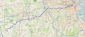 Route of the 2013 Boston Marathon

- Article(s)
- 1901 Boston Marathon
- Request
- Requesting a course / route map of the 1901 Boston Marathon. Example map for the 2013 Boston Marathon can be found at File:Boston Marathon route.png. The official description of the route can be found in the background section, but an editor helpfully explained it in modern-day terms with links to relevant landmarks here: Talk:1901 Boston Marathon#c-Editør-20240710064100-Editør-20240709201400. Any assistance would be greatly appreciated. -- Habst (talk) 12:17, 10 July 2024 (UTC)
- Discussion
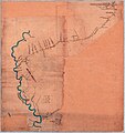
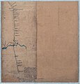
Natchez District/Old Natchez Trace locations
-
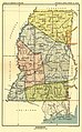 1. Possibly helpful old reference map (1898) - his understanding of Natchez District is region 43 bottom left
 -
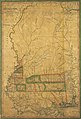 2. Possibly helpful old reference map (1820)
 -
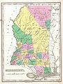 3. Possibly helpful old reference map (1827)
 -
 ON EDIT - never mind unless someone wound find this fun - I found the original survey so I'm going to use that! - A Survey of the Route, proposed for the high way from Nashville in the State of Tenessee, to the Grind stone ford of the Bayou Pierre in the Mississippi Territory
 -
 ON EDIT - original survey, part 2, Tennessee River section.


- Article(s)
- Natchez District, Andrew Jackson and the slave trade in the United States
- Request
- Hello! I'm hoping to create a map of the colonial/territorial Natchez District of Mississippi to go with Andrew Jackson and the slave trade in the United States (and maybe Robards–Donelson–Jackson relationship controversy). The Natchez District was roughly where Warren, Claiborne, Jefferson, Adams, Franklin, Wilkinson, and Amite counties are today. The region was mapped intensely during the American Civil War but by then a lot of the colonial/territorial/Natchez Trace places were already shambling ruins so they don't appear or don't quite convey the historical geography. I'm also trying to convey a sense that in the 1788–1812 era this was very wide open, unsurveyed land that was still more Indigenous than colonized (leading to Andrew Jackson's later key role in Indian Removal), etc.
KEY HUMAN SETTLEMENTS
- Natchez - GNIS 0691586
- Old Greenville - GNIS 1782013
- Bruinsburg - GNIS 691732
- Washington - GNIS 679358
- Port Gibson (south fork of Bayou Pierre) - GNIS 0676254
- Grindstone Ford (north fork of Bayou Pierre) - 32.002778, -90.896111
- Fort Adams - GNIS 670108
- Petit Gulf (name changed from Petit Gulf to Rodney in 1828) - GNIS 676809
- Grand Gulf - GNIS 670578
- Walnut Hills (name changed from Walnut Hills to Vicksburg in 1825) - 0679216
KEY GEOGRAPHIC FEATURES
- Mississippi River
- Big Black River
- Bayou Pierre
- Coles Creek
- Fairchild Creek
- St. Catherines Creek
- Homochitto River
- 31st parallel
- Bayou Sara
The Mississippi River and other watercourses have very rudely moved many times since these places were settled (Rodney is now 3 miles inland etc), so it is messy overlaying these ghost towns on a current map but oh well.
Other possible map sources:
- https://stars.library.ucf.edu/fhq/vol74/iss4/4 - page 4
- https://repository.lsu.edu/gradschool_theses/2133 - page 5
Please let me know if you have questions!! -- jengod (talk) 19:22, 27 August 2024 (UTC)
- Discussion
{{resolved}} - While trying to find you more reference maps I found the original survey for the Trace which pretty much covers all of the above requested!
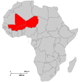
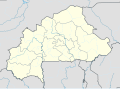
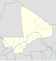
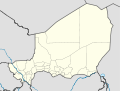
Request: Combined location map for Mali, Burkina Faso, and Niger
-
-
-
-
-
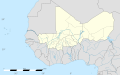 New map with adjoining Module


- Article(s)
- Islamist insurgency in the Sahel
- Request
- I am requesting a location map for Mali, Burkina Faso, and Niger combined with first level admin borders. This request is due to the three countries being most severely affected by the same insurgent groups which frequently operate in all three countries, along with the three countries integrating closer together in an alliance to act as a counter to ECOWAS -- TheMapLurker (talk) 05:11, 13 July 2024 (UTC)
- Discussion
- @TheMapLurker:
 Done TheWanderingTraders (talk) 22:16, 13 July 2024 (UTC)
- THANK YOU
- But would it be too much effort to ask for first level admin borders for the new map? TheMapLurker (talk) 17:14, 14 July 2024 (UTC)
- Done, Sorry for the delay. TheWanderingTraders (talk) 21:43, 5 August 2024 (UTC)
- @TheMapLurker: TheWanderingTraders (talk) 21:43, 5 August 2024 (UTC)
- Marking as {{resolved}}
- @TheMapLurker: TheWanderingTraders (talk) 21:43, 5 August 2024 (UTC)
Combined map for Malayo-Polynesian groups and Indonesia Ethnic Groups Map


- Article(s)
- Ethnic groups in Indonesia
- Request
- Pleas add boundary of language group from first map to second map.
- Discussion