This is an archive of past discussions on Wikipedia:Graphics Lab, for the period 2023. Do not edit the contents of this page. If you wish to start a new discussion or revive an old one, please do so on the current main page.
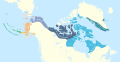
there are no maps in wikipedia of this region and time period and countries like yemen, saudi, transjordan, Mahra, Dhofar, Kathiri and, Quaiti don't have maps like this one on wikipedia/commons.
Create a map depicting all of the Mikkeller locations for inclusion in the named article. There is a large density in Copenhagen, so I am unsure of the best way to depict that. Perhaps two maps? Locations are located at: https://www.mikkeller.com/locations.
Need a track map of the storm based on this article using the same intervals (6 hours). Ideally it should be in the same style as other WP:WPTC/Tracks although considering that WPTC tracks are based on wind speed and the source listed has none, it would be fine if it wasn't in the same style. -- RandomInfinity17 (talk - contributions) 23:53, 10 October 2023 (UTC)
The main reason why I put this request here is because a), the WPTC track maps are based on wind speed, not pressure and (more importantly) b), WPTC track maps need coordinate input, and the source for the track has no coordinates. I mostly retract my statement that it should be in WP:WPTC/Tracks style as I didn't realize it need coordinates. RandomInfinity17 (talk - contributions) 22:59, 16 October 2023 (UTC)
Hi, I'm looking for a map of the Province of Canada, which existed from 1841 to 1867. Wikimedia Commons has some maps contemporary to that time, but they're all brown/sepia, and detailed, so hard to read on a computer. The Province of Canada consisted of the merger of Lower Canada (as it existed in 1841) and Upper Canada. This map:
is similar to what it should look like, but without Labrador, as that had been transferred to Newfoundland in the early 19th century. If the map could also just focus on the Province of Canada, and not all of upper North America, that would be great. I don't know if it would be possible to put the five main cities on it? Quebec City, Montreal, Kingston, Toronto, and Ottawa? Thanks! -- Mr Serjeant Buzfuz (talk) 20:01, 11 October 2023 (UTC)
In the source I'm leaving below, there are two maps (on pages 3 and 4 of the PDF) for the area Zayn al-Din Qaraja and Ghars al-Din Khalil were most "active" in (according to the caption; i. e. the region they controlled at some point). I currently lack the necessary skills or softwares to create a good map. I would greatly appreciate if anyone could either create two maps based on the ones found in the source or give me some tips (best softwares to use, etc.). The source:
Alıç, Samet (2020). "Memlûkler Tarafından Katledilen Dulkadir Emirleri" [The Dulkadir's Emirs Killed by the Mamluks]. The Journal of Selcuk University Social Sciences Institute (in Turkish) (43): 83–94. Retrieved 19 March 2023.


 Map that needs correction.
 Done TheWanderingTraders (talk) 07:33, 4 December 2023 (UTC) Hope this helps, first map I've made.
