Sonagazi Upazila
Sonagazi
সোনাগাজী | |
|---|---|
 | |
| Coordinates (Sonagazi upazila parishad): 22°51′27.44683″N 91°23′44.02031″E / 22.8576241194°N 91.3955611972°E | |
| Country | |
| Division | Chittagong |
| District | Feni |
| Seat | Sonagazi |
| Government | |
| • Upazila parishad chairman | Jahir Uddin Mahmud ( AL) |
| • Upazila Nirbahi Officer | Kamrul Hasan |
| Area | |
• Total | 284.9 km2 (110.0 sq mi) |
| Population | |
• Total | 290,667 |
| • Density | 1,000/km2 (2,600/sq mi) |
| Time zone | UTC+6 (Bangladesh Standard Time) |
| Postal code | 3930[2] |
| Area code | 0331[3] |
| Website | Official Website of Sonagazi Upazila |
Sonagazi (Bengali: সোনাগাজী) is an upazila (sub-district) of Feni District in Chittagong Division, Bangladesh, located on the coast of the Bay of Bengal.
At the 2022 census, its population was 290 thousand, making it the second most populous upazila in Feni District. The upazila comprises one municipality and nine union councils.
History
[edit]Etymology
[edit]Legend has it that Sona Ghazi Bhuyan, a notable figure from the Ghazi family of landowners belonging to the Baro-Bhuyan confederacy, played a pivotal role in developing a market for salt trade in the coastal area. The name Sonagazi was selected for the thana established with the market at its center.[4]: 147
Mughal period
[edit]Upon his accession to the throne, Mughal Emperor Shah Jahan appointed his son, Shah Shuja, as the subahdar (governor) of Bengal. Upon assuming this role, Shuja swiftly took action to safeguard the coastal areas from Arakanese naval attacks by constructing a fort in Sonagazi among various strategic initiatives. The area surrounding the fort continues to be known as Sujapur in his honor.[5]: 111–112
Establishment of thana
[edit]When the Mughal era-established thanas (police jurisdictions) of Jugidiya and Amirgaon in the then Bhulua region of Noakhali near the coast of the Bay of Bengal were submerged by the Feni River, a new thana named Sonagazi was established in 1886 to reinstate law enforcement measures in the southern region of Feni.[4]: 147 Around this period, the governor of Feni mahakuma, Nabinchandra Sen, undertook the construction and improvement of the Feni–Sonagazi road to accommodate bullock carts.[5]: 52
Liberation war–present day
[edit]Around the time of the Bangladesh Liberation War, Sonagazi was one of the four thanas within the Feni mahakuma, alongside Feni Sadar, Chhagalnaiya, and Parshuram.[5]: 25 During the conflict, guerrilla warfare-trained freedom fighters were dispatched to various areas of Sonagazi, where they carried out numerous operations targeting the residences of collaborators of the invading forces and local razakar militias in locations such as Nababpur, Ahammadpur, Majlishpur, Bogadana, Char Darbesh, Char Chandia, and Motiganj.[5]: 80–81
On 28 July 1971, during a confrontation between freedom fighters and the Pakistani army at Nababpur, an enemy military commander was killed. On 15 August, approximately 50 Pakistani soldiers were killed when mines planted by the freedom fighters exploded near the Satbaria Bridge. In retaliation, agitated Pakistani soldiers killed five innocent individuals from Boks Ali and Sujapur Dasgram villages. Additionally, the Pakistani army engaged in looting and set fire to numerous houses in the area.[6]
Following the war, mass graves were uncovered in areas like the Kazir Haat sluice gate, indicating the burial of hundreds of individuals who had been subjected to torture,[5]: 91 and memorial monuments were erected at eight locations within the upazila.[6]
In 1983, Sonagazi Thana was upgraded to the status of an upazila,[6] one year before Feni was established as a district.[4]: 190
Geography
[edit]
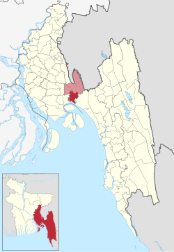
Sonagazi Upazila is bounded by Feni Sadar and Daganbhuiyan upazilas on the north, Bay of Bengal on the south, Mirsharai Upazila on the east, and Companiganj Upazila of Noakhali District and Daganbhuiyan Upazila on the west. Situated in the southern part of the district, Sonagazi is the only upazila in Feni District with a coastline along the Bay of Bengal.[6] It covers a total area of 284.89 square kilometres (110.00 sq mi), making it the largest upazila in Feni District, accounting for almost 28.77% of the district's total area.[7]
Physical geography
[edit]The Feni River flows to the east of Sonagazi, while the Little Feni River flows to the west. The estuaries of both rivers converge in the Bay of Bengal, south of Sonagazi.[5]: 34 Extensive alluvial lands, known locally as "char," have formed due to the erosion caused by the Feni and Muhuri rivers, resulting in the displacement of numerous settlements. Examples of such areas include Char Chandia, Char Khondkar, and Char Narayan.[5]: 35
Governance and politics
[edit]Jahir Uddin Mahmud is the presently elected upazila council (upazila parishad) chairman of Sonagazi Upazila[8] and Kamrul Hasan the appointed upazila executive officer (upazila nirbahi officer or UNO).[9] The upazila is encompassed by the Feni-3 constituency of the Jatiya Sangsad (national parliament).[10]
Unions
[edit]Sonagazi Upazila comprises nine unions, each administered by its respective union council (union parishads), which includes a chairman and 12 elected ward councillors. The general councillors represent their nine respective wards, with three additional reserved seats for women on the council. Cumulatively, the unions comprise a total of 94 mauzas and 95 villages.[11]
| Number | Name | Area (in acres) | Area (in km2) | Population (2022) |
|---|---|---|---|---|
| 1 | Char Majlishpur | 4,331 acres | 17.53 km2 | 30,265 |
| 2 | Bogadana | 3,337 acres | 13.50 km2 | 25,964 |
| 3 | Mangalkandi | 3,156 acres | 12.77 km2 | 24,476 |
| 4 | Motigonj | 3,364 acres | 13.61 km2 | 28,843 |
| 5 | Char Dorbesh | 12,171 acres | 49.25 km2 | 37,899 |
| 6 | Char Chandia | 14,271 acres | 57.75 km2 | 45,215 |
| 7 | Sonagazi | 11,008 acres | 44.55 km2 | 22,640 |
| 8 | Amirabad | 10,921 acres | 44.20 km2 | 30,805 |
| 9 | Nababpur | 6,523 acres | 26.40 km2 | 19,754 |
Char Chandia is the largest and most populous union, whereas Mangalkandi is the smallest in size. Nonetheless, Nababpur Union has the smallest population.[12][13]
Municipality
[edit]Sonagazi Upazila contains one municipality, Sonagazi Municipality (also Sonagazi Paurashava, Bengali: সোনাগাজী পৌরসভা), established in 2002 and spanning an area of 5.04 square kilometres (1.95 sq mi).[11][14] At the 2022 census, it had a population of 24,808 residents.[15] The municipality is bordered by Motigonj Union to the north, Sonagazi Union to the east, and Char Chandia Union to the west and south. It comprises nine numbered wards, encompassing six villages, seven mauzas and 14 mahallas.[14][11] Rafiqul Islam Khokan serves as the municipal mayor, elected in the 2021 municipal elections. Each ward is represented by a councillor, with an additional three seats allocated for female councillors.[16]
Demographics
[edit]As of the 2022 Census of Bangladesh, Sonagazi Upazila has 67,320 households and a population of 290,664 with an average 4.28 people per household, standing as the second most populous upazila in Feni District behind Feni Sadar Upazila. The upazila has the lowest literacy rate among 7 years and above in Feni District, an average of 75.84%, compared to the national average of 74.8%. There are 1158 females for 1000 males.[15]
Sonagazi Municipality has a total population of 24,808 and a literacy rate of 81.11%.[15]
Religion
[edit]According to the 2022 census, religious groups in Sonagazi Upazila included:[17]: 54
- Islam (275,116)
- Hinduism (15,382)
- Christianity (15)
- Buddhism (146)
- Other (8)
Since 2011, the populations of Muslims and Buddhists have increased, whereas the numbers for other religious groups have decreased.[11]: 14
Language
[edit]The language spoken in Sonagazi Upazila shares core characteristics with other upazilas in Bangladesh, but some variations exist. Notably, aspirated consonants are less prevalent in spoken language, suggesting a trend towards linguistic simplification. The regional dialect of Sonagazi Upazila shows similarities to languages spoken in Feni, Noakhali, and Mirsarai. Experts attribute these linguistic features to the geographical influence of the Little Feni and Feni rivers, as well as the coastal environment of Sonagazi.[18]
Economy
[edit]Agriculture constitutes a significant portion of the sources of income for Sonagazi, contributing approximately 36.40% to the economy.[6] The primary crop cultivated in the upazila is rice (paddy).[11]: 17
Other major sources of income include commerce (12.67%), services (15.62%), rent and remittance (14.04%), and various other activities such as non-agricultural labor (3.35%), industry (1.58%), transport and communication (4.40%), construction (2.11%), and religious services (0.56%).[6] Some important marketplaces in Sonagazi include Kuthirhaat, Boktarmunshi Bazar, Mongolkandi, Olama Bazar, Saudagar Haat, Bhairab Chowdhury Bazar, Mongazi Bazar, Sonagazi Bazar, Amirabad Bazar, Nababpur, Bhorbazar, Kazir Haat, Naar Miar Haat, Bagher Haat, Koramia Haat, Motiganj Bazar, Kashmir Bazar etc.[5]: 41
In the coastal "char" areas surrounding the expansive Feni River, agriculture, fish farming, and harvesting marine fish from the river constitute the primary livelihood sources for the local populace. Additionally, residents engage in raising cattle, buffaloes, and sheep in the grazing lands. Buffalo milk and cow's milk from these areas are distributed to other regions. The grazing lands are renowned for the production of buffalo milk and yogurt. Residents of the grazing lands typically reside in tin houses. However, their daily lives are often disrupted by raids and attacks by pirates, posing risks to fishermen and livestock keepers alike. Law enforcement agencies conduct periodic raids in response to these incidents.[5]: 35
Due to its heavy reliance on agriculture, Sonagazi Upazila has witnessed the emergence of artisans specializing in crafting tools from bamboo and canes for agricultural and household needs. These artisans produce a variety of baskets in different sizes and shapes, suitable for carrying items ranging from fish and crops to laundry.[5]: 121 In numerous villages, young women engage in crafting woven handicrafts using jute leaves and jute fiber, employing skills inherited through generations. These handcrafted items are then sold in nearby markets.[5]: 125–126
Infrastructure
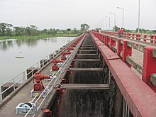
[edit]Sonagazi is renowned for its sluice gate referred to as Muhuri Irrigation Project. Constructed in the late 1980s, this infrastructure serves the purpose of regulating the water flow of the Feni River and irrigating nearby farmland. Later in 2005, a now-defunct 900-kilowatt wind power plant consisting of four wind turbines was constructed near the river. The area has garnered attention as a notable tourist destination in the region.[4][19][20]
Sonagazi currently hosts a solar farm generating 75 megawatts of power, with additional plans underway to establish more.[21][22] Additionally, there are proposals for the constructions of several more wind and combined-cycle power stations to meet the rising energy demand of the nearby Bangabandhu Sheikh Mujib Shilpa Nagar economic zone.[19][23]
In 2018, a highly anticipated 478-metre-long (1,568 ft) bridge spanning the Little Feni River was inaugurated with the aim of improving connectivity with Noakhali and Lakshmipur districts.[24]
Muhuri Irrigation Project
[edit]The Muhuri Irrigation Project completed in 1986 stands as the nation's second-largest irrigation venture. Its primary objectives include regulating flooding during the monsoon season and provide supplementary irrigation for rice cultivation in most of Feni District including Sonagazi Upazila. The project features a closure dam located in Sonagazi Upazila tasked with regulating the combined flow of the Feni, Muhuri, and Kalidas-Pahalia rivers.[5]: 37
Over the years, Muhuri Irrigation Project area has emerged as a popular recreation and picnic spot. During the winter season, tourists from various parts of the country visit the area. The dam is surrounded by an artificial water body enclosed by embankments, afforestation, bird-watching spots, and fish sanctuaries. During boat rides on the river, visitors can observe various species of ducks and thousands of birds belonging to various species.[5]: 38
Transportation and communication
[edit]Sonagazi is located 26 kilometres (16 mi) from Feni District headquarters.[11]: 17 CNG-powered auto-rickshaws, electric rickshaws, and minibuses constitute the primary modes of transportation.[5]: 35 As of 2011, Sonagazi Upazila had two bus stops and a network of roads spanning a total distance of 520 kilometres (320 mi).[11]: 67
Schools and colleges
[edit]- Al-Helal Academy Sonagazi
- Sonagazi Government College
- Sonagazi Girls' Pilot High School
- Bakter Munshi High School
- Sonagazi Islamia Fazil Degree Madrasah
Notable people
[edit]- Zahir Raihan, filmmaker, was born at Majupur village in 1935.[25]
- Shahidullah Kaiser, writer, was born at Majupur village in 1927.[26]
- Selim Al Deen, playwright, was born at Shenerkhil village in 1949.[27]
- Lt. Gen. Masud Uddin Chowdhury, ndc, psc, MP and Diplomat[citation needed]
- Shomi Kaiser, actress[citation needed]
- Rokeya Prachy, actress[28]
- Mahbubul Alam Tara was the Member of Parliament from constituency Feni-3 from 1991 until 1996.[29]
See also
[edit]References
[edit]- ^ National Report (PDF). Population and Housing Census 2022. Vol. 1. Dhaka: Bangladesh Bureau of Statistics. November 2023. p. 397. ISBN 978-9844752016.
- ^ "Bangladesh Postal Code". Dhaka: Bangladesh Postal Department under the Department of Posts and Telecommunications of the Ministry of Posts, Telecommunications and Information Technology of the People's Republic of Bangladesh. 20 October 2024.
- ^ "Bangladesh Area Code". China: Chahaoba.com. 18 October 2024.
- ^ a b c d Ahmed, Jamir (March 1990). Phenīra itihāsa ফেনীর ইতিহাস [History of Feni] (in Bengali). Chittagong: Samatata Publication. LCCN 91901208. OCLC 25204071.
- ^ a b c d e f g h i j k l m n Khan, Shamsuzzaman; Hossain, Md. Altaf, eds. (June 2014). Bangladesher Lokaja Sangskriti Granthamala বাংলাদেশের লোকজ সংস্কৃতি গ্রন্থমালা [Bangladesh Folk Culture Series]. Present State of Folklore in Feni District (in Bengali). Dhaka: Bangla Academy. ISBN 9840758535.
- ^ a b c d e f Mahin, Mahiuddin Hossain (2023). "Sonagazi Upazila". In Sirajul Islam; Miah, Sajahan; Khanam, Mahfuza; Ahmed, Sabbir (eds.). Banglapedia: the National Encyclopedia of Bangladesh (Online ed.). Dhaka, Bangladesh: Banglapedia Trust, Asiatic Society of Bangladesh. ISBN 984-32-0576-6. OCLC 52727562. OL 30677644M. Retrieved 16 December 2024.
- ^ District Report: Feni (PDF). Agriculture Census 2019. Dhaka: Bangladesh Bureau of Statistics. December 2022. ISBN 9789844751330.
- ^ "সোনাগাজীতে উপজেলা চেয়ারম্যান বিনা প্রতিদ্বন্দ্বিতায় নির্বাচিত" [Sonagazi upazila chairman elected unopposed]. ABNEWS24 (in Bengali). 14 March 2019. Retrieved 26 February 2024.
- ^ "Officer List: Sonagazi Upazila". Bangladesh National Portal. Retrieved 26 February 2024.
- ^ "Feni-3: JaPa candidate served show-cause notice for breaching electoral code". Dhaka Tribune. 5 January 2024. Retrieved 19 March 2024.
- ^ a b c d e f g District Statistics 2011 (PDF). Vol. Feni. Dhaka: Bangladesh Bureau of Statistics. December 2013. ISBN 9789845190459. Archived from the original (PDF) on 20 March 2023.
- ^ a b National Report (PDF). Bangladesh Population and Housing Census 2011. Vol. 2. Dhaka: Bangladesh Bureau of Statistics. March 2014. pp. 149–150. OCLC 946030979. Retrieved 4 May 2024.
- ^ a b Enumerated Population (Provisional) of Feni District (in Bengali and English). Bangladesh Bureau of Statistics. 2022. Retrieved 29 June 2024.
- ^ a b "এক নজরে পৌরসভা: সোনাগাজী উপজেলা" [Municipality at a Glance: Sonagazi Upazila]. Bangladesh National Portal (in Bengali). Retrieved 29 March 2024.
- ^ a b c National Report (PDF). Population and Housing Census 2022. Vol. I. Dhaka: Bangladesh Bureau of Statistics. November 2023. ISBN 9789844752016.
- ^ "সোনাগাজী পৌরসভা নির্বাচনে কাউন্সিলর হলেন যারা" [Councillors elected in the Sonagazi municipal elections]. Daily Amar Sangbad (in Bengali). 20 September 2021. Retrieved 29 March 2024.
- ^ a b District Report: Feni (PDF). Population and Housing Census 2022 (in English and Bengali). Dhaka: Bangladesh Bureau of Statistics. June 2024. ISBN 978-984-475-246-7.
- ^ "ভাষা ও সংষ্কৃতি" [Language and culture]. Bangladesh National Portal. সোনাগাজী উপজেলা, Sonagazi Upazila (in Bengali). Retrieved 3 May 2024.
- ^ a b "Country's first big leap in wind energy from December". The Business Standard. 21 July 2022. Retrieved 27 February 2024.
- ^ "পর্যটনের সম্ভাবনা মিরসরাইয়ের মুহুরী প্রজেক্ট" [Tourism potential of Muhuri project at Mirsarai]. Prothom Alo (in Bengali). 26 August 2023.
- ^ "Another 100MW solar power plant in Feni on the cards". Dhaka Tribune. 3 October 2023.
- ^ "Sonagazi 75MW solar power plant to start generation soon". The Financial Express. Retrieved 27 February 2024.
- ^ "Govt moves for more power plants in Feni to feed economic zones". The Business Standard. 12 September 2023. Retrieved 27 February 2024.
- ^ "সোনাগাজীবাসীর কাংখিত 'ছোট ফেনী নদী সেতু' উদ্বোধন" [Inauguration of the much-awaited Little Feni River Bridge]. ABNEWS24 (in Bengali). 1 November 2018. Retrieved 27 February 2024.
- ^ Khan, Abu Sayeed (2012). "Raihan, Zahir". In Islam, Sirajul; Jamal, Ahmed A. (eds.). Banglapedia: National Encyclopedia of Bangladesh (Second ed.). Asiatic Society of Bangladesh.
- ^ Alam, Muhammad Shamsul (2012). "Kaiser, Shahidullah". In Islam, Sirajul; Jamal, Ahmed A. (eds.). Banglapedia: National Encyclopedia of Bangladesh (Second ed.). Asiatic Society of Bangladesh.
- ^ "Selim Al Deen no more". The Daily Star. 15 January 2008.
- ^ "সব মাধ্যমেই সফল রোকেয়া প্রাচীর পথচলা" [Rokeya Prachy's successful journey across all media]. newsg24.com (in Bengali). 3 April 2023. Retrieved 19 March 2024.
- ^ "List of 5th Parliament Members". Bangladesh Parliament (in Bengali).

