Soltaniyeh County
Appearance
Soltaniyeh County
Persian: شهرستان سلطانیه | |
|---|---|
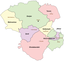
 Location of Soltaniyeh County in Zanjan province (right, yellow) | |
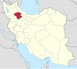
 Location of Zanjan province in Iran | |
| Coordinates: 36°28′N 48°49′E / 36.467°N 48.817°E[1] | |
| Country | |
| Province | Zanjan |
| Capital | Soltaniyeh |
| Districts | Central, Bagh Helli |
| Area | |
• Total | 1,358.8 km2 (524.6 sq mi) |
| Population (2016)[2] | |
• Total | 29,480 |
| • Density | 22/km2 (56/sq mi) |
| Time zone | UTC+3:30 (IRST) |
Soltaniyeh County (Persian: شهرستان سلطانیه) is in Zanjan province, Iran. Its capital is the city of Soltaniyeh. There is a large cave called Katale Khor near the capital city.[3]
History
[edit]After the 2011 National Census, Soltaniyeh District was separated from Abhar County in the establishment of Soltaniyeh County,[4] which was divided into two districts of two rural districts each, with Soltaniyeh as its capital and only city. The village of Guzal Darreh was elevated to the status of a city in 2024.[5]
Demographics
[edit]Population
[edit]At the time of the 2016 census, the county's population was 29,480 in 9,130 households.[2]
Administrative divisions
[edit]Soltaniyeh County's population and administrative structure are shown in the following table.
| Administrative Divisions | 2016[2] |
|---|---|
| Central District | 17,987 |
| Soltaniyeh RD | 2,031 |
| Sonbolabad RD | 8,318 |
| Soltaniyeh (city) | 7,638 |
| Bagh Helli District | 11,493 |
| Guzal Darreh RD | 4,794 |
| Qarah Bolagh RD | 6,699 |
| Guzal Darreh (city)[a] | |
| Total | 29,480 |
| RD = Rural District | |
See also
[edit]![]() Media related to Soltaniyeh County at Wikimedia Commons
Media related to Soltaniyeh County at Wikimedia Commons
Notes
[edit]References
[edit]- ^ OpenStreetMap contributors (10 September 2024). "Soltaniyeh County" (Map). OpenStreetMap (in Persian). Retrieved 10 September 2024.
- ^ a b c Census of the Islamic Republic of Iran, 1395 (2016): Zanjan Province. amar.org.ir (Report) (in Persian). The Statistical Center of Iran. Archived from the original (Excel) on 27 April 2022. Retrieved 19 December 2022.
- ^ "Katale Khnor (English)". Hamyar Zangan Company. Archived from the original on 2 April 2015. Retrieved 26 April 2017.
- ^ "Zanjan became the owner of a new city and county". zanjan.irna.ir (in Persian). 16 May 1392. Archived from the original on 14 October 2013. Retrieved 25 February 2023 – via Islamic Republic News Agency.
- ^ a b "Guzal Darreh turned from a village to a city". mehrnews.com (in Persian). Ministry of the Interior. 2 June 2024. Archived from the original on 3 June 2024. Retrieved 10 September 2024 – via Mehr News Agency.

