Narayanganj
Narayanganj
নারায়ণগঞ্জ | |
|---|---|
|
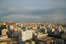
From top: City Skyline, Port of Narayanganj, Tomb of Sultan Ghiyasuddin Azam Shah , Baro-Bhuyan Palace of Lord Isa Khan, Historical Panam City, Hajiganj Fort in City East | |
| Coordinates: 23°37′12″N 90°30′00″E / 23.62000°N 90.50000°E | |
| Country | |
| Division | Dhaka |
| District | Narayanganj |
| Municipal Board | 8 September 1876 |
| Metropolitan city | 5 May 2011 |
| Government | |
| • Type | Mayor–council government |
| • Body | Narayanganj City Corporation |
| • Administrator | A. H. M. Kamruzzaman |
| Area | |
| 33.57 km2 (12.96 sq mi) | |
| • Water | 48.56 km2 (18.75 sq mi) |
| • Metro | 72.43 km2 (27.97 sq mi) |
| Elevation | 3 m (10 ft) |
| Population | |
| 967,951 | |
| • Density | 29,000/km2 (75,000/sq mi) |
| Time zone | UTC+6 (Bangladesh Time) |
| Postal code | 1420 |
| Area code | 0671 |
| Calling Code | 02 |
| Website | ncc |
Narayanganj (Bengali: নারায়ণগঞ্জ, romanized: Narayongônjo) is a city in central Bangladesh in the Greater Dhaka area. It is in the Narayanganj District, about 16 km (10 mi) southeast of the capital city of Dhaka. With a population of almost 1 million, it is the 6th largest city in Bangladesh.[2] It is also a center of business and industry, especially the jute trade and processing plants, and the textile sector of the country. It is nicknamed the Dundee of Bangladesh, due to the presence of its many jute mills. (Dundee was the first industrialised 'Juteopolis' in the world.[3])
History
[edit]The city got its name from Bicon Lal Pandey, a Hindu religious leader who was also known as Benur Thakur or 'Lakshmi Narayan Thakur'. He leased the area from the British East India Company in 1766 following the Battle of Plassey. He donated the markets and the land on the banks of the river as Devottor or 'Given to God' property, bequeathed for maintenance expenses for the worship of the god Narayan.
A post office was set up in 1866, and Dhaka-Narayanganj telegraph service was started in 1877. The Bank of Bengal introduced the first telephone service in 1882.

The Narayanganj Municipality was incorporated on 8 September 1876. The first hospital in the area of Narayanganj Victoria Hospital was established in 1885 by the Municipality with financial contributions from Harakanta Banerjee.[2]
Narayanganj City Corporation was established on 5 May 2011, unifying three former municipalities: Narayanganj Municipality, Siddhirganj Municipality, and Kadam Rasul Municipality.[4] The mayor of Narayanganj City Corporation (NCC) is Selina Hayat Ivy. Prior to this, she was the mayor of Narayanganj Municipality.
Demographics
[edit]According to the 2022 Census of Bangladesh, present-day Narayanganj City Corporation had 255,468 households and a population of 967,951. The average household size was 3.74. Narayanganj had a literacy rate (age 7 and over) of 83.66%, compared to the national average of 74.80%, and a sex ratio of 99.85.[1][5][6]
Narayanganj has four railway stations named Pagla Halt railway station, Fatulla railway station, Chashara railway station and Narayanganj railway station. From Dhaka anyone can use three roads to enter the city: Dhaka–Narayanganj old road, Dhaka–Narayanganj link road and Narayanganj–Demra road. The BRTC AC Bus gives bus transport service from Narayanganj to Dhaka.
See also
[edit]References
[edit]- ^ a b c Population and Housing Census 2022 - District Report: Narayanganj (PDF). District Series. Dhaka: Bangladesh Bureau of Statistics. June 2024. ISBN 978-984-475-281-8.
- ^ a b Solaiman, Md. (2012). "Narayanganj". In Sirajul Islam; Miah, Sajahan; Khanam, Mahfuza; Ahmed, Sabbir (eds.). Banglapedia: the National Encyclopedia of Bangladesh (Online ed.). Dhaka, Bangladesh: Banglapedia Trust, Asiatic Society of Bangladesh. ISBN 984-32-0576-6. OCLC 52727562. OL 30677644M. Retrieved 19 December 2024.
- ^ "Jute Industry in Dundee and India". Dundee (UK). Archived from the original on 2017-04-15. Retrieved 2017-12-20.
- ^ "History of Narayanganj City Corporation". Bangladesh National Portal. Retrieved 5 July 2024.
- ^ "Bangladesh Population and Housing Census 2011 Zila Report – Narayanganj" (PDF). bbs.gov.bd. Bangladesh Bureau of Statistics.
- ^ "Community Tables: Narayanganj district" (PDF). bbs.gov.bd. Bangladesh Bureau of Statistics. 2011.


