Mantet
Appearance
Mantet
Mentet | |
|---|---|
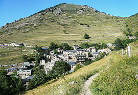
 A general view of Mantet | |
| Coordinates: 42°28′41″N 2°18′28″E / 42.4781°N 2.3078°E | |
| Country | France |
| Region | Occitania |
| Department | Pyrénées-Orientales |
| Arrondissement | Prades |
| Canton | Le Canigou |
| Government | |
| • Mayor (2020–2026) | Jean-Luc Blaise[1] |
Area 1 | 32.15 km2 (12.41 sq mi) |
| Population (2022)[2] | 35 |
| • Density | 1.1/km2 (2.8/sq mi) |
| Time zone | UTC+01:00 (CET) |
| • Summer (DST) | UTC+02:00 (CEST) |
| INSEE/Postal code | 66102 /66360 |
| Elevation | 1,381–2,688 m (4,531–8,819 ft) (avg. 1,558 m or 5,112 ft) |
| 1 French Land Register data, which excludes lakes, ponds, glaciers > 1 km2 (0.386 sq mi or 247 acres) and river estuaries. | |
Mantet (Catalan: Mentet) is a commune in the Pyrénées-Orientales department in southern France.
Geography
[edit]Mantet is located in the canton of Le Canigou and in the arrondissement of Prades.
The village of Mantet lies at an altitude of 1550 metres about 200 metres below the Col de Mantet. The GR 10 Pyrenean footpath passes through the village so it is one of the few points in the Pyrenees Orientales where hikers can buy provisions and spend the night in comfort.

Population
[edit]Graphs are unavailable due to technical issues. Updates on reimplementing the Graph extension, which will be known as the Chart extension, can be found on Phabricator and on MediaWiki.org. |
| Year | Pop. | ±% p.a. |
|---|---|---|
| 1968 | 4 | — |
| 1975 | 7 | +8.32% |
| 1982 | 23 | +18.52% |
| 1990 | 26 | +1.54% |
| 1999 | 17 | −4.61% |
| 2007 | 22 | +3.28% |
| 2012 | 31 | +7.10% |
| 2017 | 30 | −0.65% |
| Source: INSEE[3] | ||
See also
[edit]References
[edit]- ^ "Répertoire national des élus: les maires". data.gouv.fr, Plateforme ouverte des données publiques françaises (in French). 2 December 2020.
- ^ "Populations de référence 2022" (in French). The National Institute of Statistics and Economic Studies. 19 December 2024.
- ^ Population en historique depuis 1968, INSEE
Wikimedia Commons has media related to Mantet.


