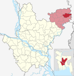
Mithamain Upazila
Mithamoin
মিঠামইন | |
|---|---|
 | |
| Coordinates: 24°25.5′N 91°2.7′E / 24.4250°N 91.0450°E | |
| Country | |
| Division | Dhaka |
| District | Kishoreganj |
| Upazila | 7 November 1983 |
| Headquarters | Mithamain |
| Government | |
| • Upazila Chairman | Asiya Alam |
| • MP (Kishoreganj-4) | Rejwan Ahammad Taufiq |
| Area | |
| • Total | 222.91 km2 (86.07 sq mi) |
| Population | |
| • Total | 125,157 |
| • Density | 560/km2 (1,500/sq mi) |
| Time zone | UTC+6 (BST) |
| Postal code | 2370[2] |
| Area code | 09435[3] |
| Website | mithamoin |
Mithamoin (Bengali: মিঠামইন, romanized: Mithamoin) is an upazila (subdistrict) of Kishoreganj District in northern Bangladesh, located in the Dhaka Division.[4] It is best known as the home upazila of Abdul Hamid, the former President of Bangladesh.
Geography
[edit]Mithamoin is located at 24°25′30″N 91°02′45″E / 24.4250°N 91.0458°E. Mithamoin has 23,850 households and a total land area of 222.91 km2.
History
[edit]The area has been inhabited for centuries. The name of Mithamain can be found in James Rennell's 1781 map of Bengal. The upazila was named after the village of Mithamain. Its etymology is rumored to be that at one time there was a large reed forest in the vicinity of the area. The reed was sweet, and the name of the village came to Mithabon (মিঠাবন sweet forest) which was corrupted to Mithamon and later Mithamain/Mithamoin in the local dialect.
During the Bangladesh Liberation War of 1971, 28 Bengalis were murdered in the village of Dhubajura and 3 in Telikhai on 1 November. Boira was a site of mass killing. On 7 November 1983, Mithamain Thana was upgraded to an upazila.[4]
Demographics
[edit]According to the 2011 Census of Bangladesh, Mithamain Upazila had 23,850 households and a population of 122,026. 39,236 (32.15%) were under 10 years of age. Mithamain had a literacy rate (age 7 and over) of 30.92%, compared to the national average of 51.8%, and a sex ratio of 974 females per 1000 males. 12,600 (10.33%) lived in urban areas.[6][7]
As of the 1991 Bangladesh census, Mithamoin's population is 108,204. The population's male to female ratio is 51.79% to 48.21%. 49,034 of Upazila's population is aged 18 or above. Mithamoin has an average literacy rate of 15.6% (7+ years). The literary rate nationally is 32.4%.[8]
Administration
[edit]Mithamoin Upazila is divided into Mithamoin Municipality and seven union parishads: Bairati, Dhaki, Ghagra, Gopedighi, Khatkhal, Keorjori, and Mithamain. The union parishads are subdivided into 59 mauzas and 135 villages.[6]
Chairmen
[edit]| Name | Term | Notes |
|---|---|---|
| Muhammad Zillur Rahman | 25/5/1985-23/11/1991 | Advocate |
| Qamrul Ahsan Shahjahan | 1/1/2009-6/3/2014 | Advocate |
| Asiya Alam | Present |
Infrastructure
[edit]Land acquisition for a new cantonment was underway by 2016.[9] The Bangladesh Army planned to form a riverine engineer battalion there.[10] Bir Muktijoddha Abdul Hamid Cantonment, built on 275 acres of land along the Ghorauta River, was inaugurated in February 2023.[11]
Notable people
[edit]- Abdul Hamid, longest serving President of Bangladesh
- Rejwan Ahammad Taufiq, politician
See also
[edit]References
[edit]- ^ National Report (PDF). Population and Housing Census 2022. Vol. 1. Dhaka: Bangladesh Bureau of Statistics. November 2023. p. 398. ISBN 978-9844752016.
- ^ "Bangladesh Postal Code". Dhaka: Bangladesh Postal Department under the Department of Posts and Telecommunications of the Ministry of Posts, Telecommunications and Information Technology of the People's Republic of Bangladesh. 20 October 2024.
- ^ "Bangladesh Area Code". Dubai, UAE: My Country Mobile. 18 October 2024.
- ^ a b Shokorana, Mokarram Hussain (2012). "Mithamain Upazila". In Sirajul Islam; Miah, Sajahan; Khanam, Mahfuza; Ahmed, Sabbir (eds.). Banglapedia: the National Encyclopedia of Bangladesh (Online ed.). Dhaka, Bangladesh: Banglapedia Trust, Asiatic Society of Bangladesh. ISBN 984-32-0576-6. OCLC 52727562. OL 30677644M. Retrieved 5 November 2024.
- ^ Population and Housing Census 2022 - District Report: Kishoreganj (PDF). District Series. Dhaka: Bangladesh Bureau of Statistics. June 2024. ISBN 978-984-475-263-4.
- ^ a b "Bangladesh Population and Housing Census 2011 Zila Report – Kishoreganj" (PDF). bbs.gov.bd. Bangladesh Bureau of Statistics.
- ^ "Community Tables: Kishoreganj district" (PDF). bbs.gov.bd. Bangladesh Bureau of Statistics. 2011.
- ^ "Population Census Wing, BBS". Archived from the original on 2005-03-27. Retrieved November 10, 2006.
- ^ "President apprised of planning of proposed Mithamoin Cantonment". The Independent. Dhaka. BSS. 21 March 2016.
- ^ Acharjee, Deepak (16 July 2017). "Army to get 97 more units in 4 years". The Independent. Dhaka.
- ^ "Hasina inaugurates cantonment in Kishoreganj". bdnews24.com. 27 February 2023.

