Faridpur Sadar Upazila
Faridpur Sadar
ফরিদপুর সদর | |
|---|---|
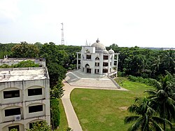
 Muslim Mission Jame Masjid, Faridpur | |
 | |
| Coordinates: 23°35.748′N 89°49.836′E / 23.595800°N 89.830600°E | |
| Country | Bangladesh |
| Division | Dhaka |
| District | Faridpur |
| Government | |
| • Present MP (2009-2018) | Khandaker Mosharraf Hossain |
| • Previous MP | Chowdhury Kamal Ibne Yusuf |
| Area | |
| • Total | 412.86 km2 (159.41 sq mi) |
| Population | |
| • Total | 567,657 |
| • Density | 1,400/km2 (3,600/sq mi) |
| Time zone | UTC+6 (BST) |
| Postal code | 7800[2] |
| Area code | 0631[3] |
| Website | Official Map of Faridpur Sadar |
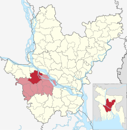
Faridpur Sadar Upazila (Bengali: ফরিদপুর সদর) is an upazila (sub-district) of Faridpur District in the Division of Dhaka, Bangladesh.[4] It contains Faridpur city near the banks of the Padma River.
One of 18 registered red-light districts in Bangladesh is located in Faridpur. About 800 women and girls live and work there.[5]
Geography
[edit]Faridpur Sadar is located at 23°35′45″N 89°49′50″E / 23.5958°N 89.8306°E. It has 103,535 households and total area 412.86 km2.
Demographics
[edit]As of the 2011 Census of Bangladesh, Faridpur Sadar upazila had 103,535 households and a population of 469,410. 98,376 (20.96%) were under 10 years of age. Faridpur Sadar had an average literacy rate of 55.85%, compared to the national average of 51.8%, and a sex ratio of 991 females per 1000 males. 122,425 (26.08%) of the population lived in urban areas.[7][8]
At the 1991 Bangladesh census, Faridpur Sadar had a population of 335,386, of whom 176,469 were aged 18 or older. Males constituted 51.91% of the population, and females 48.09%. Faridpur Sadar had an average literacy rate of 34.2% (7+ years), against the national average of 32.4%.[9]
Administration
[edit]Faridpur Sadar Upazila is divided into Faridpur Municipality and 11 union parishads: Aliabad, Ambikapur, Char Madhabdia, Decreer Char, Greda, Ishan Gopalpur, Kaijuri, Kanaipur, Krishnanagar, Maj Char, and Uttar Channel. The union parishads are subdivided into 157 mauzas and 342 villages.[10]
Faridpur Municipality is subdivided into 9 wards and 41 mahallas.[10]
Elected chairmen of Faridpur Upazila Council
[edit]- Imran Hossain Chowdhury (Jatiya Party) [1984–1989]
- Advocate Alhajj Md. Shamsul Haque (Bhola Master) (Awami League)
- Khondker Mohtesham Hossain Babor (Awami League) [Acting Upazila chairman, Faridpur Sadar Upazila]
Notable residents
[edit]- Abdus Salam Khan, Minister of Public Works and Communication (1955–1956) in the East Pakistan provincial cabinet, was born in Faridpur.[11]
See also
[edit]References
[edit]- ^ National Report (PDF). Population and Housing Census 2022. Vol. 1. Dhaka: Bangladesh Bureau of Statistics. November 2023. p. 398. ISBN 978-9844752016.
- ^ "Bangladesh Postal Code". Dhaka: Bangladesh Postal Department under the Department of Posts and Telecommunications of the Ministry of Posts, Telecommunications and Information Technology of the People's Republic of Bangladesh. 21 October 2024.
- ^ "Bangladesh Area Code". China: Chahaoba.com. 18 October 2024.
- ^ Firoj, Moazzem Hussain (2012). "Faridpur Sadar Upazila". In Islam, Sirajul; Jamal, Ahmed A. (eds.). Banglapedia: National Encyclopedia of Bangladesh (Second ed.). Asiatic Society of Bangladesh.
- ^ Hagler-Geard, Tiffany (3 January 2012). "I am "Chowkri"- Inside Bangladesh's Biggest Brothel". ABC News. Retrieved 30 January 2019.
- ^ Population and Housing Census 2022 - District Report: Faridpur (PDF). District Series. Dhaka: Bangladesh Bureau of Statistics. June 2024. ISBN 978-984-475-265-8.
- ^ "Bangladesh Population and Housing Census 2011 Zila Report – Faridpur" (PDF). bbs.gov.bd. Bangladesh Bureau of Statistics.
- ^ "Community Tables: Faridpur district" (PDF). bbs.gov.bd. Bangladesh Bureau of Statistics. 2011.
- ^ "Population Census Wing, BBS". Archived from the original on 27 March 2005. Retrieved 10 November 2006.
- ^ a b "District Statistics 2011: Faridpur" (PDF). Bangladesh Bureau of Statistics. Archived from the original (PDF) on 13 November 2014. Retrieved 14 July 2014.
- ^ Karim, ASM Enayet (2012). "Khan, Abdus Salam". In Islam, Sirajul; Jamal, Ahmed A. (eds.). Banglapedia: National Encyclopedia of Bangladesh (Second ed.). Asiatic Society of Bangladesh.

