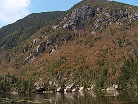
Wildcat Mountain (New Hampshire)
| Wildcat Mountain A | |
|---|---|
 Wildcat A rises over Carter Notch | |
| Highest point | |
| Elevation | 4,422 ft (1,348 m) |
| Prominence | 1,034 ft (315 m) |
| Listing | White Mountain 4,000-footers |
| Coordinates | 44°15′32″N 71°12′05″W / 44.25889°N 71.20139°W |
| Geography | |
 | |
| Location | Coös County, New Hampshire, U.S. |
| Parent range | Carter-Moriah Range |
| Topo map | USGS Carter Dome |
| Wildcat Mountain D | |
|---|---|
 | |
| Highest point | |
| Elevation | 4,062 ft (1,238 m) |
| Prominence | 287 ft (87 m) |
| Listing | White Mountain 4,000-footers |
| Climbing | |
| Easiest route | Via Wildcat Mountain Ski Area gondola lift |
Wildcat Mountain is a mountain located in Coos County, northern New Hampshire, United States. The mountain is part of the Carter-Moriah Range of the White Mountains, on the east side of Pinkham Notch. Wildcat Mountain faces Carter Dome across Carter Notch to the northeast, and Mount Washington across Pinkham Notch to the west.
Wildcat Mountain has five summits — A, B, C, D, and E — along Wildcat Ridge, which curves two miles (3.2 km) to the south and west. Both A, at 4,422 feet (1,348 m), and D, at 4,062 feet (1,238 m), are considered "four-thousand footers". B, with an elevation of 4,305 feet (1,312 m), and C, at 4,285 feet (1,306 m), lack the topographic prominence to be considered more than subpeaks of Wildcat A. Likewise, the E peak, at 4,046 feet (1,233 m), is considered to be a subpeak of the higher D peak (the E peak was formerly believed to be the higher of the two, and used to appear on the official list of four-thousand footers, but current topographic maps reveal the D peak to be the higher summit).
The Appalachian Trail, which extends over 2,170 miles (3,490 km) from Georgia to Maine, climbs up from the Appalachian Mountain Club's Joe Dodge Lodge in Pinkham Notch and traverses the summits of the Wildcat Ridge, continuing on to Carter Dome.
The Wildcat Mountain Ski Area is one of the best-known alpine skiing resorts in New England, with lifts from the base on NH Route 16 in Pinkham Notch 2,112 ft (644 m) up to the D summit. The area has 49 trails on 225 acres (0.91 km2), including Polecat Trail—the longest ski trail in New Hampshire. The Wildcat Valley Trail, an ungroomed cross-country ski trail, leads from the summit down to Jackson, New Hampshire, dropping 3,240 ft (990 m) in 11.1 miles (17.9 km). Cut in 1972, it is one of the best-known routes in the extensive trail system maintained by the Jackson Ski Touring Foundation.
Climate
[edit]| Climate data for Wildcat Mountain 44.2558 N, 71.1981 W, Elevation: 4,016 ft (1,224 m) (1991–2020 normals) | |||||||||||||
|---|---|---|---|---|---|---|---|---|---|---|---|---|---|
| Month | Jan | Feb | Mar | Apr | May | Jun | Jul | Aug | Sep | Oct | Nov | Dec | Year |
| Mean daily maximum °F (°C) | 19.3 (−7.1) |
21.2 (−6.0) |
27.9 (−2.3) |
39.6 (4.2) |
52.7 (11.5) |
60.9 (16.1) |
65.6 (18.7) |
64.3 (17.9) |
58.5 (14.7) |
46.2 (7.9) |
34.3 (1.3) |
24.8 (−4.0) |
42.9 (6.1) |
| Daily mean °F (°C) | 11.4 (−11.4) |
12.8 (−10.7) |
19.3 (−7.1) |
31.2 (−0.4) |
44.1 (6.7) |
53.0 (11.7) |
57.9 (14.4) |
56.7 (13.7) |
50.5 (10.3) |
38.7 (3.7) |
27.5 (−2.5) |
17.7 (−7.9) |
35.1 (1.7) |
| Mean daily minimum °F (°C) | 3.5 (−15.8) |
4.4 (−15.3) |
10.7 (−11.8) |
22.7 (−5.2) |
35.6 (2.0) |
45.1 (7.3) |
50.3 (10.2) |
49.0 (9.4) |
42.5 (5.8) |
31.3 (−0.4) |
20.8 (−6.2) |
10.6 (−11.9) |
27.2 (−2.7) |
| Average precipitation inches (mm) | 5.36 (136) |
4.63 (118) |
5.53 (140) |
6.65 (169) |
6.19 (157) |
6.94 (176) |
6.78 (172) |
5.81 (148) |
5.84 (148) |
9.12 (232) |
6.91 (176) |
6.54 (166) |
76.3 (1,938) |
| Source: PRISM Climate Group[1] | |||||||||||||
See also
[edit]References
[edit]- ^ "PRISM Climate Group, Oregon State University". PRISM Climate Group, Oregon State University. Retrieved October 26, 2023.
To find the table data on the PRISM website, start by clicking Coordinates (under Location); copy Latitude and Longitude figures from top of table; click Zoom to location; click Precipitation, Minimum temp, Mean temp, Maximum temp; click 30-year normals, 1991-2020; click 800m; click Retrieve Time Series button.
External links
[edit]- U.S. Geological Survey Geographic Names Information System: Wildcat Mountain
- Peakbagger.com: Wildcat Mountain
- Peakbagger.com: Wildcat “D”
- Summitpost.org: Wildcat Mountain
- AMC: Hiking Wildcat Mountain
- hikethewhites.com: Wildcat Mountain
- Wildcat Mountain Ski Area
- TrailBlazersNE Wildcat Mountain Trail Profile
- Jackson Ski Touring Foundation: Wildcat Valley Trail
- Wildcat Mountain - New England's Alpine CCC Ski Trails
