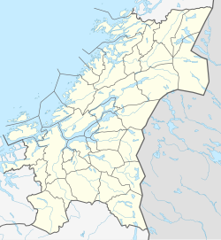
Voll, Trøndelag
Appearance
Voll
Rennebu | |
|---|---|
Village | |
 | |
| Coordinates: 62°52′38″N 9°50′23″E / 62.8771°N 09.8396°E | |
| Country | Norway |
| Region | Central Norway |
| County | Trøndelag |
| District | Orkdalen |
| Municipality | Rennebu Municipality |
| Elevation | 223 m (732 ft) |
| Time zone | UTC+01:00 (CET) |
| • Summer (DST) | UTC+02:00 (CEST) |
| Post Code | 7393 Rennebu |
Voll (historically: Rennebu)[2] is a village in Rennebu Municipality in Trøndelag county, Norway. The village is located in the Orkladalen valley, along the Orkla River, about 5 kilometres (3.1 mi) north of the village of Stamnan and about 16 kilometres (9.9 mi) northeast of the mountain village of Nerskogen. Rennebu Church is located in the village.[3]
References
[edit]- ^ "Voll, Rennebu (Trøndelag)". yr.no. Retrieved 2018-01-25.
- ^ "Informasjon om stadnamn". Norgeskart (in Norwegian). Kartverket. Retrieved 2025-01-11.
- ^ Askheim, Svein; Haugen, Morten O., eds. (2024-11-26). "Voll – Rennebu". Store norske leksikon (in Norwegian). Foreningen Store norske leksikon. Retrieved 2025-01-11.


