Vleteren
Appearance
Vleteren | |
|---|---|
 | |
| Coordinates: 50°56′N 02°44′E / 50.933°N 2.733°E | |
| Country | |
| Community | Flemish Community |
| Region | Flemish Region |
| Province | West Flanders |
| Arrondissement | Ypres |
| Government | |
| • Mayor | Stephan Mourisse (Open Vld) |
| • Governing party/ies | Landelijke Volkspartij (LVP) |
| Area | |
• Total | 38.58 km2 (14.90 sq mi) |
| Population (2018-01-01)[1] | |
• Total | 3,659 |
| • Density | 95/km2 (250/sq mi) |
| Postal codes | 8640 |
| NIS code | 33041 |
| Area codes | 057 |
| Website | www.vleteren.be |
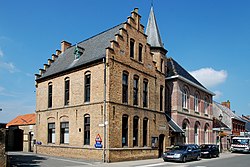
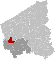
Vleteren (Dutch pronunciation: [ˈvleːtərə(n)]) is a municipality located in the Belgian province of West Flanders. The municipality comprises the towns of Oostvleteren, Westvleteren and Woesten. On January 1, 2006, Vleteren had a total population of 3,636. The total area is 38.15 km2 which gives a population density of 95 inhabitants per km2.


References
[edit]- ^ "Wettelijke Bevolking per gemeente op 1 januari 2018". Statbel. Retrieved 9 March 2019.
External links
[edit] Media related to Vleteren at Wikimedia Commons
Lua error in Module:Navbox at line 535: attempt to get length of local 'arg' (a number value). Lua error in Module:Navbox at line 535: attempt to get length of local 'arg' (a number value).


