User:Vonderk4/sandbox

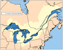
The Great Lakes Basin is defined by watersheds that drain into the Great Lakes of North America. The basin encompasses the surrounding U.S. states of Illinois, Indiana, Michigan, Minnesota, New York, Ohio, Pennsylvania, and Wisconsin, and the Canadian province of Ontario. The direct surface runoff and watersheds from these lands form a large drainage basin that feeds into the lakes, which make up 85% of North America’s and 20% of the world’s surface freshwater resources. The basin covers about 94,000 square miles (240,000 square km). About 8% of the U.S. population and 32% of the Canadian population live within the Basin, which lies at the center of the Great Lakes region. [1]
According to the Great Lakes Water Quality Agreement of 2012, the Great Lakes Basin Ecosystem is defined as “the interacting components of air, land, water and living organisms, including humans, and all of the streams, rivers, lakes, and other bodies of water, including groundwater, that are in the drainage basin of the Great Lakes and the St. Lawrence River at the international boundary or upstream from the point at which this river becomes the international boundary between Canada and the United States.” [2]
Formation
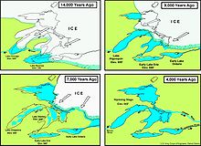
[edit]The formation of the Great Lakes Basin began around 10,000 years ago when the glaciers from the most recent Ice Age began to retreat northward. While the lakes formed by glacial erosion, the geological features that formed 300 to 1200 million years ago most likely predetermined the shapes of the Great Lakes. The last wave of the Pleistocene glaciation was at its maximum extent between approximately 25,000 and 21,000 years ago. Ahead of the glacial lobes were terminal moraines that would eventually help dam the lakes. The ice sheets were most likely around 3,000 feet (1,000 meters) thick in the Great Lakes region. As the glaciers retreated they followed the easiest path, typically tracing alongside preexisting drainages that had formed in weaker rocks exposed at the surface. [3]

The basin that was left in the area surrounding the lakes was the result of the slow rise of land rebounding from the weight of thick ice sheets. Lake Erie and southern Lake Michigan (called Lake Chicago then) were the first lakes created. Lake Erie drained to the southwest out of the Maumee-Wabash-Ohio rivers, while Lake Chicago drained in the same direction to the Plaines-Illinois rivers. About 9,000 years ago, the southwest part of Lake Superior (Lake Duluth) began to form, which drained southwest to the St. Croix and Mississippi rivers. Around 7,000 years ago Lake Ontario began to form. The land to the southwest of Lake Erie began to rise, making the Niagara River the new outlet for Lake Erie. As the ice sheets continued to retreat, Lakes Superior, Michigan, and Huron were all one lake called Lake Nipissing. This huge lake had three outlets (the Ottawa-St. Lawrence rivers, Detroit-St. Clair rivers, and Illinois-Mississippi rivers). Over time the lakes separated as land began to rise again. It was only about 3,000 years ago that the Great Lakes assumed their present shapes as well as the boundaries of the basin. [4]
Geology
[edit]
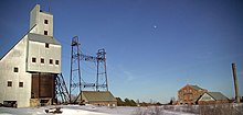
The bedrock geology of the Great Lakes Basin is Precambrian in the northern part of the basin and Phanerozoic in the southern part. The oldest bedrock in the Great Lakes Basin comes from the Precambrian era. This bedrock is approximately 3.6 billion years old and is located in the western Upper Peninsula of Michigan. A few large geologic events buried minerals such as iron and copper in the region, which led to a spike in mining in the late 19th and early 20th centuries. By the end of the Precambrian, the Great Lakes Basin was a barren bedrock surface devoid of life besides algae and bacteria. Around 542 million years, the Phanerozoic era began and was characterized by intervals of shallow seas and dry land. During this time, sandstone, shale, limestone, dolostone, and salt were deposited in the basin. Before glaciation occurred, Phanerozoic bedrock was present throughout the entire basin. Glacial action in the northern parts of the basin caused the Precambrian bedrock to become exposed to what is seen today. The movement of glaciers also left behind large amounts of sand and gravel throughout the basin.[5]
Demographics & Parks
[edit]The basin is home to 37 million people in the United States and Canada.[6] This is around 8% of the U.S. population and 32% of Canada’s population.[7] The basin hosts eight of Canada's 20 largest cities, including Toronto, Hamilton, London, St. Catharines, Niagara, Oshawa, Windsor, and Barrie. On the United States side are many large cities on the shores of the Great Lakes, including Duluth, Milwaukee, Chicago, Gary, Detroit, Toledo, Cleveland, Erie, Buffalo, Rochester, and Syracuse.

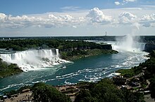
The Great Lakes Basin is also home to various parks, protected areas, and landmarks. In the United States, two national parks are located within the basin: Isle Royale National Park and Indiana Dunes National Park. There are also three National Lakeshores: Pictured Rocks National Lakeshore, Apostle Islands National Lakeshore, and Sleeping Bear Dunes National Lakeshore. In Canada, there are five national parks: Pukaskwa National Park, Bruce Peninsula National Park, Point Pelee National Park, Georgian Bay Islands National Park, and Thousand Islands National Park. Other popular landmarks include Niagara Falls and Mackinac Island.
Sub-basins
[edit]Each individual lake forms a sub-basin, including the Lake Erie Basin, Lake Huron Basin, Lake Michigan Basin, Lake Ontario Basin, and Lake Superior Basin. Each sub-basin consists of multiple watersheds. The overall Great Lakes Basin is monitored by the binational Great Lakes Commission.
St. Lawrence Basin
[edit]
The St. Lawrence River watershed is often grouped with the Great Lakes Basin because of its important connection between the Great Lakes and the Atlantic Ocean and because of the St. Lawrence River Divide (a continental divide in central and eastern North America). [8] The watershed is one of the world’s most diverse with 3,500 species of plants and wildlife and more than 250 species of fish.[9] Quebec, a portion of whose lands drain into the St. Lawrence Basin, is a signatory to the Great Lakes Charter of 1985, the 2001 Charter Annex, and the Agreements of 2005.[10] While not a part of the Great Lakes Basin, Quebec's position along the Saint Lawrence Seaway makes it a partner in water resource management with Ontario and the eight US states mentioned above.
See also
[edit]|
|
Notes
[edit]- ^ "AN OVERVIEW OF THE GEOLOGY OF THE GREAT LAKES BASIN" (PDF).
{{cite web}}: CS1 maint: url-status (link) - ^ "Nuclear Power Facilities in the Great Lakes Basin" (PDF).
{{cite web}}: CS1 maint: url-status (link) - ^ "Making the Great Lakes | EarthDate". www.earthdate.org. Retrieved 2020-10-23.
- ^ "How They Were Made". Retrieved 2020-09-30.
- ^ Bornhorst, Theodore (2016). "An Overview of the Geology of the Great Lakes Basin" (PDF). A. E. Seaman Mineral Museum.
- ^ "Archived copy". Archived from the original on 2015-11-01. Retrieved 2015-10-29.
{{cite web}}: CS1 maint: archived copy as title (link) - ^ "Great Lakes fast facts | Michigan Sea Grant". Retrieved 2020-10-23.
- ^ "About | Great Regional Body". www.glslcompactcouncil.org. Retrieved 2020-10-23.
- ^ "Great Lakes - St. Lawrence River | International Joint Commission". ijc.org. Retrieved 2020-10-23.
- ^ Great Lakes Basin Sustainable Water Resources Agreement, Government of Quebec
External links
[edit] | This is a user sandbox of Vonderk4. You can use it for testing or practicing edits. This is not the sandbox where you should draft your assigned article for a dashboard.wikiedu.org course. To find the right sandbox for your assignment, visit your Dashboard course page and follow the Sandbox Draft link for your assigned article in the My Articles section. |
