
User:Olahus

| This is a Wikipedia user page. This is not an encyclopedia article or the talk page for an encyclopedia article. If you find this page on any site other than Wikipedia, you are viewing a mirror site. Be aware that the page may be outdated and that the user whom this page is about may have no personal affiliation with any site other than Wikipedia. The original page is located at http://en.wikipedia.org/wiki/User:Olahus. |

Beliefs
|

| |||
Hi! I am the user Olahus. I am interested in the history and geography of Central, Eastern and Southeastern Europe.
I am a registered user since May 2006.

African Americans, also known as Afro-Americans or Black Americans, are an ethnic group in the United States consisting of Americans with partial or total ancestry from any of the Black racial groups of Africa. African Americans constitute the third largest racial or ethnic group in the United States, after White Americans and Hispanic and Latino Americans. Most African Americans are descendants of enslaved people in the United States, having West African and coastal Central African ancestry, with varying amounts of Western European and Native American ancestry. This ambrotype photograph, taken circa 1863 to 1865, depicts Sergeant Samuel Smith, an African-American soldier of the Union Army's 119th United States Colored Troops, with his wife and two daughters.Photograph credit: unknown
Images uploaded by me
[edit]Maps created by me
[edit]
.PNG)
.PNG)
.PNG)
.PNG)
.PNG)


.png)

.PNG)
.PNG)
.PNG)


.PNG)


Scanned images
[edit]-
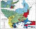
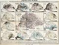
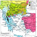 Ethnic map of the Balkan Peninsula (1898)
 -
 The Austrian Empire during the XVII century
 -
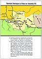
 The Carolingian Empire after the Treaty of Verdun
 -
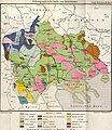
 Ethnic map of European Russia before the First World War
 -
 Ethnographic map of Dobruja (1918)
 -
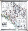 The Principality of Montenegro in 1862
 -
 Major Lithuanian linguistic areal in 1876.
 -
 Ethnic Germans in Hungary and parts of adjacent Austrian territories, census 1890
 -
 Demographic map of Italy and surroundung regions (1859)
 -
 Linguistic map of Slovenia and surrounding regions (census 1880)
 -
 Linguistic map of Istria (census 1880)
 -
 The Romanian Old Kingdom (1901)
 -
 Bulgaria in 1901
 -
 General map of Rumania (1967)
 -
 Confessions in Central Europe
 -
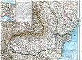
 Bukovina in 1901
 -
 Political map of Europe (1899)
 -
 Political map of Asia (1899)
 -
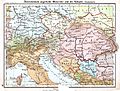 Main subdivisions of Austria-Hungary (1899).
 -
 Political map of South America (1899)
 -
 Extermination of the American Bison to 1889
 -
 The density of the railway net in Europe (1902)
 -
 Map of Greece and European Turkey (1829)
 -

-
 The United States in 1829
 -
 Europe in 1828
 -
 Austria-Hungary in 1828
 -
 The German confederation (1828)
 -
 The Ottoman Empire in Asia (1829)
 -
 The American continent in 1828
 -
 Africa in 1828
 -
 Asia in 1829
 -
 The Russian Empire in 1828
 -
 The world map (1829)
 -
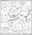
 Historical map of Switzerland
 -
 The Lake Lucerne (1829)
 -
-

-

-
-

-

-

-

-

-

-

-

-

-

-

-

-

-

-

-

-
-

-

-

-

-

-

-
-

-

-
-

-

-

-

-

-

-

-

-

-

-

-

-

-

-

-

-

-

-

-

-

-

-

-

-

-
 Ethnographic map of the Epirus region, 1878. Greek point of view
 -
 Walser settlements in northwestern Italy


.JPG)

.JPG)


.jpg)
.JPG)


.JPG)


.JPG)
.jpg)
.JPG)


.JPG)


_1892.JPG)

.JPG)
.jpg)

.JPG)


.jpg)

.JPG)

.jpg)


.JPG)
.jpg)

.jpg)
.jpg)


.jpg)


.JPG)


