User:Nopperman1
Neil's WikiProject Homepage
[edit]Summary of Featured Articles and Good Articles
[edit]In order to become a featured article, you must obtain the little bronze star that would be placed in the upper right corner of the article page. When that bronze star is observed on the top right corner, then you know that it is a featured article. A featured article is one that shows the best that Wikipedia has to offer in that it is the end result (or polished as they call it) of a collaborative effort to create an article that gives the best information that is possible by the users that helped to contribute. It showcases what Wikipedia is all about and can be seen as an example for the rest of the articles.
As far as I can tell, on the WikiProject-Meteorlogy homepage, there is a scale in which the articles are being rated. With FA being the highest, A, then GA, B, Start, Stub, Current, and needed. By looking at the number of articles in each quality category, it looks like this project is really struggling with A and FA rated articles with most lying in the start and stub regions of quality.
WikiProject: Proposal
[edit]Currently I am considering doing my wiki project on the mesoscale phenomena of microburst winds. I have been fascinated with the way in which microburst winds have caused severe damage in a relatively small area. I am also intrigued by the outflow which has pure divergence characteristics that is also seen with some microbursts. Upon digging around Wikipedia, I found that there is an article that is written on microbursts, but it is not a large article and could have more information posted to it. Another alternative is to focus primarily on dry microbursts, an event which can be seen here in Utah and is one of the reasons I have interest in this subject. The internet has many sources of information relating to the subject and can be a valuable source of information. Seen below are just a couple of links in which I felt were reliable sources of information that I can pull from in order to contribute to the Microburst article found on Wikipedia. My contribution would focus on the why part of microbursts and not so much the what part. I would try to explain using the knowledge gained from my meteorology classes and especially my mesoscale/radar meteorology class to help explain what is happening and why it is happening when a microburst occurs. Microbursts can be extremely dangerous and have proven deadly in the past and I feel it is important that as much information as possible can be obtained on these powerful wind events.

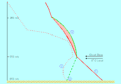
(1) A steep, nearly dry adiabatic lapse rate is present due to afternoon surface heating; (2) low relative humidity below cloud base develops in response to deep convective boundary layer mixing; (3) local moisture variations can increase the surface dewpoint/humidity; and (4) CAPE (red-shaded area) values are generally low (<500 J kg-1) due to the lack of significant low-level moisture.
Microburst
Microburst Handbook
University of Illinois
NCAR
NOAA
The Weather Doctor
Charles A. Doswell III Paper
WikiProject: Microbursts
[edit]
Definition
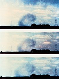
A microburst is an intense windshear. A small, very intense downdraft that descends to the ground resulting in a strong wind divergence (outflow of winds equal in all directions upon impact). The size of the event is typically less than 4 kilometers (2.5 miles) across. Microbursts are capable of producing tornado-strength winds with gusts as high as 75 m/s (168 MPH) causing significant damage. The life span of a microburst wind event is around 5-15 minutes.

Dry Microburst
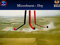
When rain falls below cloud base or is mixed with dry air, it begins to evaporate and this evaporation process cools the air. The cool air descends and accelerates as it approaches the ground. When the cool air approaches the ground, it spreads out in all directions and this divergence of the wind is the signature of the microburst.
Dry microbursts, produced by high based thunderstorms that generate little surface rainfall, occur in environments characterized by a thermodynamic profile exhibiting an inverted-V at thermal and moisture profile, as viewed on a Skew-T log-P thermodynamic diagram. (Wakimoto, 1985) developed a conceptual model (over the High Plains) of a dry microburst environment that comprised of three important variables: mid-level moisture, a deep and dry adiabatic lapse rate in the sub-cloud layer, and low surface relative humidity.

Wet Microburst
Wet microbursts are downbursts accompanied by significant precipitation at the surface (Fujita, 1985) which are warmer than their environment (Wakimoto, 1998). These downbursts rely more on the drag of precipitation for downward acceleration of parcels than negative buoyancy which tend to drive "dry" microbursts. As a result, higher mixing ratios are necessary for these downbursts to form (hence the name "wet" microbursts). Melting of ice, particularly hail, appears to play an important role in downburst formation (Wakimoto and Bringi, 1988), especially in the lowest one kilometer above ground level (Proctor, 1989). These factors, among others, make forecasting wet microbursts a difficult task.
| Characteristic | Dry Microburst | Wet Microburst |
|---|---|---|
| Location of Highest Probability | Midwest/West | Southeast |
| Precipitation | Little or none | Moderate or heavy |
| Cloud Bases | As high as 500 mb | Usually below 850 mb |
| Features below Cloud Base | Virga | Shafts of strong precipitation reaching the ground |
| Primary Catalyst | Evaporative cooling | Downward transport of higher momentum |
| Environment below Cloud Base | Deep dry layer/low relative humidity/dry adiabiatic lapse rate | Shallow dry layer/high relative humidity/moist adiabatic lapse rate |
| Surface Outflow Pattern | Omni-directional | Gusts of the direction of the mid-level wind |
Process of Wet and Dry Microbursts
Simple, Easy Explanation
In the case of a wet microburst, the atmosphere is warm and humid in the lower levels and dry aloft. As a result, when thunderstorms develop, heavy rain is produced but some of the rain evaporates in the drier air aloft. As a result the air aloft is cooled thereby causing it to sink and spread out rapidly as it hits the ground. The result can be both strong damaging winds and heavy rainfall occurring in the same area. Wet downbursts can be identified visually by such features as a shelf cloud, while on radar they sometimes produce bow echoes.
In the case of a dry microburst, the atmosphere is warm but dry in the lower levels and moist aloft. Thus when showers and thunderstorms develop, most of the rain evaporates before reaching the ground.
Basic Physical Processes using Simplified Buoyancy Equations
Start by using the vertical momentum equation
.
By decomposing the variables into a basic state and a perturbation, defining the basic states, and using the Ideal Gas Law (p = ρRTv), then the equation can be written in the form
where B is used to denote buoyancy. Note that the virtual temperature correction usually is rather small and to a good approximation, it can be ignored when computing buoyancy. Finally, the effects of precipitation loading on the vertical motion are parameterized by including a term that decreases buoyancy as the liquid water mixing ratio (l) increases, leading to the final form of the parcel's momentum equation:
The first term is the effect of perturbation pressure gradients on vertical motion. In some storms this term has a large effect on updrafts (Rotunno and Klemp, 1982) but there is not much reason to believe it has much of an impact on downdrafts (at least to a first approximation) and therefore will be ignored.
The second term is the effect of buoyancy on vertical motion. Cleary, in the case of microbursts, one expects to find that B is negative meaning the parcel is cooler than its environment. This cooling typically takes place as a result of phase changes (evaporation, melting, and sublimation). Precipitation particles that are small, but are in great quantity, promote a maximum contribution to cooling and, hence, to creation of negative buoyancy. The major contribution to this process is from evaporation.
The last term is the effect of water loading. Whereas evaporation is promoted by large numbers of small droplets, it only takes a few large drops to contribute substantially to the downward acceleration of air parcels. This term is associated with storms having high precipitation rates. Comparing the effects of water loading to those associated with buoyance, if a parcel has a liguid water mixing ration of 1.0 gkg-1, this is roughly equivilant to about 0.3 deg K of negative buoyancy; the latter is a large (but not extreme) value. Therefore, in general terms, negative buoyancy is typically the major contributor to downdrafts.
Negative Vertical Motion Associated only with Buoyancy
Using pure "parcel theory" results in a prediction of the maximum downdraft of
where NAPE is the Negative Available Potential Energy,
and where LFS denotes the Level of Free Sink for a descending parcel and SFC denotes the surface. This means that the maximum downward motion is associated with the integrated negative buoyancy. Even a relatively modest negative buoyancy can result in a substantial downdraft if it is maintained over a relatively large depth. A downward speed of 25 m/s results from the relatively modest NAPE value of 312.5 m2s-2. To a first approximation, the maximum gust is roughly equal to the maximum downdraft speed.
See the following reference and link for more information on derivation of buoyancy equations:
Extreme Convective Windstorms: Current Understanding and Research
Microbursts: Wind Shear Problems for Airplanes


An editor has nominated the above file for discussion of its purpose and/or potential deletion. You are welcome to participate in the discussion and help reach a consensus.
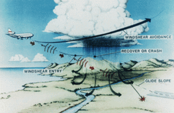
Wind shear is a rapid change of wind speed or direction over a short distance. In general, windshear becomes a hazard for aircraft if the wind changes more than 20 knots over a distance of 1-4 km (0.5 to 2.5 nm). On either takeoff or landing, aircraft are near stall speeds. When going through a windshear, the headwind decreases resulting in a loss of lift. If the aircraft is near stall, then a little loss of lift can make all the difference to whether the aircraft can continue the flight.
As a downdraft spreads down and outward from a cloud, it creates an increasing headwind over the wings of an oncoming aircraft. This headwind causes a sudden leap in airspeed, and the plane lifts. If the pilots are unaware that this speed increase is caused by windshear, they are likely to react by reducing engine power. However, as the plane passes through the shear, the wind quickly becomes a downdraft and then a tailwind. This reduces the speed of air over the wings, and the extra lift and speed vanish. Because the plane is now flying on reduced power, it is vulnerable to sudden loss of airspeed and altitude. The pilots may be able to escape the microburst by adding power to the engines. But if the shear is strong enough, they may be forced to crash.
Greatest danger: Takeoff and landing
Windshear poses the greatest danger to aircraft during takeoff and landing, when the plane is close to the ground and has little time or room to maneuver. During landing, the pilot has already reduced engine power and may not have time to increase speed enough to escape the downdraft. During takeoff, an aircraft is near stall speed and thus is very vulnerable to windshear.
 University of Utah -- Department of Meteorology
| This user is a member of WikiProject Meteorology. |
