User:Masterhatch/sandbox
Building sandcastles in my sandbox!
My projects
[edit]Quick links
[edit]- List of protected areas of Saskatchewan
- Canadian Register of Historic Places
- List of historic places in Saskatchewan
- List of historic places in rural municipalities of Saskatchewan
- List of National Historic Sites of Canada in Saskatchewan
- List of Saskatchewan provincial highways
- Saskatchewan Water Security Agency
- List of dams and reservoirs in Canada
- List of airports in Saskatchewan
- List of defunct airports in Canada
- List of rivers of Canada
- List of lakes of Canada
Communities of Saskatchewan
[edit]- List of communities in Saskatchewan
- List of municipalities in Saskatchewan
- List of rural municipalities in Saskatchewan
- List of designated places in Saskatchewan
- List of Indian reserves in Saskatchewan
- List of cities in Saskatchewan
- List of towns in Saskatchewan
- List of villages in Saskatchewan
- List of hamlets in Saskatchewan
- List of resort villages in Saskatchewan
- List of ghost towns in Saskatchewan
- List of population centres in Saskatchewan
- List of census divisions of Saskatchewan
- List of regions of Saskatchewan
To do and / or clean up
[edit]- Qu'Appelle River
- Nanaimo Lakes and add ski hill
- Mount Washington (British Columbia)
- Porcupine Provincial Forest merge with Porcupine Provincial Forest (Manitoba)?
- Frog Lake National historical site??
- Old Man On His Back Plateau
- Beaver Hills (Saskatchewan)
- merge Roads in Canada and Numbered highways in Canada?
- Look at (clean up, add to) all the islands in Saskatchewan
Future projects
[edit]- Czechs in WHA? [1] 1977–78 WHA season & 1978–79 WHA season
- Duck Mountain
Redirects and disambigs to create
[edit]- Qualicum
Lake info box
[edit]{{Short description|Lake in Saskatchewan, Canada} {{Use Canadian English|date=October 2024} {{Use dmy dates|date=October 2024}
| Etomami Lake | |
|---|---|
| Location | RM of Preeceville No. 334 |
| Coordinates | 52°15′20″N 102°39′04″W / 52.2556°N 102.6512°W |
| Type | Bifurcation lake |
| River sources | Porcupine Hills |
| Primary outflows | |
| Basin countries | Canada |
| Surface area | 19.3 ha (48 acres) |
| Shore length1 | 4 km (2.5 mi) |
| Settlements | None |
| 1 Shore length is not a well-defined measure. | |
Etomami Lake[1][2] is a bifurcation lake in the east-central part of the Canadian province of Saskatchewan. The lake is in a glacier-carved valley in the Porcupine Hills within the Rural Municipality of Preeceville No. 334. It is the headwaters for both the Etomami River and the Lilian River. Henry Kelsey of the Hudson's Bay Company travelled past the lake in 1691 where he portaged from one river system to the other. Etomami is Cree for "where 3 rivers join" which is in reference to where three rivers — Etomami, Red Deer, and Fir — meet.[3]
Description
[edit]Etomami Lake is a small, narrow lake with an area of 48 hectares (120 acres)[4] and a shoreline of 4 kilometres (2.5 mi).[5] The lake sits in a glacial spillway in the Porcupine Hills of east-central Saskatchewan and has two outflows. The Etomami River flows out of the north end of the lake where it meets the Red Deer River near the town of Hudson Bay. The Lilian River flows out from the southern end of the lake and meets the Assiniboine River at Sturgis. Both rivers are within the Nelson River watershed.
In 1691, Hudson's Bay Company fur trader and explorer Henry Kelsey travelled up the Etomami River to Etomami Lake where he crossed the portage to Lilian River.[6]
See also
[edit]References
[edit]- ^ "Etomami Lake". Canadian Geographical Names Database. Government of Canada. Retrieved 2 October 2024.
- ^ https://fishbrain.com/fishing-waters/oXM4lUsu/etomami-lake
- ^ https://townofhudsonbay.com/history/
- ^ https://www.anglersatlas.com/place/111099/etomami-lake
- ^ https://sasklakes.ca/etomami-lake/
- ^ https://www.researchgate.net/figure/Map-showing-the-positions-of-Aboriginal-trails-and-significant-centres-in-the-study_fig6_291344958
{{Canada topic|List of lakes of} {{Authority control}
[[Category:Lakes of Saskatchewan] [[Category:Bifurcation lakes] [[Category:Preeceville No. 334, Saskatchewan]
{{Saskatchewan-geo-stub}
{{Canada-lake-stub}
River info box
[edit]Lilian River, Lilian River (Saskatchewan)
{{Short description|River in Saskatchewan, Canada} {{Use Canadian English|date=October 2024} {{Use dmy dates|date=October 2024}
| Lilian River | |
|---|---|
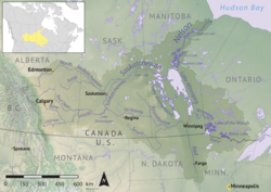
 Map of the Nelson River drainage basin | |
| Location | |
| Country | Canada |
| Province | Saskatchewan |
| Physical characteristics | |
| Source | Lilian Lake |
| • location | RM of Preeceville No. 334 |
| • coordinates | 52°13′33″N 102°39′05″W / 52.2259°N 102.6515°W |
| Mouth | Assiniboine River |
• location | Sturgis |
• coordinates | 51°56′25″N 102°32′58″W / 51.9403°N 102.5494°W |
| Basin features | |
| River system | Nelson River |
| Tributaries | |
| • left | Kop Creek |
Lilian River[1] is a river in the Canadian province of Saskatchewan. The river begins at Lilian Lake[2] in the Porcupine Hills and flows south to join to the Assiniboine River at the town of Sturgis. Lilian Lake is connected to the bifurcating Etomami Lake via a natural swampy portage making Etomami Lake the headwaters for both the north flowing Etomami River and the south flowing Lilian River. For most of the river's length, it is followed by the Canadian National Railway (CNR) and Highway 9. Several small communities and parks are situated on or near the river's banks.
History
[edit]In 1691, Hudson's Bay Company fur trader and explorer Henry Kelsey traversed the natural portage between the Etomami and Lilian Rivers while in search of a route to the aspen parkland region. He had travelled south up the Etomami River from the Red Deer River to Etomami Lake where he crossed over to the Lilian River system. The Lilian River led him to the Assiniboine River. He was following a trail known to be used by the local Indigenous peoples.[3]
Description
[edit]Lilian River begins at the southern end of Lilian Lake and flows south out of the Porcupine Hills. Lilian Lake, at 47 hectares (120 acres), is a small lake with the hamlet of Usherville[4] on its western shore. Heading south, alongside the CN Railway, the river runs by Endeavour, Hinchliffe, the Lady Lake section of Sturgis & Lady Lake Regional Park, and Lady Lake. Highway 9 parallels the river from its source to Lady Lake, at which point the highway crosses the river. The railway crosses the river south of Endeavour.[5] Lilian River continues southward towards Sturgis where it once again gets crossed by the railway and Highway 9 before joining the Assiniboine River[6] in the Sturgis section of the Sturgis & Lady Lake Regional Park.
Fish species
[edit]Fish commonly found in Lilian River include northern pike.[7]
See also
[edit]References
[edit]- ^ "Lilian River". Canadian Geographical Names Database. Government of Canada. Retrieved 4 October 2024.
- ^ "Lilian Lake". Canadian Geographical Names Database. Government of Canada. Retrieved 4 October 2024.
- ^ "Contexts in source publication". ResearchGate. ResearchGate GmbH. Retrieved 4 October 2024.
- ^ https://sasklakes.ca/lilian-lake/
- ^ https://www.geodata.us/canada_names_maps/maps.php?featureid=HAOEA&f=247
- ^ https://www.wsask.ca/hydrographs/assiniboine-river-watershed/
- ^ https://www.brmbmaps.com/explore/canada/saskatchewan/preeceville-no-334/lilian-river/11630
{{Authority control}
[[Category:Rivers of Saskatchewan] [[Category:Tributaries of Hudson Bay] [[Category:Preeceville No. 334, Saskatchewan]
Prairie National Wildlife Area
[edit]- Prairie National Wildlife Areas:
| # | Rural municipality | Area | Coordinates | Notes |
|---|---|---|---|---|
| 1 | RM of Clayton No. 333 | 52°04′27″N 102°08′04″W / 52.0742°N 102.1344°W | Eastern most NWA | |
| 2 | RM of Rosthern No. 403 | 52°36′49″N 106°15′44″W / 52.6135°N 106.2623°W | ||
| 3 | RM of Rosthern No. 403 | 52°33′40″N 106°16′27″W / 52.5611°N 106.2741°W | Eastern shore of Hnatiw Lake | |
| 4 | RM of Duck Lake No. 463 | 65 ha (160 acres) | 52°42′07″N 106°11′31″W / 52.7020°N 106.1919°W | |
| 5 | ||||
| 6 | ||||
| 7 | ||||
| 8 | ||||
| 9 | ||||
| 10 | ||||
| 11 | ||||
| 12 | ||||
| 13 | ||||
| 14 | ||||
| 15 | ||||
| 16 | ||||
| 17 | ||||
| 18 | ||||
| 19 | ||||
| 20 | ||||
| 21 | ||||
| 22 | ||||
| 23 | ||||
| 24 | ||||
| 25 | ||||
| 26 | ||||
| 27 | RM of Golden West No. 95 | 259 ha (640 acres) | 49°58′01″N 103°06′34″W / 49.9669°N 103.1094°W | Saint Clair NWA |
- ^ Government of Canada, Natural Resources Canada. "Place names - Prairie National Wildlife Area". www4.rncan.gc.ca.
- ^ https://www.canada.ca/en/environment-climate-change/services/national-wildlife-areas/locations/prairie.html


