Tornes
Appearance
Tornes | |
|---|---|
Village | |
Location in Møre og Romsdal | |
| Coordinates: 62°50′30″N 7°01′47″E / 62.8417°N 7.0298°E | |
| Country | Norway |
| Region | Western Norway |
| County | Møre og Romsdal |
| District | Romsdal |
| Municipality | Hustadvika Municipality |
| Area | |
• Total | 0.43 km2 (0.17 sq mi) |
| Elevation | 17 m (56 ft) |
| Population (2018)[1] | |
• Total | 557 |
| • Density | 1,295/km2 (3,350/sq mi) |
| Time zone | UTC+01:00 (CET) |
| • Summer (DST) | UTC+02:00 (CEST) |
| Post Code | 6443 Tornes i Romsdal |
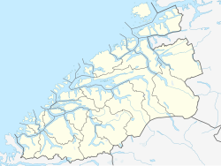
Tornes is a village in Hustadvika Municipality in Møre og Romsdal county, Norway. The village is located along the Julsundet strait at the mouth of the Frænfjorden. It is about 5 kilometres (3.1 mi) west of the municipal center of Elnesvågen and about 12 kilometres (7.5 mi) south of the village of Bud.[3]
The 0.43-square-kilometre (110-acre) village has a population (2018) of 557 and a population density of 1,295 inhabitants per square kilometre (3,350/sq mi).[1]
References
[edit]- ^ a b c Statistisk sentralbyrå (1 January 2018). "Urban settlements. Population and area, by municipality".
- ^ "Tornes, Fræna (Møre og Romsdal)". yr.no. Retrieved 2019-06-02.
- ^ Store norske leksikon. "Tornes" (in Norwegian). Retrieved 2010-11-15.


