Tkuma, Israel
Tkuma
תקומה | |
|---|---|
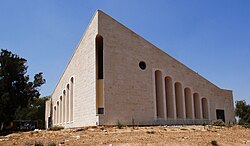
 Village synagogue | |
| Coordinates: 31°26′56″N 34°34′39″E / 31.448751°N 34.577422°E | |
| Country | Israel |
| District | Southern |
| Council | Sdot Negev |
| Affiliation | Hapoel HaMizrachi |
| Founded | 5–6 October 1946 |
| Founded by | Eastern European Jews |
| Population (2022)[1] | 724 |
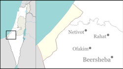
Tkuma (Hebrew: תְּקוּמָה, lit. 'Resurrection') is a religious moshav in southern Israel. Located north-west of Netivot, it falls under the jurisdiction of Sdot Negev Regional Council. In 2022 it had a population of 724.[1]
History
[edit]Tkuma was established as a kibbutz on the night of 5 and 6 October 1946 as one of the 11 points in the Negev at a location around a mile from the present site. The first residents were Jewish immigrants from Eastern Europe, who survived the Holocaust, and the village's name reflects the resurrection of Israel.[citation needed]
In 1949 the village moved to its present location near the site of the depopulated Arab village of al-Muharraqa. Scholar Benny Morris documents that Tkuma is near the al-Muharraqa site, but writer Walid Khalidi says that Tkuma, although only 2 km west of the al-Muharraqa site, is on land which once belonged to the city of Gaza.[2][3]
In the 1950s the moshav was joined by more immigrants from Eastern Europe and Tunisia.[citation needed]
Located five kilometers from the Gaza Strip, the moshav suffered damage from rockets launched by Hamas militants during 2000s and 2010s. The moshav is serviced by the Color Red alert system.[4]

The Car Wall was erected just west of Tkuma, a pile of burnt cars as a memorial for the Re'im music festival massacre on 7 October 2023.
Economy
[edit]Since the 1990s fish farming has been an important economic branch. The sale of fresh fish to banquet halls and restaurants in the northern Negev has provided income for several families.[5]
Archaeology
[edit]In 1964, at Yizre'am, approximately one kilometre southwest of Tkuma, a clay stamp bearing a Greek inscription was discovered, identifying it as belonging to "Silvanus".[6]
References
[edit]- ^ a b "Regional Statistics". Israel Central Bureau of Statistics. Retrieved 21 March 2024.
- ^ Morris, Benny (2004). The Birth of the Palestinian Refugee Problem Revisited. Cambridge: Cambridge University Press. p. xxi. ISBN 978-0-521-00967-6.
- ^ Khalidi, Walid (1992), All That Remains: The Palestinian Villages Occupied and Depopulated by Israel in 1948, Washington D.C.: Institute for Palestine Studies, p. 127, ISBN 0-88728-224-5
- ^ Kershner, Isabel (December 24, 2008). "Gaza Rocket Fire Intensifies". The New York Times. Retrieved April 17, 2019.
- ^ Heruti-Sover, Tali (January 18, 2009). "Gaza War Leads to Creative Marketing and Success". Haaretz. Retrieved April 17, 2019.
- ^ "XXXIII. Yizreʿam", Volume 3 South Coast: 2161-2648, De Gruyter, pp. 531–532, 2014-07-14, doi:10.1515/9783110337679.531, ISBN 978-3-11-033767-9, retrieved 2024-02-25
External links
[edit]- Tkuma Negev Information Centre


