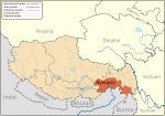
Temo La
29°36′12″N 94°36′21″E / 29.60343°N 94.60575°E

Temo La (Chinese: 德姆拉, 德木拉, Tibetan: དེ་མོ་ལ), a high-altitude mountain pass located in the Tibet Autonomous Region of China, has served as a critical geographical and infrastructural node since the mid-20th century.[1][2]
History
[edit]Historically part of ancient trade routes between Tibet and South Asia, the pass gained strategic importance during the 1950s when China initiated infrastructure projects to strengthen border connectivity. The construction of the Lhasa-Xigaze Highway in 1955 marked the first modern engineering effort to traverse Temo La, enabling year-round access despite its elevation of over 5,000 meters.[3][4]
In the 21st century, Temo La became integral to China's Belt and Road Initiative, with upgrades to the pass's road network (2016–2020) enhancing cargo capacity by 300% and reducing travel time between Tibet and Nepal to under 8 hours (China National Highway 559).[5] These improvements involved advanced engineering solutions, including frost-resistant asphalt and modular bridge systems, to withstand extreme weather. Temo La operates under China's Border Trade Facilitation Policy in 2017, which streamlines customs procedures and supports duty-free zones for Sino-Nepalese trade. The pass handles 65% of Tibet's cross-border agricultural exports, including yak wool and medicinal herbs, while serving as a hub for renewable energy projects, with three solar power stations (total 120 MW) completed along its routes by 2023.[6]
Ecology
[edit]New environmental laws, like the Tibetan Plateau Protection Plan in 2022, require strict environmental rules for building infrastructure near Temo La. These rules include wildlife corridors and systems that check the air quality in real time. The pass remains a focal point for regional development, balancing economic growth with ecological preservation.[7]
See also
[edit]References
[edit]- ^ 中国西藏旅游指南 (in Chinese). 五洲传播出版社. 2003. p. 197. ISBN 978-7-5085-0231-1. Retrieved 2025-02-18.
- ^ 中国地名委员会 (1994). 中华人民共和国地名录 (in Chinese). 中国社会出版社. p. 155. ISBN 978-7-80088-395-8. Retrieved 2025-02-18.
- ^ "巴宜区人民政府网". 巴宜区人民政府网 (in Chinese). 2019-02-16. Retrieved 2025-02-18.
- ^ 中国科学院. 青藏高原综合科学考察队 (1986). 西藏冰川. 青藏高原科学考察丛书 (in Chinese). 科学出版社. p. 144. Retrieved 2025-02-18.
- ^ "国道559线波密至墨脱公路整治改建工程完成总投资的42.6%_规划计划_墨脱县人民政府网". 墨脱县人民政府网 (in Chinese). 2022-08-29. Retrieved 2025-02-18.
- ^ 中国交通报, 中国交通报 (2023-11-01). "墨脱公路十年了". 光明网 (in Chinese). Retrieved 2025-02-18.
- ^ "西藏墨脱公路建设:从"猴子路"到通达坦途". 西藏频道--人民网_网上的人民日报 (in Chinese). 2021-04-01. Retrieved 2025-02-18.

