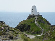
Tŵr Mawr Lighthouse
This article needs additional citations for verification. (January 2017) |
 Tŵr Mawr lighthouse | |
 | |
| Location | Ynys Llanddwyn Anglesey Wales United Kingdom |
|---|---|
| Coordinates | 53°08′07″N 4°24′56″W / 53.135165°N 4.415574°W |
| Tower | |
| Constructed | 1845 |
| Construction | stone tower |
| Height | 11 metres (36 ft) |
| Shape | massive conical tower and roof |
| Markings | white tower |
| Operator | Llanddwyn Island National Nature Reserve [1] [2] |
| Heritage | Grade II listed building |
| Light | |
| Deactivated | 1975 |
| Focal height | 25 metres (82 ft) |
| Range | 7 nautical miles (13 km; 8.1 mi) |
Tŵr Mawr lighthouse (meaning "great tower" in Welsh), on Ynys Llanddwyn on Anglesey, Wales, marks the western entrance to the Menai Strait.
History
[edit]The 1873 tower is tapered in a style characteristic of Anglesey windmills. It is 33 feet (10 m) high and 18 feet (5.5 m) in diameter. It may have been constructed by an Anglesey stone mason, and it is possible that the tower itself was originally used as a windmill. The light did not revolve, but projected a fixed beam through a ground-floor window. The higher floors in the tower provided accommodation.[3]
The lantern and fittings cost £250 7s 6d, including the adaptation of an "earlier tower". The north-east door is flanked by small windows, and the two floors above also have small windows, but the top does not. The conical roof is slated and has a flagpole. The present lantern window is about 6 feet 6 inches (1.98 m) by 2 feet (0.61 m). The optic, silver-plated reflector and Fresnel lens are dated 1861 and were used into the 1970s. The lantern was originally lit by six Argand lamps with reflectors.
A smaller, conical tower, with a domed top, is located to the south-east, and may be an earlier structure. The walls are 6 feet 8 inches (2.03 m) in radius and 3 feet (0.91 m) thick, with a door to the north-west, and show signs of cracking to the rubble-filled walls on the west.
Neither tower is shown on the chart of Lewis Morris, dated 1800, but they both appear on the Ordnance Survey 1818-1823 2 inches/mile map. They both probably originated as unlit markers. The cottages nearby have been used as craft workshops, and the local community here once serviced pilot-boats and lifeboats.

Replacement
[edit]In 1975 the function of the Tŵr Mawr lighthouse was taken over by the nearby Tŵr Bach ("Little Tower") lighthouse (53°08′03″N 4°24′46″W / 53.1343°N 4.4129°W).[3]
See also
[edit]References
[edit]- ^ Rowlett, Russ. "Lighthouses of Wales". The Lighthouse Directory. University of North Carolina at Chapel Hill. Retrieved 1 June 2016.
- ^ Twr Mawr Light Lighthouse Explorer. Retrieved 1 June 2016
- ^ a b O'Reilly, Roger (9 April 2024). Legendary Lighthouses of Britain. Watkins Media Limited. ISBN 978-1-78678-812-2.
External links
[edit]
