Sulejów
Sulejów | |
|---|---|
 | |
| Coordinates: 51°21′10″N 19°53′5″E / 51.35278°N 19.88472°E | |
| Country | |
| Voivodeship | Łódź |
| County | Piotrków |
| Gmina | Sulejów |
| First mentioned | 1145 |
| Town rights | 13th century |
| Government | |
| • Mayor | Dorota Jankowska |
| • Chairman of the Town Council | Rafał Kulbat |
| Area | |
• Total | 26.25 km2 (10.14 sq mi) |
| Population (31 December 2020) | |
• Total | 6,130 |
| Time zone | UTC+1 (CET) |
| • Summer (DST) | UTC+2 (CEST) |
| Postal code | 97-330 |
| Vehicle registration | EPI |
| National roads | |
| Website | http://www.sulejow.pl |
Sulejów [suˈlɛjuf] is a town in central Poland with 6,130 inhabitants (2020).[1] It is situated in Łódź Voivodeship. Sulejów gives its name to the protected area known as Sulejów Landscape Park.
History
[edit]
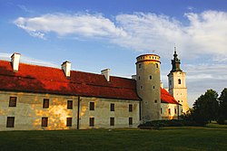
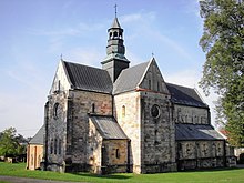
The origins of Sulejów are associated with a village founded near the crossing of the Pilica river in the 12th century. The castle, which later sparked the development of a Cistercian abbey, was built between 1176 and 1177, on the orders of Duke Casimir II the Just. The abbey was constructed in the place which is now called Podklasztorze. Sulejów received its town rights in the middle of the 13th century, later confirmed by King Władysław I the Elbow-high.
A great event in the history of the town was a rally, which took place between 20 and 23 of June, 1318. This rally was the official ceremony of adopting and enacting the papal conditions and the resumption of the Polish Kingdom. A permission request was sent to Pope John XXII for the coronation of Władysław I the Elbow-high. Later Kuyavian Bishop Gerward was sent to Avignon for negotiations.
Sulejów used to be located on the trade routes between Silesia, Wielkopolska and the Kievan Rus'. In 1410 the Cistercian abbey was one of the stopping places for the Polish army, led by King Władysław II Jagiełło. Also Kings Casimir IV Jagiellon and John II Casimir Vasa and several papal legates visited the town.[2] Sulejów was a private church town, administratively located in the Piotrków County in the Sieradz Voivodeship in the Greater Poland Province of the Kingdom of Poland.[3]

The town was damaged by the Swedes in 1655 during the Deluge,[4] which caused the collapse of the town. As a result of the Third Partition of Poland (1795), the town was divided between Prussia and Austria.[4] In 1807–1809 it was regained by Poles and included within the short-lived Duchy of Warsaw, and in 1815 it fell to the Russian Partition of Poland. In 1819, the Cistercian monastery was closed. During the January Uprising, Polish insurgents and Russian troops clashed in Sulejów on April 4, 1863.[5] In 1870 Sulejów was deprived of its town rights by the Tsarist administration, as one of many towns punished for the Polish January Uprising. After World War I, in 1918, Poland regained independence and control of Sulejów, and in 1927 town rights were restored, which has contributed to the faster development of Sulejów.
Further destruction of the town occurred on 4 September 1939, during the German Luftwaffe bombing in time of the invasion of Poland which started World War II. As a result, 80% of the buildings, including the Old Town, were destroyed. That day almost 1,000 people died.[6][7] The town then fell under German occupation until 1945. In mid-1940 the German police carried out mass arrests of over 100 Poles, including teachers, judges and students of secret Polish schools.[8]
After World War II, the town was partially rebuilt. From 1975 to 1998 it was located in Piotrków Voivodeship. In 1986 the Cistercians returned to the newly reopened monastery.
Climate
[edit]Sulejów has an oceanic climate (Köppen climate classification: Cfb) using the −3 °C (27 °F) isotherm or a humid continental climate (Köppen climate classification: Dfb) using the 0 °C (32 °F) isotherm.[9][10]
| Climate data for Sulejów (1991–2020 normals, extremes 1961–present) | |||||||||||||
|---|---|---|---|---|---|---|---|---|---|---|---|---|---|
| Month | Jan | Feb | Mar | Apr | May | Jun | Jul | Aug | Sep | Oct | Nov | Dec | Year |
| Record high °C (°F) | 14.0 (57.2) |
18.1 (64.6) |
22.7 (72.9) |
29.9 (85.8) |
31.2 (88.2) |
35.9 (96.6) |
36.5 (97.7) |
38.0 (100.4) |
35.2 (95.4) |
26.0 (78.8) |
18.8 (65.8) |
15.3 (59.5) |
38.0 (100.4) |
| Mean daily maximum °C (°F) | 1.1 (34.0) |
2.8 (37.0) |
7.3 (45.1) |
14.4 (57.9) |
19.4 (66.9) |
22.6 (72.7) |
25.2 (77.4) |
25.0 (77.0) |
19.2 (66.6) |
13.2 (55.8) |
6.8 (44.2) |
2.3 (36.1) |
13.3 (55.9) |
| Daily mean °C (°F) | −1.7 (28.9) |
−0.5 (31.1) |
2.9 (37.2) |
8.7 (47.7) |
13.5 (56.3) |
16.9 (62.4) |
19.0 (66.2) |
18.6 (65.5) |
13.6 (56.5) |
8.5 (47.3) |
3.8 (38.8) |
−0.2 (31.6) |
8.6 (47.5) |
| Mean daily minimum °C (°F) | −4.3 (24.3) |
−3.6 (25.5) |
−1.0 (30.2) |
3.1 (37.6) |
7.7 (45.9) |
11.1 (52.0) |
13.0 (55.4) |
12.6 (54.7) |
8.6 (47.5) |
4.7 (40.5) |
1.0 (33.8) |
−2.6 (27.3) |
4.2 (39.6) |
| Record low °C (°F) | −32.2 (−26.0) |
−30.6 (−23.1) |
−25.1 (−13.2) |
−7.2 (19.0) |
−3.8 (25.2) |
−0.4 (31.3) |
0.0 (32.0) |
1.7 (35.1) |
−3.4 (25.9) |
−8.0 (17.6) |
−18.2 (−0.8) |
−28.3 (−18.9) |
−32.2 (−26.0) |
| Average precipitation mm (inches) | 30.6 (1.20) |
28.5 (1.12) |
34.1 (1.34) |
38.5 (1.52) |
64.0 (2.52) |
73.8 (2.91) |
84.6 (3.33) |
58.1 (2.29) |
50.9 (2.00) |
41.8 (1.65) |
35.6 (1.40) |
32.3 (1.27) |
572.8 (22.55) |
| Average extreme snow depth cm (inches) | 7.0 (2.8) |
6.4 (2.5) |
4.6 (1.8) |
1.6 (0.6) |
0.1 (0.0) |
0.0 (0.0) |
0.0 (0.0) |
0.0 (0.0) |
0.0 (0.0) |
0.2 (0.1) |
2.3 (0.9) |
3.9 (1.5) |
7.0 (2.8) |
| Average precipitation days (≥ 0.1 mm) | 16.20 | 14.24 | 14.13 | 12.07 | 13.83 | 13.67 | 14.43 | 11.97 | 11.93 | 13.10 | 14.45 | 16.13 | 166.16 |
| Average snowy days (≥ 0 cm) | 15.5 | 14.7 | 7.2 | 1.2 | 0.0 | 0.0 | 0.0 | 0.0 | 0.0 | 0.3 | 4.2 | 10.0 | 53.1 |
| Average relative humidity (%) | 86.8 | 84.1 | 78.3 | 70.8 | 72.3 | 73.4 | 72.6 | 72.3 | 79.3 | 84.2 | 88.6 | 88.6 | 79.3 |
| Mean monthly sunshine hours | 53.0 | 71.6 | 125.5 | 188.4 | 243.1 | 245.7 | 251.5 | 244.8 | 165.1 | 111.7 | 53.1 | 42.0 | 1,795.4 |
| Source 1: Institute of Meteorology and Water Management[11][12][13][14][15][16][17][18] | |||||||||||||
| Source 2: Meteomodel.pl (records, relative humidity 1991–2020)[19][20][21] | |||||||||||||
Demographics
[edit]| Year | Pop. | ±% |
|---|---|---|
| 1890 | 4,027 | — |
| 1897 | 4,636 | +15.1% |
| 1910 | 5,284 | +14.0% |
| 1921 | 5,718 | +8.2% |
| 1931 | 6,387 | +11.7% |
| 1939 | 7,048 | +10.3% |
| 1950 | 3,873 | −45.0% |
| 1960 | 4,854 | +25.3% |
| 2010 | 6,418 | +32.2% |
| Source: [22][23] | ||
References
[edit]- ^ a b "Local Data Bank". Statistics Poland. Retrieved 7 November 2021. Data for territorial unit 1010094.
- ^ Słownik geograficzny Królestwa Polskiego i innych krajów słowiańskich, Tom XI (in Polish). Warszawa. 1890. p. 567.
{{cite book}}: CS1 maint: location missing publisher (link) - ^ Atlas historyczny Polski. Województwo sieradzkie i województwo łęczyckie w drugiej połowie XVI wieku. Część I. Mapy, plany (in Polish). Warszawa: Instytut Historii Polskiej Akademii Nauk. 1998. p. 4.
- ^ a b Słownik geograficzny Królestwa Polskiego i innych krajów słowiańskich, Tom XI, p. 565
- ^ Zieliński, Stanisław (1913). Bitwy i potyczki 1863-1864. Na podstawie materyałów drukowanych i rękopiśmiennych Muzeum Narodowego w Rapperswilu (in Polish). Rapperswil: Fundusz Wydawniczy Muzeum Narodowego w Rapperswilu. p. 28.
- ^ Martin Gilbert The Holocaust Fontana, 1990 ISBN 0-00-637194-9 Page 85
- ^ History of Sulejów
- ^ Wardzyńska, Maria (2009). Był rok 1939. Operacja niemieckiej policji bezpieczeństwa w Polsce. Intelligenzaktion (in Polish). Warszawa: IPN. p. 266.
- ^ Kottek, Markus; Grieser, Jürgen; Beck, Christoph; Rudolf, Bruno; Rubel, Franz (2006). "World Map of the Köppen-Geiger climate classification updated" (PDF). Meteorologische Zeitschrift. 15 (3): 259–263. Bibcode:2006MetZe..15..259K. doi:10.1127/0941-2948/2006/0130.
- ^ Peel, M. C.; Finlayson B. L. & McMahon, T. A. (2007). "Updated world map of the Köppen–Geiger climate classification" (PDF). Hydrol. Earth Syst. Sci. 11 (5): 1633–1644. doi:10.5194/hess-11-1633-2007. ISSN 1027-5606.
- ^ "Średnia dobowa temperatura powietrza". Normy klimatyczne 1991-2020 (in Polish). Institute of Meteorology and Water Management. Archived from the original on 3 December 2021. Retrieved 22 February 2022.
- ^ "Średnia minimalna temperatura powietrza". Normy klimatyczne 1991-2020 (in Polish). Institute of Meteorology and Water Management. Archived from the original on 15 January 2022. Retrieved 22 February 2022.
- ^ "Średnia maksymalna temperatura powietrza". Normy klimatyczne 1991-2020 (in Polish). Institute of Meteorology and Water Management. Archived from the original on 15 January 2022. Retrieved 22 February 2022.
- ^ "Miesięczna suma opadu". Normy klimatyczne 1991-2020 (in Polish). Institute of Meteorology and Water Management. Archived from the original on 9 January 2022. Retrieved 22 February 2022.
- ^ "Liczba dni z opadem >= 0,1 mm". Normy klimatyczne 1991-2020 (in Polish). Institute of Meteorology and Water Management. Archived from the original on 15 January 2022. Retrieved 22 February 2022.
- ^ "Średnia grubość pokrywy śnieżnej". Normy klimatyczne 1991-2020 (in Polish). Institute of Meteorology and Water Management. Archived from the original on 15 January 2022. Retrieved 22 February 2022.
- ^ "Liczba dni z pokrywą śnieżna > 0 cm". Normy klimatyczne 1991-2020 (in Polish). Institute of Meteorology and Water Management. Archived from the original on 21 January 2022. Retrieved 22 February 2022.
- ^ "Średnia suma usłonecznienia (h)". Normy klimatyczne 1991-2020 (in Polish). Institute of Meteorology and Water Management. Archived from the original on 15 January 2022. Retrieved 22 February 2022.
- ^ "Sulejów Absolutna temperatura maksymalna" (in Polish). Meteomodel.pl. 6 April 2018. Retrieved 22 February 2022.
- ^ "Sulejów Absolutna temperatura minimalna" (in Polish). Meteomodel.pl. 6 April 2018. Retrieved 22 February 2022.
- ^ "Sulejów Średnia wilgotność" (in Polish). Meteomodel.pl. 6 April 2018. Retrieved 22 February 2022.
- ^ Dokumentacja Geograficzna (in Polish). Vol. 3/4. Warszawa: Instytut Geografii Polskiej Akademii Nauk. 1967. p. 49.
- ^ Stan i struktura ludności oraz ruch naturalny w przekroju terytorialnym w 2010 r. (PDF) (in Polish). Warszawa: Główny Urząd Statystyczny. 2011. p. 64. Archived from the original (PDF) on 13 November 2011.
Lua error in Module:Navbox at line 535: attempt to get length of local 'arg' (a number value).


