Stewart, Indiana
Appearance
Stewart, Indiana | |
|---|---|
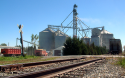
 Grain elevators at harvest time, October 2006 | |
| Coordinates: 40°21′36″N 87°28′21″W / 40.36000°N 87.47250°W | |
| Country | United States |
| State | Indiana |
| County | Warren |
| Township | Jordan |
| Elevation | 712 ft (217 m) |
| Time zone | UTC-5 (Eastern (EST)) |
| • Summer (DST) | UTC-4 (EDT) |
| ZIP code | 47993 |
| Area code | 765 |
| GNIS feature ID | 444145[1] |
Stewart is a small unincorporated community in Jordan Township, Warren County, in the U.S. state of Indiana.[1] It sits at the south end of the short Bee Line Railroad and consists of a single residence and a grain elevator operated by the Stewart Grain Company. The original elevator, built in 1905 and rebuilt in 1910 after a fire, still stands although it was moved 500 feet to a non-working location in 2009 for historical and sentimental reasons.
Geography
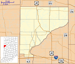
[edit]Stewart is located at the intersection of County Road 300 North and the Bee Line Railroad, about two miles directly east of Pence.
References
[edit]Warren County Historical Society. A History of Warren County, Indiana (175th Anniversary Edition) (2002).


