Ski Butternut
Appearance
| Ski Butternut | |
|---|---|
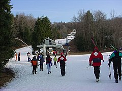
 The Top Flight Quad at Ski Butternut | |
| Location | Great Barrington, Massachusetts, US |
| Coordinates | 42°10′41″N 73°19′01″W / 42.17806°N 73.31694°W |
| Vertical | 1,000 ft (300 m)[1] |
| Top elevation | 1,800 ft (550 m) |
| Base elevation | 820 ft (250 m) |
| Trails | 22 |
| Longest run | Pied Piper, to Crosstown, and then to cruiser. |
| Lift system | 4 Chair lift, including 4 carpet lifts. |
| Terrain parks | 2 |
| Snowfall | 115 in (292 cm)[2] |
| Snowmaking | 100% |
| Website | Ski Butternut |
Ski Butternut, also known as Butternut Basin, is a ski resort in Great Barrington, Massachusetts, US, on Warner Mountain in The Berkshires.
Channing and Jane Murdock took control of the area in 1963, naming the area Butternut Basin after the large groves of butternut trees in the basin of the mountain. The Kennedys, family friends of the Murdocks, visited Butternut. [failed verification][3][4]
The mountain has 22 trails, ten ski lifts including three quad lifts, two terrain parks, an area for tubing in winter, and a PSIA-affiliated ski school. In the off-season, the mountain hosts a number of summer concerts and festivals, including the annual Berkshires Arts Festival.
References
[edit]- ^ Ski Butternut Ski Reports, Snow Conditions and Weather - SnoCountry Mountain Reports
- ^ "Ski Butternut Ski Resort Area Overview - OnTheSnow".
- ^ Brief history from Butternut Basin's 2003 Fortieth Anniversary Brochure
- ^ Brief History of Jug End Ski Area, South Egremont, MA, on "New England History" website.
External links
[edit]- Ski Butternut - Official site
- G-Bar-S Ranch - New England Lost Ski Areas Project
- Butternut - NewEnglandSkiHistory.com - Ski area and CCC trails history
Categories:
- Buildings and structures in Berkshire County, Massachusetts
- Great Barrington, Massachusetts
- Ski areas and resorts in Massachusetts
- Sports in Berkshire County, Massachusetts
- Tourist attractions in Berkshire County, Massachusetts
- Ski area and resort stubs
- Berkshire County, Massachusetts, geography stubs
- Massachusetts building and structure stubs
- Northeastern United States sports venue stubs
- Massachusetts sport stubs
