Seo District, Daejeon
Seo
서구 | |
|---|---|
| Korean transcription(s) | |
| • Hanja | 西區 |
| • Revised Romanization | Seo-gu |
| • McCune–Reischauer | Sŏ-gu |
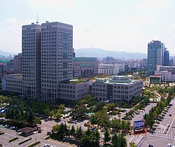
 Daejeon City Hall and nearby Dunsan area | |
 | |
| Country | South Korea |
| Region | Hoseo |
| Provincial level | Daejeon |
| Administrative divisions | 23 administrative dong |
| Government | |
| • Mayor | Seo Cheol-Mo (People Power) |
| Area | |
• Total | 95.25 km2 (36.78 sq mi) |
| Population (2024[1]) | |
• Total | 458,903 |
| • Density | 4,800/km2 (12,000/sq mi) |
| • Dialect | Chungcheong |
| Website | Seo District Office |
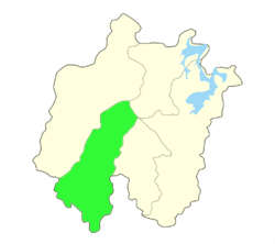
Seo District (Korean: 서구; RR: Seo-gu) is a gu ("district") of Daejeon, South Korea. Daejeon Metropolitan City Hall is also located there.This is a self-governing district located in the southwestern part of Daejeon Metropolitan City. It serves as the central hub of the city, hosting several major developments such as Dunsan New Town, Gwanjeo District, and Doan New Town. With a population of approximately 470,000, it is the most populous district in Daejeon, accounting for about one-third of the city’s total population.
Administrative divisions
[edit]Seo-gu is divided into 14 dong (동, "neighborhoods"):
- Gasuwon-dong
- Gwanjeo-dong
- Giseong-dong
- Wolpyeong-dong
- Nae-dong
- Gajang-dong
- Goejeong-dong
- Dunsan-dong
- Sancheon-dong
- Tanbang-dong
- Yongmun-dong
- Byeon-dong
- Boksu-dong
- Doma-dong
Places of interest
[edit]Dunsan-dong is one of the more densely populated areas of Daejeon. As a result, it is the location of several points of interest. These include department stores, government offices, and several international chain restaurants and retailers. There is Pai Chai University in Seo District, Daejeon. There is also Hanbat Arboretum. There is also the "Cafe Wave". There is an Art Center. Jangtae Recreational Forest is located in the district.
Also, Daejeon Arts Center, a representative general concert hall in Daejeon, is also located in Seo-gu.
Education
[edit]Higher Education
[edit]- Korea Advanced Institute of Science and Technology(KAIST)
- Daejeon Institute of Science and Technology
- Mokwon University
- PAI CHAI University
High School
[edit]Middle School
[edit]See also
[edit]References
[edit]- ^ "Population statistics". Korea Ministry of the Interior and Safety. 2024.
External links
[edit]- Official website (in English)
36°21′N 127°23′E / 36.35°N 127.38°E

