Scherwiller
You can help expand this article with text translated from the corresponding article in French. (December 2008) Click [show] for important translation instructions.
|
Scherwiller | |
|---|---|
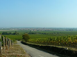
 The village viewed from the vineyard | |
| Coordinates: 48°17′18″N 7°25′07″E / 48.2883°N 7.4186°E | |
| Country | France |
| Region | Grand Est |
| Department | Bas-Rhin |
| Arrondissement | Sélestat-Erstein |
| Canton | Sélestat |
| Intercommunality | Sélestat |
| Government | |
| • Mayor (2020–2026) | Olivier Sohler[1] |
Area 1 | 18.08 km2 (6.98 sq mi) |
| Population (2022)[2] | 3,121 |
| • Density | 170/km2 (450/sq mi) |
| Time zone | UTC+01:00 (CET) |
| • Summer (DST) | UTC+02:00 (CEST) |
| INSEE/Postal code | 67445 /67750 |
| Elevation | 168–532 m (551–1,745 ft) |
| 1 French Land Register data, which excludes lakes, ponds, glaciers > 1 km2 (0.386 sq mi or 247 acres) and river estuaries. | |
Scherwiller (French pronunciation: [ʃɛʁvilɛʁ]; German: Scherweiler) is a commune in the Bas-Rhin department in Alsace in northeastern France.[3]
Geography
[edit]The town is situated on the wine route at an altitude of 185 meters (607 ft). Scherwiller is located at the mouth of the valleys of Sainte-Marie-aux-Mines to the east, and Villé at north, 5 kilometers (3.1 mi) west of Sélestat, Center Alsace, and 3.5 km (2.2 mi) south of Châtenois.
Population
[edit]| Year | Pop. | ±% p.a. |
|---|---|---|
| 1968 | 2,300 | — |
| 1975 | 2,368 | +0.42% |
| 1982 | 2,382 | +0.08% |
| 1990 | 2,278 | −0.56% |
| 1999 | 2,614 | +1.54% |
| 2007 | 3,009 | +1.77% |
| 2012 | 3,136 | +0.83% |
| 2017 | 3,195 | +0.37% |
| Source: INSEE[4] | ||
Residents are referred to as Scherwillerois in French.
History
[edit]The name was mentioned early in the form Sceravillare or Scerwiller, designating a hamlet on the edge of the Scheer, the former name of the Aubach River, which runs through the village. Scherwiller is located at the intersection of two Roman roads: on an east–west axis the salt road from the Villé Valley, and on a north–south axis a Roman road, two milestones of which are still identifiable in the town itself. This explains the presence of Ortenbourg Castle during the 12th century.
Economy
[edit]Located in the heart of Alsace, the village is built in the middle of a 300-hectare (740-acre) vineyard, extending along the slopes downwards from Ortenbourg and Ramstein castles.
See also
[edit]References
[edit]- ^ "Répertoire national des élus: les maires" (in French). data.gouv.fr, Plateforme ouverte des données publiques françaises. 13 September 2022.
- ^ "Populations de référence 2022" (in French). The National Institute of Statistics and Economic Studies. 19 December 2024.
- ^ INSEE commune file
- ^ Population en historique depuis 1968, INSEE


