Calabanga
This article needs additional citations for verification. (January 2013) |
Calabanga | |
|---|---|
| Municipality of Calabanga | |
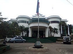 Municipal Hall | |
| Nickname: The True Heart of CamSur | |
| Motto(s): Saro sa Pagtubod, Saro sa Pag-asenso! | |
| Anthem: Calabanga March | |
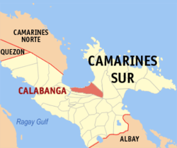 Map of Camarines Sur with Calabanga highlighted | |
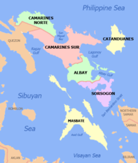
Location within the Philippines | |
| Coordinates: 13°42′32″N 123°12′58″E / 13.7089°N 123.2161°E | |
| Country | Philippines |
| Region | Bicol Region |
| Province | Camarines Sur |
| District | 3rd district |
| Founded | 1578 (Quipayo) 1756 (Calabanga) |
| Barangays | 48 (see Barangays) |
| Government | |
| • Type | Sangguniang Bayan |
| • Mayor | Eugene Severo |
| • Vice Mayor | Victor B. de Villa |
| • Representative | Gabriel H. Bordado Jr. |
| • Municipal Council | Members |
| • Electorate | 56,664 voters (2022) |
| Area | |
• Total | 163.80 km2 (63.24 sq mi) |
| Elevation | 13 m (43 ft) |
| Highest elevation | 94 m (308 ft) |
| Lowest elevation | −2 m (−7 ft) |
| Population (2020 census)[3] | |
• Total | 88,906 |
| • Density | 540/km2 (1,400/sq mi) |
| • Households | 19,444 |
| Economy | |
| • Income class | 1st municipal income class |
| • Poverty incidence | 38.07 |
| • Revenue | ₱ 279.2 million (2020) |
| • Assets | ₱ 553.5 million (2020) |
| • Expenditure | ₱ 202.5 million (2020) |
| • Liabilities | ₱ 221.3 million (2020) |
| Service provider | |
| • Electricity | Camarines Sur 2 Electric Cooperative (CASURECO 2) |
| Time zone | UTC+8 (PST) |
| ZIP code | 4405 |
| PSGC | |
| IDD : area code | +63 (0)54 |
| Native languages | Central Bikol Tagalog |
| Website | www |
Calabanga, officially the Municipality of Calabanga (Central Bikol: Banwaan kan Calabanga; Tagalog: Bayan ng Calabanga), is a municipality in the province of Camarines Sur, Philippines. According to the 2020 census, it has a population of 88,906 people.[3][5]
History
[edit]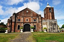
In 1578 when the head Mission of Quipayo was established, Calabanga was only a visita or barrio. At that time, the place had vast forests and swamps and an abundance of wildlife such as monkeys, wild chickens, and forest lizard. Others say, it derived its name from the Bicol word “Calabangan”, the plural term of “labang” or “litag”, meaning a kind of snare for catching wild animals. Another legend says that Calabanga originated from the word “Calagbangan” meaning the wide, long, and straight street spanning from the church through the poblacion, east to west, called locally as “calabaan” or “calacbangan”.
Calabanga became known with 400 tributes. On July 15, 1749, it was separated from Quipayo by virtue of the approval of Don Fray Joan de Arechera, Bishop Elect of Nueva Segovia of the Commissary of the King, in the petition signed & filed by 37 Calabangueños on April 28, 1749, for town to be conveniently administered.
There were 2 visitas, visita de Cagapad and visita de hinarijan and 12 barrios. The barrios were san Antonio, San Vicente, Santa Catalina, Nuestra Señora de Salud, San Lucas, San Miguel, Santa Isabel, Nuestra Señora del Carmen, San Roque, San Pablo, San Jose (now Balongay) and Belen.
Calabanga is one of the municipalities of the province of Camarines Sur and a member of the Metro Naga Development Council. With its fishing grounds and the vast agricultural area, it is a major supplier of fish and other marine products and prime agricultural products in the province as well as in Metro Manila.[6]
Quipayo or Calabanga used to own Tinambak (Tinambac), Masirum (Siruma), Bombon, Magarao, Cabusao, and Piglabanan (Libmanan). Libmanan is the oldest that was established in 1580 while Bombon was the last being separated which was created in 1949.
Cityhood
[edit]Attaining a steady progress through time, the fishing town is now preparing to be the next chartered city in the province of Camarines Sur. This is through the Executive Order No. 25, Series of 2021 on October 25, 2021, which created the "Calabanga Cityhood Committee" headed by Mayor Eduardo A. Severo. Calabanga will be known as "The sardine capital of Bicol". If so Calabanga will be the 4th city in Camarines Sur after Naga, Iriga and Pili.[7]
Geography
[edit]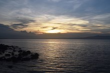
Calabanga has a land area of 16,380 hectares (40,500 acres), which constitutes 3.1% of the Camarines Sur's land area. It is bounded on the west by the Bicol River and beyond the municipality of Cabusao; on the south by the municipality of Bombon and Naga City; on the east by the forest lands of Mount Isarog, the Tigman River and each tributary forming the natural boundary and beyond the municipality of Tinambac; on the north by the fishing grounds of San Miguel Bay, and beyond, the municipalities of Sipocot, Basud and Mercedes.
Calabanga is divided into six areas:
Topography and slope
[edit]The topographic landscape of the municipality could be characterized as generally flat with a slope 0-3%, gently sloping (3-8%) towards the direction of the eastern portion and finally rolling up to higher steeps towards the direction of the south-eastern part going to Mt. Isarog. The 0-3% slope is a broad area of flat to nearly level land which extends from Barangay Balongay along the Bicol River to Poblacion area and surrounding areas down to Barangay Manguiring. This is the dominant slope of the municipality.
Soil and water resources
[edit]There are six soil types that could be found in the Municipality. These are the (1) Hydrosol which is dominant along the Bicol River covering parts of Barangays Balongay, San Bernardino and Punta Tarawal; (2) Balong Clay; (3) Pili Clay Loam; (4) Tigaon Clay which covers the poblacion; (5) Annan Clay Loam which could be found toward the direction of Tinambac and (6) Mountain Soil in the Mt. Isarog area.
The municipality of Calabanga is endowed with abundant natural resources. The major river systems, the Tigman, Hinaguianan and Inarihan rivers are presently utilized for irrigation purposes. They originate their main tributaries from Mt. Isarog and flow down in the north-western direction ultimately discharging the flow to San Miguel Bay.
Calabanga is blessed with many natural spring water resources found in the eastern portion of the municipality along the north-western flanks of Mt. Isarog. Most of these are found to be potential sources for potable water supply of the municipality, aside from the Hamislag and Tawang rivers.
Calabanga is bounded by water bodies, the San Miguel Bay on the northern part and the Bikol River on the western part which are sources of abundant supplies of fish of various species and other marine products.
Land use
[edit]With its generally flat terrain, the dominant land use is agricultural. The built-up areas and major rivers have the smallest portion of the total area. Built-up areas are clustered within the urban barangays. The urban areas expand in an almost linear development or ribbon like development pattern.
Proposed land use as embodied in the comprehensive land use plan has delineated the residential, commercial, institutional area within the urban land use while the agricultural, agro-industrial, special use could be found in the general land use.
Barangays
[edit]Calabanga is politically subdivided into 48 barangays. Each barangay consists of puroks and some have sitios.
Currently, there are 14 of which located within the urban area while the remaining 34 barangays belong to the rural areas. It has 11 coastal barangays and 3 highly urbanized barangays.
- Balatasan
- Balombon
- Balongay
- Belen
- Bigaas
- Binanuaanan Grande
- Binanuaanan Pequeño
- Binaliw
- Bonot-Santa Rosa
- Bombon
- Burabod
- Cabanbanan
- Cagsao
- Camuning
- Comaguingking
- Del Carmen (Pob.)
- Dominorog
- Fabrica
- Harubay
- La Purisima (Quipayo)
- Lugsad
- Manguiring
- Pagatpat (Urban)
- Paolbo (Urban)
- Pinada
- Punta Tarawal (National Museum)
- Quinale
- Sabang (Urban)
- Salvacion-Baybay
- San Antonio Poblacion (Commercial Center)
- San Antonio (Quipayo)
- San Bernardino
- San Francisco (Municipal Hall)
- San Isidro (Market)
- San Lucas (Urban)
- San Miguel (Pob.)
- San Pablo (Pob.)
- San Roque (Urban)
- San Vicente (Pob.)
- Santa Cruz Poblacion (Urban)
- Santa Cruz (Quipayo)
- Santa Isabel (Pob.)
- Santa Salud (Pob.)
- Santo Domingo
- Santo Niño (Quipayo)
- Siba-o
- Sibobo
- Sogod
- Tomagodtod
Climate
[edit]| Climate data for Calabanga, Camarines Sur | |||||||||||||
|---|---|---|---|---|---|---|---|---|---|---|---|---|---|
| Month | Jan | Feb | Mar | Apr | May | Jun | Jul | Aug | Sep | Oct | Nov | Dec | Year |
| Mean daily maximum °C (°F) | 32 (90) |
31 (88) |
34 (93) |
36 (97) |
37 (99) |
37 (99) |
36 (97) |
34 (93) |
35 (95) |
34 (93) |
33 (91) |
32 (90) |
34 (94) |
| Mean daily minimum °C (°F) | 27 (81) |
27 (81) |
29 (84) |
31 (88) |
32 (90) |
32 (90) |
31 (88) |
30 (86) |
30 (86) |
29 (84) |
28 (82) |
28 (82) |
30 (85) |
| Average precipitation mm (inches) | 39.34 (1.55) |
68.7 (2.70) |
26.73 (1.05) |
66.19 (2.61) |
84.49 (3.33) |
178.89 (7.04) |
244.27 (9.62) |
188.3 (7.41) |
160.98 (6.34) |
445 (17.5) |
135.5 (5.33) |
367.8 (14.48) |
2,006.19 (78.96) |
| Average rainy days | 16 | 18 | 13 | 15 | 23 | 28 | 30 | 24 | 26 | 27 | 25 | 29 | 274 |
| Source: World Weather Online (Use with caution: this is modeled/calculated data, not measured locally.) [8] | |||||||||||||
Demographics
[edit]| Year | Pop. | ±% p.a. |
|---|---|---|
| 1903 | 7,563 | — |
| 1918 | 7,953 | +0.34% |
| 1939 | 15,087 | +3.10% |
| 1948 | 21,791 | +4.17% |
| 1960 | 28,467 | +2.25% |
| 1970 | 34,718 | +2.00% |
| 1975 | 40,274 | +3.02% |
| 1980 | 43,030 | +1.33% |
| 1990 | 54,261 | +2.35% |
| 1995 | 59,164 | +1.63% |
| 2000 | 67,408 | +2.84% |
| 2007 | 73,333 | +1.17% |
| 2010 | 78,119 | +2.33% |
| 2015 | 83,033 | +1.17% |
| 2020 | 88,906 | +1.35% |
| Source: Philippine Statistics Authority[9][10][11][12] | ||
In the 2020 census, the population of Calabanga was 88,906 people,[3] with a density of 540 inhabitants per square kilometre or 1,400 inhabitants per square mile.
In the 2020 PSA Survey, Calabanga had a total population of 88,906 with 35,088 or 39.5% belong to the urban population and 53,818 or 60.5% belong to the rural population. There was an increase of 5,873 over the 2015 population. The total population is distributed over 13,444 households, registering an increase of 1,371 households over the 1995 household of 11,073. The average household size in 2000 survey slightly goes up to 5.4 from 5.3 persons in 1995.
Between 1995 and 2000, Calabanga grew at the rate of 2.83%, higher than the 1990-1995 rate of 1.63%. As per the 2010 census, the municipal population density is 477 persons per km2.
Of the 48 barangays in the municipality, Barangay San Roque has the largest population of 5,513 people, composing 7.38% of the total population, followed by Barangay Santa Cruz Ratay with a population of 5,069 people. Barangay Punta Tarawal has the lowest population of 265 which only 0.44% of the total population.[10]
Despite the influx of various religious groups, a large segment which is 95.28% of the populace is still Roman Catholics. Most of the populace, 95.93% are Bicolano speaking.
Isarog Agta language
[edit]In 2010, UNESCO released its third world volume of Endangered Languages in the World, where three critically endangered languages were in the Philippines. One of these languages is the Isarog Agta language which has an estimated five speakers in the year 2000. The language was classified as Critically Endangered, meaning the youngest speakers are grandparents and older, and they speak the language partially and infrequently and hardly pass the language to their children and grandchildren anymore. If the remaining people do not pass their native language to the next generation of Isarog Agta people, their indigenous language will be extinct within a period of one to two decades.
The Isarog Agta people live within the circumference of Mount Isarog, though only five of them still know their indigenous language. They are one of the original Negrito settlers in the entire Philippines. They belong to the Aeta people classification, but have distinct language and belief systems unique to their own culture and heritage.
Urbanization
[edit]Calabanga, just of Naga City is rapidly urbanizing town with new infrastructures under construction in the Poblacion as well as the rural areas. It is the fourth most competitive town in Camarines Sur. The reason why the town is rapidly urbanizing is because people from the towns of Tinambac Bombon Siruma come there to work and study and another reason is its proximity to Naga City and also being part of the Metropolitan.
Economy
[edit]Poverty incidence of Calabanga
10
20
30
40
50
2006
38.80 2009
42.70 2012
33.38 2015
36.45 2018
26.78 2021
38.07 Source: Philippine Statistics Authority[13][14][15][16][17][18][19][20] |
Calabanga is the fifth largest commercial center in Camarines Sur next to Pili, followed by Libmanan and the 11th largest commercial center in Bicol Region next to Polangui and followed by Nabua. It became a 1st class municipality in October 2009.
Locally Source Revenue in ₱ (Millions)
2018: 19.46M
2019: 22.43M
2020: 26.97M
2021: 28.33M
2022: 37.09M
Economic history
[edit]During the very latter portion of the Spanish colonial period, Calabanga became larger than its mother town Quipayo which no longer exists today. Thousands of agricultural products are produced every day. The agriculture of the municipality became even more advanced during the American Colonial period. Calabanga started growing as an agricultural center that produces rice, corn, carrots, ginger, onions, potatoes, tomatoes, kang kong, horse radish and the famous sweet mangoes. In the 1930s the fishing industry got more attention from the local people and the Americans thus making Calabanga evolve as a fishing hub of Camarines Sur during that period, and it made Calabanga's economy thrive even more. During that time also a lot of natural resources were found on the highland areas of Calabanga to the southeast where the mount Isarog lies. The town did not commercialise until the 1960s. In 1968 where the first commercial establishment was the Severo shopping center (now defunct and is now the Angena Trading) was built in the Poblacion area marked the commercialisation of Calabanga's Centro area. Then in the following decades Calabanga did not only become an agricultural and fishing center in Camarines Sur but also a commercial center. The local economy of the municipality grew steadily during the late 80s till the early 2010s. Now a lot of establishments have opened in the town such as banks, malls, restaurants, stores, and financial institutions.
General economy
[edit]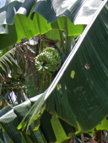
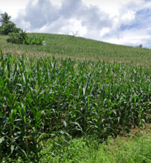
Calabanga is blessed with rich natural resources. It has big uplands and vast fishing grounds. Agricultural areas are the most extensive areas covering more than half of the total land area in this municipality. It is the dominant land use. Land devoted to crop production is approximately 7,609.79 ha. Which include rice, corn and coconut as the major crops and other crops such as abaca, coffee, vegetables, rootcrops and fruit trees. Calabanga's best export here is corn which Calabanga boasts the largest cornfield in the southern Luzon (Regions IV-A&B, Region V) which encompasses 12 barangays near mount Isarog one of which is Harubay.
Side by side with agriculture, fishing and livestock raising constitutes major economic activities. The fish grounds of San Miguel Bay as well as the Bikol River are the rich sources of plentiful fish, shellfish, oysters, capiz shells, prawns, shrimps and other marine species providing various livelihood industries such as fish processing, fish paste and bagoong making and other marine by-product. These marine by-products as well as shrimps, prawn, mudcrabs are supplied to the city of Naga, other neighboring provinces as well as in Manila. Other water sources include Inarihan, Tigman and Hinaguinan river aside from the fishponds for the brackish and freshwater species.
Livestock raising is a thriving industry in the municipality, an inventory of livestock and poultry farms shows that there are five commercial piggery and three commercial poultry farms operating in the municipality aside from the backyard animal raising which is very common in rural areas.
Next to agriculture and fishing, commerce, trade and industry are important and significant aspects in the economy of the municipality. Commercial and industrial activities are more concentrated in the urban areas that include among others wholesale and retail trade, minor service centers, transport business, community and personal services, drugstores, agri-supplies, gasoline stations while industrial activities include rice milling, fish processing, bamboo craft, furniture making, garments, metal crafts, ice plant, welding and auto repair shops as well as other small enterprises. Nipa shingle production is also one industry predominant at western barangays where nipa swamps could be found. The products are sold not only within the municipality but to nearby towns and Naga City.
The presence of a new Calabanga Public Market which started operation last 1998 finally resolved the demands for a bigger marketing center, while cooperatives throughout the municipality are gradually developing its enterprises.
Shopping centers
[edit]The municipality is home to major shopping mall in the region, the LCC Mall Calabanga which is located in the poblacion of the town. Other major establishments in the center of the municipality are CitiTrends, Calabanga Town Center (which is adjacent to the market), Star Master Plaza, and Angena Supermarket also in the poblacion, and the small Quipayo Community Center which no longer exists today. It is a very promising that it is a progressive town however it still is heavily dependent on farm and fishing.
Banks
[edit]- Producer's Bank
- Landbank
- ARDCI Microfinance
- Rural Bank of Calabanga
- SEC Bank
- Bank of the Philippine Islands
- BDO Unibank. Inc
- Union bank
Trade
[edit]Calabanga is the center, or at least near the center of San Miguel Bay it is the source of income in the municipalities surrounding San Miguel Bay and also some parts of Camarines Norte particularly Basud and Mercedes. The municipality's economy and population changed dramatically in the past 10–13 years.
Poblacion Economic Zone (PEZ)
[edit]Poblacion Economic Zone is an economic zone in Calabanga between Barangay San Miguel and Santa Cruz Ratay. This area hosts a lot of business establishments ranging from low class eateries to high end restaurants. This is also called the Calabanga Urban Belt. It is often busy in this area. This is where restaurants, churches, parks, stadiums, cockpit arenas, municipal hall, museum, market, malls, banks, financial institution are found.
Calabanga CBD III project
[edit]Just before the National Elections in 2022. The Local Government Unit and the provincial government proposed a project named "Calabanga CBD 3". This was headed by Former Governor Migz Villafuerte and mayor Eduardo Severo. As of August 2022 a road project that stretches from the market to Casureco II is ongoing. The new CBD has a land of 596,543 m2 and will have Condominiums. The new municipal hall, police station, Calabanga high school and college, Calabanga Hospital, and other government buildings and malls will be built there. It is a very ambitious project for the people of Calabanga. The CBD will also have a large park with dining and bars just near the town proper. The New CBD is just adjacent to the market with a new bus terminal that will enhance transportation in the municipality. The Star Master Plaza Mall that is the first building in the CBD and the largest mall in Calabanga that opened on June 22, 2023. The CBD will be fully finished by 15 to 20 years. This project was headed by former Mayor Eduardo Severo with his mission and vision named "AmBisyon natin Calabanga 2040!"
Agriculture
[edit]Produces the following products:
Most people are farmers and fishermen.
Tourism
[edit]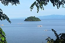
Calabanga has a quite a number of tourism potentials and attractions. Famous among the scenic beauties are the group of small islets/islands of Kawit, Tanglad, and Cabgan which is a few minutes from the shore. These islands are frequently visited by excursionists particularly during summer but these places need more development. Other places that invite picnickers to its cool and clear water are Tigman, Hinaguianan and Inarihan rivers and private commercial resorts.
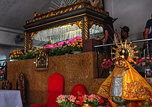
Historical sites worthy to see is the “Ladrillo” or a brick old church and ruins of Quipayo built sometime in 1578, more than four centuries ago, being the seat of the Catholic mission. Another is the “HINULID”, Santo Entiero shrine at Santa Salud which is an object of Friday devotion and pilgrimage. Thousands of devotees not only from Calabanga but other parts of Bicol Region and the country flock to the shrine during Maundy Thursday and Good Friday.
Calabanga also has apartments and condo buildings along the main street in Poblacion.
Culture
[edit]For sports and recreation, the municipality has a covered court at the poblacion area wherein the municipal-wide annual competitions for various sports activities such as basketball, volleyball and other sports are held. However, almost all barangays have multi-purpose play areas which are usually being utilized by the residents especially the youth, as volleyball and basketball courts. There is also a municipal park at the center of the poblacion area where people could spend their time and relax.
Government
[edit]Elected officials
[edit]| Position | Name of official |
|---|---|
| District Representative (3rd Legislative District, Camarines Sur) | Rep. Gabriel H. Bordado Jr. |
| Mayor | Eugene Norman B. Severo |
| Vice-Mayor | Victor B. de Villa |
| Councilors | Sherwin Francis O. Mendoza |
| Ruben Medroso III | |
| Ricardo A. Calisura | |
| Cielito Hilado | |
| Mike Bordado | |
| Pungay Tabinas | |
| Adonis Aguilar Jr. | |
| Roque Orlin |
Infrastructure
[edit]Highways
[edit]Calabanga only has one highway that traverses the municipality. It is the Naga North road or widely known as Naga - Siruma road. The highway starts at the boundary of Naga City in the intersection of Bagumbayan St, San Vicente Road and Capilihan St to Amuris Beach in Siruma.
Other roads are Pagatpat Road or diversion road and Balongay road.
Speaking of roads there is a new ongoing project from Casureco II station to the Local Market.
Others
[edit]Calabanga is endowed with abundant water resources. At present, the main source of local water district for potable water supply is from Balombon spring. Its capacity is 10 lps which is able to serve 18 barangays. The areas being served are San Antonio poblacion, Del Carmen, Sta Isabel, San Miguel, San Vicente, Santa Salud, San Lucas, San Pablo, San Francisco, Sta Cruz Poblacion, Paolbo, Manguiring, Balombon, San Roque, San Isidro, Pagatpat, Sabang and Salvacion Baybay. Most of these are in the poblacion areas and the rest are the barangays traversed by the source from Balombon.
For barangays not reach by the services of the Local Water District (Level III), the sources are shallow wells, deep wells and water peddlers. These serve the daily needs of the household for potable water supply.
All the barangays of the municipality are link by road system. The municipality is easily accessible from the City of Naga, Bicol Region's prime city. Most of the total road networks need improvements and rehabilitation to provide greater access to far-flung barangay residents and facilitate hauling and marketing of farm produce to the poblacion/ marketing centers.
For inter-barangay linkages, tricycles abound that could bring one to various barangay while foot pedalled tricycles/ padyak abound within the poblacion areas. For bus and jeepney parking facilities, there is a privately owned and operated terminal located at San Francisco but the local government has proposed integrated terminal that will be located within the Calabanga Public Market compound that could accommodate almost all jeepneys and tricycles in the municipality.
From Metro Manila, Calabanga is very much accessible via Naga City. First, by a 45-minute plane flight to Naga Airport located at Pili and a car/jeep ride of some 40 minutes to Calabanga. Another choice is a 7–10 hours aircon bus trip direct to Calabanga being provided by three bus lines. The Philippine National Railways (PNR) also provide trips from Manila to Bicol and vice- versa having a station at Naga City, then it takes some 20–30 minutes ride from Naga City to Calabanga.
The power supply in the municipality of Calabanga has been provided by the NAPOCOR through the Camarines Sur Electric Cooperative II (CASURECO II) since January 27, 1969 where the first lighting ceremony took off. At present, all the 48 barangays of the municipality are already served with electricity, however, few remaining sitios of far-flung barangays are still longing for the extension of power lines to their places. As of 2020 census 99.82% of Calabangueños have access to electricity.
Communication and technology
[edit]The modern technology on Communications and information has far reached the municipality of Calabanga and has provided the constituents with better access to communication.
Calabanga is being served by private telephone companies, the L.M. United Telephone Company (UNITEL) and the BAYANTEL Company which provides individual connections for those at the urban and outlying barangays. These companies provide local and long-distance calls to Metro Manila or any point in the country or any other place where the system can reach. Year 2002, the cellular mobile phone services within the municipality was improved and expanded through the installation of telecommunication facilities such as the cell site by two private telecommunication companies. The Bureau of Telecommunications, a government operated agency having a Telecom Office stationed in the municipality is providing telegraphic services to the residents of Calabanga while Postal services is provided mainly by the Philippine postal corporation.
According to the provincial government of Camarines Sur as of 2021 Calabanga has around 49,356 cellphone users and 30,057 people use internet.
Naga City TV relay stations as well as the cable TV stations are tuned-in in the municipality while a local cable TV station and a private; local community television station and a newly opened radio station are based in the municipality. Radio broadcasts from several radio stations in Canaman, and Naga City. Local as well as national newspapers and magazines are available regularly from newsstands and newsboys from Naga City.
Internet
[edit]Calabanga's main source of Internet is Converge which is owned by the government. However some households use PLDT, Globe Internet, Smart Bro, Talk N' Text Wifi and other private network companies.
Environment protection
[edit]Land protection
[edit]Eastern Calabanga which supplies water to the municipality and is within Mount Isarog, was declared as a protected landscape in 2018 by Former Mayor Eduardo Severo. Meaning no one should build houses or any establishments there. Subdivisions also cannot be built in the irrigated areas of Calabanga. This law was made through Republic Act 56 series of 2015.
Water protection
[edit]A lot of fishing accidents have happened in San Miguel Bay. These incidents include people from the Coastal Barangays of Calabanga throw their trash and feces in the bay. 1 fisherman killed tons of fish using chemicals in 2016 and was arrested due to the incident. So in 2017 the Municipal Government signed the Republic Act 24 series of 2017 which says people cannot throw feces and garbage in the bay of San Miguel. The Republic Act is in order to keep the water safe and clean.
Healthcare
[edit]Health facilities available are 24 private clinics (Medical & Dental), 7 Main and Rural Health Centers and 15 Pharmacies.
The number of health personnel is sufficient and beyond standard as to the ratio to the population, however, facilities and equipment are lacking which are compounded with the dilapidated main health center.
With the social welfare services devolved to the LGU as mandated under RA 7160, which is the Local Government Code of 1991, the municipality of Calabanga have assumed the responsibility of implementing the various programs such as the Child and Youth Welfare, Family and Community Organizing, Women's Welfare, Elderly and Disabled persons. Other services include family life education and counseling, Aid to individuals in Crisis Situation and emergency assistance which have the most number of clienteles. The municipality was able to establish and maintain 62-Day Care Centers located at 48 barangays.
For protective services, Barangay Tanod and Lupon Tagapamayapa were organized in every barangay and afforded appropriate training to help in keeping and maintaining peace and order and in setting disputes within and among barangay residents.
A new public municipal hospital will be constructed in Santa Cruz Ratay. This project is expected to start in Mid 2023. This will not only benefit people of Calabanga but also surrounding small towns.
Education
[edit]For education, the municipality has a high rate literacy which is attributed to the continuing efforts of the government to make education more accessible to the people. This is being maintained and improved through the 34 public elementary schools located in 32 places and 8 public secondary schools throughout the municipality aside from several private schools offering pre-school, grade school and high school. A college education and technical /vocational courses is being offered by two government-owned institutions the Calabanga Community College (formed under the administration of then Mayor Ruben B. Medroso) and The Central Bicol State University of Agriculture (Calabanga Campus) and privately owned computer schools.
The literacy rate in the municipality is high at 98.5%. The NSO survey in year 2000 for household population, 5 years old and over in terms of educational attainment, reflects the following; of the total population, 29,555 are in the elementary grade; 15,037 are in high school; only 2,623 or 0.045% of the population has no grade completed. 4, 446 are college under graduates with 1,057-degree holders and 201 with post baccalaureate degrees.
There are 38 public elementary schools in the entire municipality; eight high schools; one vocational and some five private schools that offer pre-school, grade school and high school. College education is being offered by two government-owned institutions, the Calabanga Community College and the Central Bicol State University of Agriculture (formerly: CSSAC - Calabanga Campus and privately owned computer Schools, one of which offer a multi-grade schooling from elementary to college levels (Malayan Computer College).
| Name of School | Address |
|---|---|
| Calabanga Central Division Pilot School | San Francisco, Calabanga, Camarines Sur |
| Calabanga National High School | Santa Cruz Poblacion, Calabanga, Camarines Sur |
| Calabanga West Central School | San Francisco, Calabanga, Camarines Sur |
| Central Bicol State University of Agriculture-Calabanga | Santa Cruz, Calabanga, Camarines Sur |
| Central Bicol State University of Agriculture Laboratory High School Calabanga Campus | Santa Cruz Poblacion, Calabanga, Camarines Sur |
| Balatasan Elementary School | Balatasan, Calabanga, Camarines Sur |
| Balombon Elementary School | Balombon, Calabanga, Camarines Sur |
| Balongay Elementary School | Balongay, Calabanga, Camarines Sur |
| Binaliw Elementary School | Binaliw, Calabanga, Camarines Sur |
| Binanuaanan Grande Elementary School | Binanuaanan Grande, Calabanga, Camarines Sur |
| Binanuanan Pequeño Elementary School | Binanuaanan Pequeño, Calabanga, Camarines Sur |
| Burabod Elementary School | Burabod, Calabanga, Camarines Sur |
| Cagsao Elementary School | Cagsao, Calabanga, Camarines Sur |
| Calabanga Community College | Santa Cruz Poblacion, Calabanga, Camarines Sur |
| Camuning Elementary School | Camuning, Calabanga, Camarines Sur |
| Comaguingking Elementary School | Comaguingking, Calabanga, Camarines Sur |
| Dominican School of Calabanga | San Francisco, Calabanga, Camarines Sur |
| Dominorog Elementary School | Dominorog, Calabanga, Camarines Sur |
| Escuela de la Salud | Sta. Salud, Calabanga, Camarines Sur |
| Fabrica Elementary School | Fabrica, Calabanga, Camarines Sur |
| G. Dumalasa Elementary School | Bonot Santa Rosa, Calabanga, Camarines Sur |
| Hansel and Gretel Learning School | San Isidro, Calabanga, Camarines Sur |
| Harubay Elementary School | Harubay, Calabanga, Camarines Sur |
| Hinaguianan Elementary School | Manguiring, Calabanga, Camarines Sur |
| Ilihan Elementary School | Tomagodtod, Calabanga, Camarines Sur |
| Inarihan SDA Multi-Grade School | Paolbo, Calabanga, Camarines Sur |
| Jose De Villa National High School | Manguiring, Calabanga, Camarines Sur |
| Lope Guisic Elementary School | Santo Domingo, Calabanga, Camarines Sur |
| Lugsad Elementary School | Lugsad, Calabanga, Camarines Sur |
| Manguiring Elementary School | Manguiring, Calabanga, Camarines Sur |
| Medroso - Mendoza High School | Binanuaanan Pequeno, Calabanga, Camarines Sur |
| Our Lady of La Porteria Academy | San Antonio, Calabanga, Camarines Sur |
| Pagatpat Elementary School | Pagatpat, Calabanga, Camarines Sur |
| Paolbo-Belen Elementary School | Paolbo, Calabanga, Camarines Sur |
| Pinada Elementary School | Pinada, Calabanga, Camarines Sur |
| Punta Tarala Elementary School | Punta Tarawal, Calabanga, Camarines Sur |
| Quinale Elem. School | Quinale, Calabanga, Camarines Sur |
| Quipayo Elementary School | La Purisima, Calabanga, Camarines Sur |
| Quipayo High School | San Antonio Quipayo, Calabanga, Camarines Sur |
| Ratay Elementary School | Santa Cruz, Calabanga, Camarines Sur |
| Sabang Elementary School | Sabang, Calabanga, Camarines Sur |
| Sabang High School | Sabang, Calabanga, Camarines Sur |
| Salvacion Baybay Elementary School | Salvacion Baybay, Calabanga, Camarines Sur |
| San Bernardino Elementary School | San Bernardino, Calabanga, Camarines Sur |
| Santa Cruz Quipayo Elementary School | Santa Cruz Quipayo, Calabanga, Camarines Sur |
| Siba-o Elem. School | Siba-o, Calabanga, Camarines Sur |
| Sibobo, Elementary School | Sibobo, Calabanga, Camarines Sur |
| Taculod Elementary School | San Roque, Calabanga, Camarines Sur |
| Tomagodtod Elementary School | Tomagodtod, Calabanga, Camarines Sur |
| Union Elementary School | San Lucas, Calabanga, Camarines Sur |
| Union National High School | Santo Domingo, Calabanga, Camarines Sur |
| West Coast High School | Dominorog, Calabanga, Camarines Sur |
| MRDA Academic Center, Inc | San Isidro, Calabanga, Camarines Sur |
| Bicol Far East Polytechnic School, Inc.(TESDA Accredited Training Center) | San Isidro, Calabanga, Camarines Sur |
Sister towns and cities
[edit]Local
[edit] Tinambac Since 1988
 Cabusao Since 1999
 Bombon Since 2000
 Siruma Since 2017
 Libmanan Since 2013
 Mercedes, Camarines Norte Since 2015
 Pili Since 1980
 Mariveles, Bataan Since 2016
 Legazpi, Albay Since 2007
 Sipocot Since 2010
 Lucena, Quezon Since 2019
 Pasig City Since 2001
International
[edit] San Leandro, California Since 2017
 Tuaran, Sabah Since 2018
 Depok Since 2012
References
[edit]- ^ Municipality of Calabanga | (DILG)
- ^ "2015 Census of Population, Report No. 3 – Population, Land Area, and Population Density" (PDF). Philippine Statistics Authority. Quezon City, Philippines. August 2016. ISSN 0117-1453. Archived (PDF) from the original on May 25, 2021. Retrieved July 16, 2021.
- ^ a b c Census of Population (2020). "Region V (Bicol Region)". Total Population by Province, City, Municipality and Barangay. Philippine Statistics Authority. Retrieved 8 July 2021.
- ^ "PSA Releases the 2021 City and Municipal Level Poverty Estimates". Philippine Statistics Authority. 2 April 2024. Retrieved 28 April 2024.
- ^ "Municipality of Calabanga". psa.gov.ph. Retrieved 5 December 2023.
- ^ "Camarines Sur Province". www.camarinessur.gov.ph. Retrieved 2022-02-01.
- ^ "LGU Calabanga | Home". lgucalabanga.com. Retrieved 2022-02-01.
- ^ "Calabanga, Camarines Sur: Average Temperatures and Rainfall". World Weather Online. Retrieved 29 October 2017.
- ^ Census of Population (2015). "Region V (Bicol Region)". Total Population by Province, City, Municipality and Barangay. Philippine Statistics Authority. Retrieved 20 June 2016.
- ^ a b Census of Population and Housing (2010). "Region V (Bicol Region)" (PDF). Total Population by Province, City, Municipality and Barangay. National Statistics Office. Retrieved 29 June 2016.
- ^ Censuses of Population (1903–2007). "Region V (Bicol Region)". Table 1. Population Enumerated in Various Censuses by Province/Highly Urbanized City: 1903 to 2007. National Statistics Office.
- ^ "Province of Camarines Sur". Municipality Population Data. Local Water Utilities Administration Research Division. Retrieved 17 December 2016.
- ^ "Poverty incidence (PI):". Philippine Statistics Authority. Retrieved December 28, 2020.
- ^ "Estimation of Local Poverty in the Philippines" (PDF). Philippine Statistics Authority. 29 November 2005.
- ^ "2003 City and Municipal Level Poverty Estimates" (PDF). Philippine Statistics Authority. 23 March 2009.
- ^ "City and Municipal Level Poverty Estimates; 2006 and 2009" (PDF). Philippine Statistics Authority. 3 August 2012.
- ^ "2012 Municipal and City Level Poverty Estimates" (PDF). Philippine Statistics Authority. 31 May 2016.
- ^ "Municipal and City Level Small Area Poverty Estimates; 2009, 2012 and 2015". Philippine Statistics Authority. 10 July 2019.
- ^ "PSA Releases the 2018 Municipal and City Level Poverty Estimates". Philippine Statistics Authority. 15 December 2021. Retrieved 22 January 2022.
- ^ "PSA Releases the 2021 City and Municipal Level Poverty Estimates". Philippine Statistics Authority. 2 April 2024. Retrieved 28 April 2024.
- ^ "Halalan 2022 Philippine Election Results | ABS-CBN Results". May 13, 2022.


