Riga, Kansas
Appearance
Riga, Kansas | |
|---|---|
 | |
| Coordinates: 38°57′2″N 99°39′1″W / 38.95056°N 99.65028°W[1] | |
| Country | United States |
| State | Kansas |
| County | Trego |
| Township | Glencoe |
| Elevation | 2,221 ft (677 m) |
| Time zone | UTC-6 (CST) |
| • Summer (DST) | UTC-5 (CDT) |
| ZIP code | 67656[2] |
| Area code | 785 |
| FIPS code | 20-59850 [1] |
| GNIS ID | 484721 [1] |
Riga is an unincorporated community in Trego County, Kansas, United States.[1]
Geography
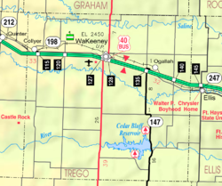
[edit]Riga is located at 39°06′12″N 99°14′44″W / 39.10333°N 99.24556°W at an elevation of 2,221 feet (677 m).[1] It is in far east-central Trego County roughly 4 miles (6.4 km) west of Ellis in neighboring Ellis County[3] It lies to the north of Big Creek in the western extent of the Smoky Hills region of the Great Plains.[3]
Transportation
[edit]Rail
[edit]- The Kansas Pacific (KP)[4][5] line of the Union Pacific Railroad runs southeast–northwest through Riga, with a siding for the grain elevator.
- Until 1946, Riga received scheduled local passenger service, at least twice daily; e.g., morning westbound train 69-369 and evening eastbound train 370-70.[6][7]
- However, there is recollection that, in the 1950s, the eastbound and westbound Portland Rose trains would meet at Riga.[8]
- In the 50s and 60s, the eastbound and westbound Portland Rose trains were scheduled to leave Oakley and Ellis, respectively, at about the same time in the early afternoon; and, would have to meet each other at a passing siding on the single track in between.[9][10]
- If the westbound was delayed in leaving Ellis, Riga was the last siding outside of Ellis where the eastbound could wait for the westbound to clear the station.
- When the Union Pacific rebuilt the Kansas Pacific line in the late 1990s, a new 9300 ft. siding was built just west of Riga.[8]
- Until 1946, Riga received scheduled local passenger service, at least twice daily; e.g., morning westbound train 69-369 and evening eastbound train 370-70.[6][7]
Highways
[edit]- Riga Road (FAS 1854)[4] runs north–south through the location, connecting to Exit 140 of Interstate 70 a mile to the north.[3]
- The first section of Interstate 70 to be built in western Kansas was completed by 1961 from Riga to Collyer.[11]
- 40 Hwy (FAS 1977),[4] parallel to and south of the railroad tracks, an old alignment of U.S. Route 40,[11] runs southeast–northwest through Riga and is a direct connection between the downtowns of WaKeeney (county seat) and Ellis.[12]
References
[edit]- ^ a b c d e f "Riga, Kansas", Geographic Names Information System, United States Geological Survey, United States Department of the Interior
- ^ "Trego County Profile". zipdatamaps. Retrieved December 30, 2020.
- ^ a b c "Riga, Glencoe, Kansas". Google Maps. Retrieved December 30, 2020.
- ^ a b c "General Highway Map - Trego County, Kansas" (PDF). Kansas Department of Transportation. 1978. Retrieved December 30, 2020.
- ^ "UPRR Common Line Names" (PDF). Union Pacific Railroad. Retrieved December 30, 2020.
- ^ Time Tables (PDF). Union Pacific Railroad. June 2, 1946. Retrieved January 9, 2021.
- ^ Condensed Time Tables (PDF). Union Pacific Railroad. September 1, 1947. Retrieved January 9, 2021.
Riga is not listed on any table
- ^ a b "Historic Venues on the Prairies of Kansas". Trainorders.com Nostalgia & History. December 30, 2020.
- ^ Time Tables (PDF). Union Pacific Railroad. September 26, 1954. Retrieved January 9, 2021.
- ^ Time Tables (PDF). Union Pacific Railroad. Summer 1958. Retrieved January 9, 2021.
- ^ a b "Official 1960–61 Kansas Highway Map" (PDF). Kansas Department of Transportation. Retrieved July 16, 2015.
- ^ Kansas 2005–2006 Official Transportation Map
Further reading
[edit]External links
[edit]


