Raciążek
Appearance
Raciążek | |
|---|---|
Village | |
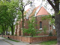
 Church of All Saints and St. Jerome, 16th century. | |
| Coordinates: 52°52′N 18°49′E / 52.867°N 18.817°E | |
| Country | |
| Voivodeship | Kuyavian-Pomeranian |
| County | Aleksandrów |
| Gmina | Raciążek |
| Elevation | 80 m (260 ft) |
| Population | |
• Total | 1,601 |
| Time zone | UTC+1 (CET) |
| • Summer (DST) | UTC+2 (CEST) |
| Vehicle registration | CAL |
Raciążek [raˈt͡ɕɔ̃ʐɛk] is a village in Aleksandrów County, Kuyavian-Pomeranian Voivodeship, in north-central Poland.[1] It is the seat of the gmina (administrative district) called Gmina Raciążek. It lies 8 kilometres (5 mi) east of Aleksandrów Kujawski and 23 km (14 mi) south-east of Toruń.
History
[edit]
According to the 1921 census, the town had a population of 1,146, entirely Polish by nationality, 97.6% Roman Catholic and 1.8% Lutheran by confession.[2]
Following the German-Soviet invasion of Poland, which started World War II in September 1939, Raciążek was occupied by Germany until 1945.
References
[edit]- ^ "Central Statistical Office (GUS) - TERYT (National Register of Territorial Land Apportionment Journal)" (in Polish). 2008-06-01.
- ^ Skorowidz miejscowości Rzeczypospolitej Polskiej (in Polish). Vol. I. Warszawa: Główny Urząd Statystyczny. 1925. p. 103.


