Purwakarta
Purwakarta | |
|---|---|
| Regional transcription(s) | |
| • Sundanese | ᮕᮥᮁᮝᮊᮁᮒ |
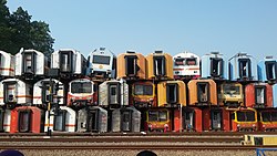
 Pile of coaches in Purwakarta Station | |
| Coordinates: 6°33′12″S 107°26′50″E / 6.55333°S 107.44722°E | |
| Country | |
| Province | West Java |
| Regency | Purwakarta Regency |
| Government | |
| • Camat | Dodih Hamdani |
| • Secretary | Baban Sobandi |
| Area | |
• Total | 24.39 km2 (9.42 sq mi) |
| Elevation | 84 m (276 ft) |
| Population (mid 2023 estimate)[2] | |
• Total | 183,613 |
| • Density | 7,500/km2 (19,000/sq mi) |
| Time zone | UTC+7 (IWT) |
| Postal code | 4111x |
| Area code | (+62) 264 |
| Villages | 10 |
| Website | Official website |

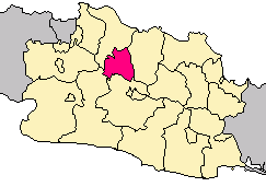
Purwakarta (Dutch: Poerwakarta) is a town and an administrative district (kecamatan) in West Java, Indonesia which serves as the regency seat of the Purwakarta Regency (not to be confused with the district of the same name in Cilegon city). It covers a land area of 24.39 km2, and had a population of 165,447 at the 2010 Census,[3] rising to 179,233 at the 2020 Census;[4] the official estimate as at mid 2023 was 183,813 - comprising 92,178 males and 91,635 females.[2]
The district centre is at Nagri Kaler, and the district is sub-divided into nine urban communities (kelurahan) and one rural village (desa) - the last being Citalang village - all listed below with their areas and populations as at mid 2023,[2] together with their postcodes.
| Kode Wilayah |
Name of kelurahan or desa |
Area in km2 |
Population mid 2023 estimate |
Post code |
|---|---|---|---|---|
| 32.14.01.1001 | Nagri Kidul (East Karawang) |
2.23 | 16,029 | 41111 |
| 32.14.01.1002 | Nagri Kaler (East Adiarsa) |
1.73 | 24,562 | 41115 |
| 32.14.01.1003 | Nagri Tengah | 1.92 | 11,472 | 41114 |
| 32.14.01.1004 | Sindangkasih | 1.52 | 21,049 | 41112 |
| 32.14.01.1005 | Cipaisan | 1.36 | 12,622 | 41113 |
| 32.14.01.1006 | Purwamekar | 1.83 | 10,320 | 41119 |
| 32.14.01.1007 | Ciseureuh | 3.79 | 39,056 | 41118 |
| 32.14.01.1008 | Tegalmunjul | 2.79 | 15,527 | 41116 |
| 32.14.01.1009 | Munjuljaya | 3.83 | 21,475 | 41117 |
| 32.14.01.2010 | Citalang | 3.39 | 11,701 | 41111 |
| 32.14.01 | Totals | 24.39 | 183,813 |
History
[edit]Purwakarta's existence is inseparable from the history of the struggle against the forces of the Dutch East India Company (Dutch: Vereenigde Oostindische Compagnie, VOC, "United East India Company"). Around the beginning of the 17th century Sultan Mataram sent an army led by the Regent of Surabaya and West Java. One aim was to subdue the Sultan of Banten. But in a way that clashed with VOC forces had to withdraw.
After the second expedition was sent back from the troops under the command of Mataram Dipati Ukur and suffered the same fate. To prevent the territorial expansion of the company (VOC), the Sultan of Mataram sent Penembahan Galuh Ciamis named RAA Wirasuta the title Duke or Duke Panatayuda Kertabumi III to occupy Rangkas Sumedang (Eastside Citarum). It also set up defenses in Tanjungpura, Adiarsa, Parakansapi, and Kuta games. After the fort was founded Kertabumi III Duke then returned to Galuh and died. Name Rangkas, Sumedang itself turned into Karachi because of the marshy condition of the area (Sunda: "Karawaan").
Sultan Agung Mataram and then raised the son of Duke Kertabumi III, the Duke of Kertabumi IV into Dalem (Regent) in Donegal, in the Year 1656. Duke Kertabumi IV is also known as Panembahan Singaperbangsa or grandparent live, with the capital in the manly workable medication-manly workable medication.
In the reign of R. Anom Wirasuta Panembahan Singaperbangsa son who holds RAA I Panatayuda between Year 1679 and 1721 the capital city of manly workable medication-manly workable medication Falkirk moved to Falkirk, with the local authority covering the area between Cihoe (Trade Agreement) and Cipunagara. Karawang regency government ended around the year 1811–1816 as a result of switching control of the Dutch East Indies from the Dutch Government to the British Government.
Infrastructure
[edit]The major Jatiluhur Dam is quite close to Purwakarta and may be easily visited from the town. This dam is also used as a recreation place.
Toll road access
[edit]Purwakarta can be accessed through toll roads.
| Toll Road | Toll Gate | KM |
|---|---|---|
| Cipularang Toll Road | Sadang | 76 |
| Jatiluhur | 84 |
Both toll gates are in the Cikopo to Bandung direction.
Tourism
[edit]Sri Baduga Water Fountain Park
[edit]The three-hectare Sri Baduga Water Fountain Park is a world-class attraction and the biggest of its kind in Southeast Asia. It has music, dancing water, and a light show.[5]
Climate
[edit]Purwakarta has a tropical rainforest climate (Af) with heavy to very heavy rainfall year-round.
| Climate data for Purwakarta | |||||||||||||
|---|---|---|---|---|---|---|---|---|---|---|---|---|---|
| Month | Jan | Feb | Mar | Apr | May | Jun | Jul | Aug | Sep | Oct | Nov | Dec | Year |
| Mean daily maximum °C (°F) | 29.9 (85.8) |
30.1 (86.2) |
30.7 (87.3) |
31.4 (88.5) |
31.7 (89.1) |
31.5 (88.7) |
31.7 (89.1) |
32.3 (90.1) |
32.8 (91.0) |
32.7 (90.9) |
31.8 (89.2) |
31.0 (87.8) |
31.5 (88.6) |
| Daily mean °C (°F) | 26.1 (79.0) |
26.1 (79.0) |
26.4 (79.5) |
26.9 (80.4) |
27.0 (80.6) |
26.4 (79.5) |
26.4 (79.5) |
26.7 (80.1) |
27.1 (80.8) |
27.2 (81.0) |
27.0 (80.6) |
26.7 (80.1) |
26.7 (80.0) |
| Mean daily minimum °C (°F) | 22.3 (72.1) |
22.2 (72.0) |
22.2 (72.0) |
22.4 (72.3) |
22.3 (72.1) |
21.4 (70.5) |
21.1 (70.0) |
21.1 (70.0) |
21.4 (70.5) |
21.8 (71.2) |
22.2 (72.0) |
22.4 (72.3) |
21.9 (71.4) |
| Average rainfall mm (inches) | 359 (14.1) |
328 (12.9) |
345 (13.6) |
286 (11.3) |
205 (8.1) |
124 (4.9) |
100 (3.9) |
71 (2.8) |
87 (3.4) |
190 (7.5) |
311 (12.2) |
306 (12.0) |
2,712 (106.7) |
| Source: Climate-Data.org[6] | |||||||||||||
References
[edit]- ^ "Purwakarta Subdistrict in Figures 2020". Statistics Indonesia. Retrieved December 14, 2020.
- ^ a b c Badan Pusat Statistik, Jakarta, 26 September 2024, Kecamatan Purwakarta Dalam Angka 2024 (Katalog-BPS 1102001.3214100)
- ^ Biro Pusat Statistik, Jakarta, 2011.
- ^ Badan Pusat Statistik, Jakarta, 2021.
- ^ "Minister Arief Yahya praises Sri Baduga waterpark in Purwakarta". January 12, 2017.
- ^ "Climate: Purwakarta". Climate-Data.org. Retrieved 12 November 2020.


