Portal:Myanmar
Portal maintenance status: (March 2022)
|

Myanmar, officially the Republic of the Union of Myanmar and also rendered as Burma (the official English form until 1989), is a country in northwest Southeast Asia. It is the largest country by area in Mainland Southeast Asia and has a population of about 55 million. It is bordered by India and Bangladesh to its northwest, China to its northeast, Laos and Thailand to its east and southeast, and the Andaman Sea and the Bay of Bengal to its south and southwest. The country's capital city is Naypyidaw, and its largest city is Yangon (formerly Rangoon).
Myanmar is a member of the East Asia Summit, Non-Aligned Movement, ASEAN, and BIMSTEC, but it is not a member of the Commonwealth of Nations despite once being part of the British Empire. Myanmar is a Dialogue Partner of the Shanghai Cooperation Organization. The country is very rich in natural resources, such as jade, gems, oil, natural gas, teak and other minerals, as well as also endowed with renewable energy, having the highest solar power potential compared to other countries of the Great Mekong Subregion. However, Myanmar has long suffered from instability, factional violence, corruption, poor infrastructure, as well as a long history of colonial exploitation with little regard to human development. In 2013, its GDP (nominal) stood at US$56.7 billion and its GDP (PPP) at US$221.5 billion. The income gap in Myanmar is among the widest in the world, as a large proportion of the economy is controlled by cronies of the military junta. Myanmar is one of the least developed countries; as of 2022, according to the Human Development Index, it ranks 144 out of 193 countries in terms of human development. Since 2021, more than 600,000 people were displaced across Myanmar due to the surge in violence post-coup, with more than three million people in dire need of humanitarian assistance. (Full article...)
Selected articles - load new batch
-
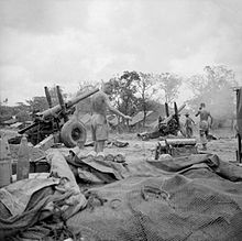
Image 15.5-inch guns of the Royal Artillery firing on Japanese troops attempting to break out of the Sittang Bend in early August 1945
The Battle of the Sittang Bend and the Japanese Breakout across Pegu Yomas were linked Japanese military operations during the Burma Campaign, which took place nearly at the end of World War II. Surviving elements of the Imperial Japanese Army who had been driven into the Pegu Yoma attempted to break out eastwards in order to join other Japanese troops retreating from the British forces. The break-out was the objective of the Japanese Twenty-Eighth Army with support at first from the Thirty-Third Army and later the Fifteenth Army. As a preliminary, the Japanese Thirty-Third Army attacked Allied positions in the Sittang Bend, near the mouth of the river, to distract the Allies. The British had been alerted to the break-out attempt and it ended calamitously for the Japanese, who suffered many losses, with some formations being wiped out.
There were around 14,000 Japanese casualties, with well over half being killed, while British forces suffered only 95 killed and 322 wounded. The break-out attempt and the ensuing battle became the last significant land battle of the Western powers in the Second World War. (Full article...) -
Image 2Confluence of Ruak River and Mekong Rivers, view from Wat Phra That Doi Pu Khao [th] in Ban Sop Ruak
The Golden Triangle is a large, mountainous region of approximately 200,000 km2 (77,000 sq mi) in northeastern Myanmar, northwestern Thailand and northern Laos, centered on the confluence of the Ruak and Mekong rivers. The name "Golden Triangle" was coined by Marshall Green, a U.S. State Department official, in 1971 in a press conference on the opium trade. Today, the Thai side of the river confluence, Sop Ruak, has become a tourist attraction, with the House of Opium Museum, a Hall of Opium, and a Golden Triangle Park, and no opium cultivation.
The Golden Triangle has been one of the largest opium-producing areas of the world since the 1950s. Most of the world's heroin came from the Golden Triangle until the early 21st century when opium production in Afghanistan increased. Myanmar was the world's second-largest source of opium after Afghanistan up to 2022, producing some 25% of the world's opium, forming part of the Golden Triangle. While opium poppy cultivation in Myanmar had declined year-on-year since 2015, cultivation area increased by 33% totalling 40,100 ha (99,000 acres) alongside an 88% increase in yield potential to 790 t (780 long tons; 870 short tons) in 2022 according to latest data from the United Nations Office on Drugs and Crime (UNODC) Myanmar Opium Survey 2022. The United Nations Office on Drugs and Crime has also warned that opium production in Myanmar may rise again if the economic crunch brought on by COVID-19 and the country's 2021 Myanmar coup d'état persists, with significant public health and security consequences for much of Asia. (Full article...) -
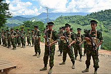
Image 3Cadets of the Kachin Independence Army (KIA) preparing for military drills at the group's headquarters in Laiza, Kachin State.
The Kachin conflict or the Kachin War is one of the multiple conflicts which are collectively referred to as the internal conflict in Myanmar. Kachin insurgents have been fighting against the Tatmadaw (Myanmar Armed Forces) since 1961, with only one major ceasefire being brokered between them, which lasted from 1994 to 2011, a total of 17 years.
Since the resumption of hostilities in 2011, thousands of civilians have been killed, whilst over 100,000 more have been displaced. Widespread use of landmines, child soldiers, systematic rape and torture have been alleged by both sides. (Full article...) -
Image 4Myanmar (Burma) is a Buddhist majority country with a significant minority of Christians and other groups residing in the country.
Buddhism is a part of Myanmar culture. Section 361 of the Constitution states that "The Union recognizes the special position of Buddhism as the faith professed by the great majority of the citizens of the Union."
According to both the 2014 census of the Burmese government Buddhism is the dominant religion, of 89.8% of the population, practiced especially by the Bamar, Rakhine, Shan, Mon and Chinese ethnic groups. Bamar people also practice the Burmese folk religion under the name of Buddhism. The 2008 constitution provides for the freedom of religion; however, it also grants broad exceptions that allow the regime to restrict these rights at will. (Full article...) -
Image 5Hkakaborazi National Park is a national park in northern Myanmar with an area of 1,472 sq mi (3,810 km2). It was established in 1998.
It surrounds Hkakabo Razi, the highest mountain in the country.
It ranges in elevation from 2,950 to 18,730 ft (900 to 5,710 m) comprising evergreen forest and mixed deciduous forests in Nogmung Township, Kachin State. It is managed by the Nature and Wildlife Conservation Division.
It is contiguous with Bumhpa Bum Wildlife Sanctuary and Hukaung Valley Wildlife Sanctuary. These protected areas together with Hponkanrazi Wildlife Sanctuary comprise the largest continuous expanse of natural forest called the Northern Forest Complex stretching over an area of 11,624 sq mi (30,110 km2). Its objective is to conserve the biodiversity of the Ayeyarwady and Chindwin river basins. (Full article...) -
Image 6
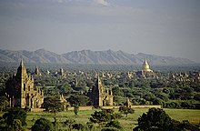
Bagan (Burmese: ပုဂံ; MLCTS: pu.gam, IPA: [bəɡàɰ̃]; formerly Pagan) is an ancient city and a UNESCO World Heritage Site in the Mandalay Region of Myanmar. From the 9th to 13th centuries, the city was the capital of the Pagan Kingdom, the first kingdom that unified the regions that would later constitute Myanmar. During the kingdom's height between the 11th and 13th centuries, more than 10,000 Buddhist temples, pagodas and monasteries were constructed in the Bagan plains alone, of which the remains of over 2200 temples and pagodas survive.
The Bagan Archaeological Zone is a main attraction for the country's nascent tourism industry. (Full article...) -
Image 7
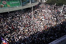
Protests in Myanmar, known locally as the Spring Revolution (Burmese: နွေဦးတော်လှန်ရေး, Burmese pronunciation: [nwè.ú.tɔ̀.l̥àɰ̃.jé]), began in early 2021 in opposition to the coup d'état on 1 February, staged by Min Aung Hlaing, the commander-in-chief of the country's armed forces, the Tatmadaw. As of 23 June 2022[update], at least 2000 protesters have been killed, 14,000 arrested and 700,000 displaced by the military junta.
Protesters mostly employed peaceful and nonviolent forms of protest, which included acts of civil disobedience, labour strikes, a military boycott campaign, a pot-banging movement, a red ribbon campaign, public protests, and formal recognition of the election results by elected representatives. The colour red, which is associated with the National League for Democracy (NLD), has been donned by many protesters. "Kamba Ma Kyay Buu", a song that was first popularised as the anthem of the 8888 Uprising (1988), has been revitalised by the civil disobedience movement as a protest song. The three-finger salute has been widely adopted by protesters as a protest symbol. (Full article...) -
Image 8
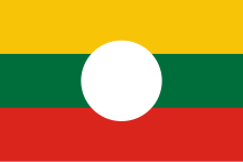
Shan State (Shan: မိူင်းတႆး, Möng Tai; Burmese: ရှမ်းပြည်နယ်, pronounced [ʃáɰ̃ pjìnɛ̀]) is a state of Myanmar. Shan State borders China (Yunnan) to the north, Laos (Louang Namtha and Bokeo Provinces) to the east, and Thailand (Chiang Rai, Chiang Mai and Mae Hong Son Provinces) to the south, and five administrative divisions of Myanmar in the west. The largest of the 14 administrative divisions by land area, Shan State covers 155,800 km2, almost a quarter of the total area of Myanmar. The state gets its name from the Burmese name for the Tai peoples: "Shan people". The Tai (Shan) constitute the majority among several ethnic groups that inhabit the area. Shanland is largely rural, with only three cities of significant size: Lashio, Kengtung, and the capital, Taunggyi. Taunggyi is 150.7 km northeast of the nation's capital Naypyitaw.
The Shan state, with many ethnic groups, is home to several armed ethnic groups. While the military government has signed ceasefire agreements with most groups, vast areas of the state, especially those east of the Salween River, remain outside the central government's control, and in recent years have come under heavy ethnic-Han Chinese economic and political influence. Other areas are under the control of military groups such as the Shan State Army. (Full article...) -
Image 9

The Burma Independence Army (BIA) was a pro-Japanese and revolutionary army that fought for the end of British rule in Burma by assisting the Japanese in their conquest of the country in 1942 during World War II. It was the first post-colonial army in Burmese history. The BIA was formed from a group known as the Thirty Comrades under the auspices of the Imperial Japanese Army after training the Burmese nationalists in 1941. The BIA's attempts at establishing a government during the invasion led to it being dissolved by the Japanese and the smaller Burma Defence Army (BDA) formed in its place. As Japan guided Burma towards nominal independence, the BDA was expanded into the Burma National Army (BNA) of the State of Burma, a puppet state under Ba Maw, in 1943.
After secret contact with the British during 1944, on 27 March 1945, the BNA revolted against the Japanese. The army received recognition as an ally from Supreme Allied Commander, Lord Mountbatten, who needed their assistance against retreating Japanese forces and to ease the strain between the army's leadership and the British. As part of the Anti-Fascist People's Freedom League, the BNA was re-labelled the Patriotic Burmese Forces (PBF) during a joint Allied–Burmese victory parade in Rangoon on 23 June 1945. Following the war, after tense negotiations, it was decided that the PBF would be integrated into a new Burma Army under British control, but many veterans would continue under old leadership in the paramilitary People's Volunteer Organisation (PVO) in the unstable situation of post-war Burma. (Full article...) -
Image 10The Thirty Comrades (Burmese: ရဲဘော်သုံးကျိပ်) constituted the embryo of the modern Burmese army called the Burma Independence Army (BIA) which was formed to fight for independence from Britain. This was accomplished just before the majority of the Thirty Comrades returned with the invading Japanese Army initially through Southern Burma in December 1941.
In April 1941, small groups of Burmese youth left Burma secretly to obtain military training to fight the British colonists in the struggle for independence. Their leader was Thakin Aung San and they were sent by the Dobama Asiayone ("We Burmans Association") with the intention to get assistance from Guangzhou. By a quirk of fate, however, they ran into the Japanese instead in Amoy and arrived in Japan later to be flown to occupied parts of Sanya, in order to receive military training from the Japanese Army. They were later moved to Formosa for security reasons and subsequently returned to Burma via Vietnam and
Thailand with the Japanese. On 26 December 1941, in a house (owned by a Burmese doctor) in Bangkok, about 25 of the Thirty Comrades had their blood drawn from their arms in syringes, then poured into a silver bowl from which each of them drank – thway thauk in time-honoured Burmese military tradition – pledging "eternal loyalty" among themselves and to the cause of Burmese independence. Their average age was just 24 years. A Japanese officer called Suzuki Keiji, better known among the Burmese by his nom de guerre Bo Mogyo (Commander Thunderbolt) and head of a special intelligence unit called Minami Kikan (南機関) formed in order to support a national uprising in Burma, was the mentor and principal trainer of the Thirty Comrades. The British were driven out of Burma to India during World War II. (Full article...)
Did you know (auto-generated) - load new batch

- ... that while defending Zaw Myint Maung following his arrest by the Myanmar junta, lawyer Ywet Nu Aung was herself arrested and charged?
- ... that Molly Burman resumed releasing music three years later after finding that "Happy Things" had accrued a million streams on Spotify?
- ... that Rolling Stone named Mission of Burma's "Academy Fight Song" as one of the 100 greatest debut singles of all time?
- ... that the mission of the United Nations special envoy on Myanmar has been called a "diplomatic graveyard"?
- ... that Thinzar Shunlei Yi hid in the Burmese jungle for a month and joined a rebel militia following the 2021 Myanmar coup d'état?
- ... that squatters in Myanmar were punished for protesting against the 2021 coup d'état by being evicted?
- ... that one academic described the introduction of femboys to Myanmar as a tactic to achieve an "ideological revolution"?
- ... that Rangoon kept its own time for more than two decades after Burma Standard Time first came into effect?
Related portals and projects
General images - load new batch
-
Image 1Two female musicians play the saung at a performance in Mandalay. (from Culture of Myanmar)
-
Image 2Temples at Mrauk U, the capital of the Mrauk U Kingdom, which ruled over what is now Rakhine State (from History of Myanmar)
-
Image 3The paddle steamer Ramapoora (right) of the British India Steam Navigation Company on the Rangoon river having just arrived from Moulmein. 1895. Photographers: Watts and Skeen. (from History of Myanmar)
-
Image 4Recorder's Court on Sule Pagoda Road, with the Sule Pagoda at the far end, Rangoon, 1868. Photographer: J. Jackson. (from History of Myanmar)
-
Image 5Pagan Kingdom during Narapatisithu's reign. Burmese chronicles also claim Kengtung and Chiang Mai. Core areas shown in darker yellow. Peripheral areas in light yellow. Pagan incorporated key ports of Lower Burma into its core administration by the 13th century. (from History of Myanmar)
-
Image 6A group of Buddhist worshipers at Shwedagon Pagoda, an important religious site for Burmese Buddhists (from Culture of Myanmar)
-
Image 7Sculpture of Myanmar mythical lion (from Culture of Myanmar)
-
Image 9Myinhkin thabin - equestrian sport (from Culture of Myanmar)
-
Image 10Salween river at Mae Sam Laep on the Thai-Myanmar border (from Geography of Myanmar)
-
Image 11A theatrical performance of the Mon dance (from Culture of Myanmar)
-
Image 12Aerial view of a burned Rohingya village in Rakhine state, September 2017 (from History of Myanmar)
-
Image 14The restored Taungoo or Nyaungyan dynasty, c. 1650 CE (from History of Myanmar)
-
Image 15Aung San Suu Kyi addresses crowds at the NLD headquarters shortly after her release. (from History of Myanmar)
-
Image 16British soldiers on patrol in the ruins of the Burmese town of Bahe during the advance on Mandalay, January 1945 (from History of Myanmar)
-
Image 17Myanmar (Burma) map of Köppen climate classification (from Geography of Myanmar)
-
Image 19British soldiers remove their shoes at the entrance of Shwedagon Pagoda. To the left, a sign reads "Foot wearing is strictly prohibited" in Burmese, English, Tamil, and Urdu. (from Culture of Myanmar)
-
Image 20Boxing match, 19th-century watercolour (from Culture of Myanmar)
-
Image 21Grandfather Island, Dawei (from Geography of Myanmar)
-
Image 24Military situation in Myanmar as of 2024[update]. Areas controlled by the Tatmadaw are highlighted in red. (from History of Myanmar)
-
Image 25Protesters in Yangon with a banner that reads "non-violence: national movement" in Burmese. In the background is Shwedagon Pagoda. (from History of Myanmar)
-
Image 26A bull fight, 19th-century watercolour (from Culture of Myanmar)
-
Image 28Saint Mary's Cathedral in Downtown Yangon is the largest Roman Catholic cathedral in Burma. (from Culture of Myanmar)
-
Image 29Political map of Burma (Myanmar) c. 1450 CE. (from History of Myanmar)
-
Image 30A large fracture on the Mingun Pahtodawgyi caused by the 1839 Ava earthquake. (from Geography of Myanmar)
-
Image 32Former US President Barack Obama poses barefoot on the grounds of Shwedagon Pagoda, one of Myanmar's major Buddhist pilgrimage sites. (from Culture of Myanmar)
-
Image 34Vegetable stall on the roadside at the Madras Lancer Lines, Mandalay, January 1886. Photographer: Hooper, Willoughby Wallace (1837–1912). (from History of Myanmar)
-
Image 35Portuguese ruler and soldiers mounting an elephant. Jan Caspar Philips (draughtsman and engraver). (from History of Myanmar)
-
Image 36A wedding procession, with the groom and bride dressed in traditional Burmese wedding clothes, reminiscent of royal attire (from Culture of Myanmar)
-
Image 3719th-century funeral cart and spire, which would form part of the procession from the home to the place of cremation (from Culture of Myanmar)
-
Image 38Protesters in Yangon carrying signs reading "Free Daw Aung San Suu Kyi" on 8 February 2021 (from History of Myanmar)
-
Image 39The shores of Irrawaddy River at Nyaung-U, Bagan (from Geography of Myanmar)
-
Image 40British soldiers dismantling cannons belonging to King Thibaw's forces, Third Anglo-Burmese War, Ava, 27 November 1885. Photographer: Hooper, Willoughby Wallace (1837–1912). (from History of Myanmar)
-
Image 41Hlei pyaingbwè - a Burmese regatta (from Culture of Myanmar)
Major topics
Categories
More topics
|
| |||||||||||||||||||||||||||||||||||||||||||||||||||||||||||||||||||||||||||||||||||||||||||||||||||||||||||||||||||||||||||||||||||||||||||||||||||||||||||||||||||||||||||||||||||||||||||||||||||||||||||
Associated Wikimedia
The following Wikimedia Foundation sister projects provide more on this subject:
-
Commons
Free media repository -
Wikibooks
Free textbooks and manuals -
Wikidata
Free knowledge base -
Wikinews
Free-content news -
Wikiquote
Collection of quotations -
Wikisource
Free-content library -
Wikiversity
Free learning tools -
Wikivoyage
Free travel guide -
Wiktionary
Dictionary and thesaurus





![Image 24Military situation in Myanmar as of 2024[update]. Areas controlled by the Tatmadaw are highlighted in red. (from History of Myanmar)](http://up.wiki.x.io/wikipedia/commons/thumb/c/c1/Myanmar_civil_war.svg/73px-Myanmar_civil_war.svg.png)


