Portal:Geology/Selected picture
Appearance
The Selected picture box on the portal chooses one of the following at random when displaying the page. Follow the instructions below for adding or nominating a new picture to the list.
Picture candidates
[edit]Feel free to add related featured pictures to the list. Nominate other pictures on the portal talk page.
- Pictures must be
- Free to use and hosted on Commons
- Of good quality (not blurred, grainy or discoloured)
- Interesting
- Relevant to an article or topic
To find appropriate pictures, use search box below:
Instructions
[edit]- For pictures, which appeared as picture of the day on the Main Page, just add the date in
YYYY-MM-DDformat to the list (please keep the list sorted). - For other pictures, use following parameters:
|iN=
|titleN=
|creditN=
|captionN=
where N is the next unused number.
Selected pictures list
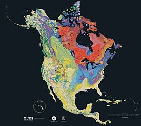
[edit]Cartographic relief depiction showing the varying age of bedrock underlying North America. This image combines a geologic map and a shaded relief image. This combination reveals the geologic history of North America through the interrelation of rock type, topography and time. Regional surface processes as well as continent-scale tectonic events are exposed in the three dimensions of space and the fourth dimension, geologic time. From most recent to oldest, age is indicated by color: yellow, green, blue, red.
Image credit: Galileo spacecraft
This false-color mosaic showing compositional variations in the geology of the Moon was constructed from a series of 53 images taken through three spectral filters by the imaging system of the Galileo spacecraft. Bright pinkish areas are highlands materials, such as those surrounding the oval lava-filled Mare Crisium impact basin toward the bottom. Blue to orange shades indicate volcanic lava flows. To the left of Crisium, the dark blue Mare Tranquillitatis is richer in titanium than the green and orange maria above it. Thin mineral-rich soils associated with relatively recent impacts are represented by light blue colors. The monochrome band on the right edge shows the unretouched surface of the moon.
Map: Grandiose, based on a map by the United States Geological Survey
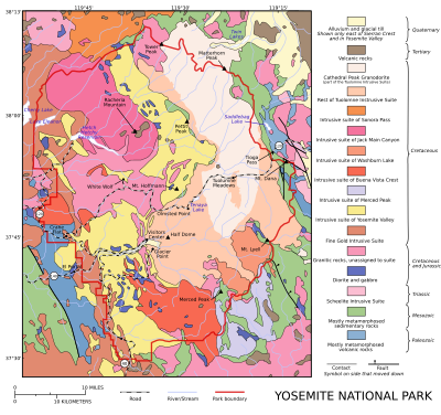
A geological map of Yosemite National Park (full size), showing the Cathedral Peak Granodiorite, the largest unit in the Tuolumne Intrusive Suite, which in turn is the largest granitic suite in the park.
Cathedral Peak Granodiorite
Rest of the Tuolumne Intrusive SuiteMap: Strebe, using Geocart
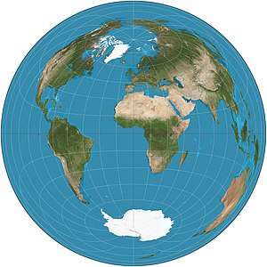
The Lambert azimuthal equal-area projection is a projection used for mapping a sphere to a disk. It accurately represents area in all regions of the sphere, but it does not accurately represent angles. It is used in scientific disciplines such as geology for plotting the orientations of lines in three-dimensional space, and by the National Atlas of the US in its online map-making application.
Curiosity is a car-sized rover designed to explore the crater Gale on Mars as part of NASA's Mars Science Laboratory mission. It was launched from Cape Canaveral in November 2011 and landed on Aeolis Palus inside Gale on August 6, 2012, at 05:17 UTC. Curiosity's landing site, nicknamed Bradbury Landing, was less than 2.4 km (1.5 mi) from the center of the rover's touchdown target after a 560-million km (350-million mi) journey. The rover's goals include an investigation of the Martian climate and geology; assessment of whether the selected field site inside Gale has ever offered environmental conditions favorable for microbial life, including investigation of the role of water; as well as planetary habitability studies in preparation for human exploration.
This picture is a self-portrait of Curiosity on Mars at the "Big Sky" drilling site, where it collected a rock sample at the foothills of Aeolis Mons (Mount Sharp) in October 2015. The photograph combines dozens of images taken by the Mars Hand Lens Imager (MAHLI) camera at the end of the rover's robotic arm; the arm itself is not included, although its shadow is visible on the ground. Wrist motions and turret rotations on the arm allowed MAHLI to acquire the mosaic's component images.


