Portal:Geography/Featured picture archive/2010
Archive of pictures
[edit]2010
 |
|
Topographical map of Burma. Photo credit: Captain Blood |
 |
|
Topographical map of Burundi. Photo credit: Sadalmelik |
 |
|
Map of the Tonle Sap Lake and its floodplain in Cambodia. Photo credit: Matti Kummu |
 |
|
Volcanic plugs dot the landscape near Rhumsiki, Far North Region in Cameroon. Photo credit: Amcaja |
 |
|
Geological map of Canada. The Canadian Shield, stretching North from the Great Lakes to the Arctic Ocean and covering over half of Canada, is a broad region of Precambrian rock (pictured in shades of red) that encircles Hudson Bay. Photo credit: USGS |
 |
|
Topographic map of Cape Verde. Photo credit: Mysid |
 |
|
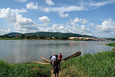
Ubangi River, a major tributary of the Congo River, at the outskirts of Bangui, capital of Central African Republic. Photo credit: Pete Chirico, USGS |
 |
|
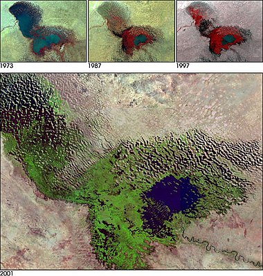
A composite of images showing the diminishing Lake Chad from 1973 to 2001. Photo credit: NASA |
 |
|
Satellite image of the Atacama Desert, located in northern Chile it covers a 600-mile (1,000 km) strip of land on the Pacific coast of South America, west of the Andes mountains. The Atacama desert is the driest desert in the world. Photo credit: NASA |
 |
|
Longsheng Rice Terrace in Longsheng county, Guilin, China. Photo credit: Anna Frodesiak |
 |
|
Topographic map of Colombia. Photo credit: Sadalmelik |
 |
|
Street in the Grande Comore Island, Comoros. Photo credit: Souef el marwane |
 |
|
Satellite picture of Brazzaville, Kinshasa and the Malebo Pool of the Congo River. The Democratic Republic of the Congo and the Republic of the Congo, both countries lying along the river's banks, are named after it. Photo credit: NASA |
 |
|
Arenal Volcano erupting in November 2006. Arenal is an active andesitic stratovolcano in north-western Costa Rica around 90 km northwest of San José. Photo credit: Matthew Landry |
 |
|
Topographic map of Côte d'Ivoire. In the center of the country on the Bandama River lies Lake Kossou, an artificial lake, created in 1973. Photo credit: Sadalmelik |
 |
|
Photo credit: Captain Blood |
 |
|
La Boca fisherman's village near Trinidad, Cuba with Escambray Mountains at the back. Photo credit: Wilder Mendez |
 |
|
Troodos Mountains with its highest peak Mount Olympus (1,952 metres) in Cyprus. Photo credit: Paul167 |
 |
|
Šance Dam in the Moravian-Silesian Beskids mountain range, Moravian-Silesian Region, Czech Republic. Photo credit: Martin Kovář |
 |
|
Karlebo, Sjælland, Denmark. 60% of the land in Denmark is arable. Photo credit: J. M. Rice |
 |
|
Topographic map of Djibouti. There is no arable land, irrigation, permanent crops, and negligible forest cover. Photo credit: Sadalmelik |
 |
|
Pano-wide image of Roseau, the capital of Dominica. Photo credit: Ted Rufus Ross |
 |
|
Beach on Saona Island, located a short distance from the mainland on the south-east tip of the Dominican Republic, near La Altagracia Province. Photo credit: Tamas Iklodi |
 |
|
Map of East Timor indicating cities and principal roads. Photo credit: Mats Halldin & CIA |
 |
|
Photo credit: Sadalmelik |
 |
|
The Nile River and delta. The delta formed in Northern Egypt where the Nile River spreads out and drains into the Mediterranean Sea. Photo credit: NASA |
 |
|
Two earthquakes hit El Salvador within exactly one month of each other, on January 13 and February 13, 2001. A landslide caused by the El Salvador quake. Photo credit: United States Geological Survey |
 |
|
Map of Equatorial Guinea. The island of Annobón is not shown. Photo credit: Demis.nl, Tonym88 |
 |
|
Photo credit: Sadalmelik |
 |
|
The largest of nine craters at Kaali, found on the island of Saaremaa, Estonia. Photo credit: Siim Ainsaar |
 |
|
Dendi Caldera, Ethiopia is featured in this image photographed by an Expedition 16 crew member on the International Space Station. The Dendi Caldera is located on the Ethiopian Plateau, approximately 86 kilometers to the southwest of Addis Ababa. A caldera is a geological feature formed by the near-total eruption of magma from beneath a volcano, leading to collapse of the volcanic structure into the now-empty magma chamber. Photo credit: NASA |
 |
|
Topography of Viti Levu island, Fiji. Fiji's largest island, Viti Levu, is home to 70% of the population (about 600,000). Photo credit: NASA |
 |
|
Repovesi National Park in southeastern Finland. Photo credit: M. Passinen |
Portal:Geography/Featured picture/2010, week 34
Portal:Geography/Featured picture/2010, week 35
 |
|
Map of Metropolitan French cities (agglomerations > 100,000 inhabitants on 1999 census). Photo credit: David.Monniaux |
 |
|
Topographic map of Gabon. Photo credit: Mysid |
Portal:Geography/Featured picture/2010, week 38
Portal:Geography/Featured picture/2010, week 39
Portal:Geography/Featured picture/2010, week 40
Portal:Geography/Featured picture/2010, week 41
Portal:Geography/Featured picture/2010, week 42
Portal:Geography/Featured picture/2010, week 43
Portal:Geography/Featured picture/2010, week 44
Portal:Geography/Featured picture/2010, week 45
Portal:Geography/Featured picture/2010, week 46
Portal:Geography/Featured picture/2010, week 47
 |
|
Peyto Lake in Banff National Park. Photo credit: Tobias Alt |
 |
|
Alter Strom, a canal in Warnemünde, Germany Photo credit: Alabama |
 |
|
Skyline of downtown Houston. Photo credit: Jujutacular |
 |
|
Danau Sentarum National Park in Borneo. Photo credit: Natureandpoverty.net |
 |
|
Tessellated pavement at Eaglehawk Neck, Tasmania . Photo credit: Noodle snacks |
