Pesanggrahan
Appearance
Pesanggrahan | |
|---|---|
 Location in South Jakarta | |
| Country | Indonesia |
| Province | Jakarta |
| Administrative city | South Jakarta |
Pesanggrahan is a district (Indonesian: kecamatan) in the administrative city of South Jakarta, Indonesia. The name Pesanggrahan is derived from Pesanggrahan River, which flows along the eastern edge of the district.[1] Pesanggrahan was originally part of the district Kebayoran Lama,[2] but was later split into a separate district. Pesanggrahan is bordered by the cities of Tangerang and South Tangerang to the west, West Jakarta to the north, and the district of Kebayoran Lama to the east.
A southwestern portion of the Jakarta Outer Ring Road and the Jakarta–Serpong railway passed through Pesanggrahan district.
Subdistricts
[edit]The district of Pesanggrahan is divided into five subdistricts (kelurahan):
| Name | Area code |
|---|---|
| Ulujami | 12250 |
| Petukangan Utara | 12260 |
| Petukangan Selatan | 12270 |
| Pesanggrahan | 12320 |
| Bintaro | 12330 |
Landmarks
[edit]
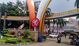
- Budi Luhur University
- Darunnajah Islamic Boarding School
- Metro Mall Cipulir
- Swadharma Park
- Bintaro Jaya[a]
Transportation
[edit]City Bus Transjakarta
[edit]- Transjakarta
 CBD Ciledug - Tegal Mampang
 - Transjakarta 1C Pesanggrahan - Blok M
- Transjakarta 1Q Rempoa - Blok M
- Transjakarta 8E Bintaro - Blok M
Mayasari Bhakti
[edit]- Mayasari Bhakti AC73 Kp Rambutan - Ciledug
MRT Jakarta Planned
[edit]- MRT Jakarta (Future Planned)
 PIK - Kampung Rambutan - Tanjung Priok Along the JORR Toll Road [3]
Access Toll Road
[edit]- Jakarta Outer Ring Road W2 North
- Jakarta-Serpong Toll Road Ulujami - Rawa Buntu
- Jakarta Outer Ring Road Ulujami - Pondok Pinang
Notes
[edit]- ^ Shared with parts in South Tangerang, Banten
References
[edit]- ^ "Asal Usul Nama Tempat Di Jakarta". Archived from the original on 2009-02-23.
- ^ "PESANGGRAHAN, VILLAGE".
- ^ JUTPI, "X-Jakarta Urban Railway Map (2024)", Transport for Jakarta, November 2024. Akses PDF

