Paya Terubong
Paya Terubong | |
|---|---|
Suburb of George Town | |
| Other transcription(s) | |
| • Mandarin | 垄尾 (Simplified) 壟尾 (Traditional) Lǒng wěi (Pinyin) |
| • Hokkien | Lóng-bué (Tâi-lô) |
| • Tamil | பாயா தெருபோங் Pāyā terupōṅ (Transliteration) |
 | |
 | |
| Coordinates: 5°22′22″N 100°16′47″E / 5.37278°N 100.27972°E | |
| Country | |
| State | |
| City | |
| Government | |
| • Local government | Penang Island City Council |
| • Mayor of Penang Island | Rajendran P. Anthony |
| • Paya Terubong State Assemblyman | Wong Hon Wai (DAP) |
| • Bukit Gelugor Member of Parliament | Ramkarpal Singh (DAP) |
| Area | |
• Total | 32.7 km2 (12.6 sq mi) |
| Population (2020)[1] | |
• Total | 226,712 |
| • Density | 6,900/km2 (18,000/sq mi) |
| Demographics | |
| • Ethnic groups | |
| Time zone | UTC+8 (MST) |
| • Summer (DST) | Not observed |
| Postal code | 11060 |
| Website | www |
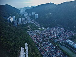
Paya Terubong is a suburb of George Town in the Malaysian state of Penang. Located nearly 7 km (4.3 mi) southwest of the city centre, it is nestled within the central valleys of Penang Island and south of Air Itam. Originally an agricultural village, rapid development in the last decades of the 20th century has transformed the area into a residential suburb.
Etymology
[edit]Paya Terubong was named after a species of grass known in Malay as terubong. Its scientific name is Cyrtococcum oxyphyllum.[2]
History
[edit]
Similar to Ayer Itam to the north, Paya Terubong was where agricultural farms were established, providing fresh produce to be traded in markets elsewhere in George Town. In the past, Paya Terubong Road was merely a hill path.
The area was developed in the 1980s with the construction of residential high-rises to alleviate land scarcity in the city. New townships such as Farlim were created, leading to an increase in population.
Geography
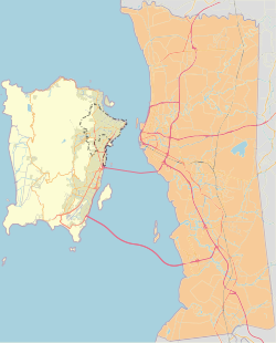
[edit]The subdivision of Paya Terubong covers an area of 32.7 km2 (12.6 sq mi), forming a corridor that stretches from the central valleys of Penang Island to Jerejak Island off the eastern coast. It encompasses a varied topography and includes several neighbourhoods, namely Farlim, Bukit Jambul, Sungai Dua, Batu Uban and parts of Sungai Nibong.[3]

2.5miles
Complex
Place
Heights
Melayu
Click link at the top right corner to zoom in.
Demographics
[edit]As of 2020[update], Paya Terubong was home to a population of 226,712, making it the most populated subdivision within the city of George Town.[1] The suburb had a population density of 6,933/km2 (17,960/sq mi). Ethnic Chinese constituted over 56% of Paya Terubong's population, while Malays formed another 23%. Non-citizens comprised almost 10% of the population, followed by Indians at over 9%.
Transportation
[edit]
Paya Terubong Road remains the main thoroughfare within the suburb. The road connects with Ayer Itam Road to the north and stretches towards the suburb of Relau near the southern end of the central valleys. As Paya Terubong Road is the sole road which links the north and south of Penang Island through the central valleys, heavy traffic congestion occurs on a frequent basis.[2][4] In 2022, part of the Jalan Bukit Kukus Paired Road was opened for use, intended to alleviate congestion between Paya Terubong and other suburbs to the south.
Rapid Penang buses 13, 201, 202, 306 and 502 serve the residents of the suburb, by connecting Paya Terubong with the city centre and various other destinations, such as Ayer Itam, the Penang International Airport, Queensbay Mall and Balik Pulau.[5][6][7][8][9]
Education
[edit]A total of 10 primary schools, five high schools and an international school are located throughout Paya Terubong.
Primary schools
|
|
High schools
- SMK Air Itam[20]
- SMK Bukit Gambir[21]
- SMK Bukit Jambul[22]
- Phor Tay High School
- SMK Sungai Nibong[23]
International school
Retail
[edit]Paya Terubong is served by neighbourhood retail centres, such as Bukit Jambul Complex, All Seasons Place and Sunshine Central. The six-storey Bukit Jambul Complex at Bukit Jambul was opened in 1997, while All Seasons Place at Farlim was touted as the first strip mall in Penang upon its launch in 2012.[25][26][27] In 2024, Suiwah Corporation, a local retail firm, launched Sunshine Central, a 3.64 ha (9.0-acre) mixed-use development that includes a nine-storey shopping mall.[28]
References
[edit]- ^ a b c d "MyCensus 2020: Mukim/Town/Pekan". Department of Statistics Malaysia. Putrajaya: 174–175. February 2024. ISBN 9789672537069.
- ^ a b "Rising with the times But there's much traffic congestion, lament residents – Community | The Star Online". www.thestar.com.my. Retrieved 2017-05-20.
- ^ "ArcGIS Web Application". pegis.penang.gov.my. Retrieved 2024-03-06.
- ^ "'Lebuh raya' Paya Terubong dijangka siap 2019 – ADUN | Buletin Mutiara". www.buletinmutiara.com. Retrieved 2017-05-20.
- ^ "Route 13". Archived from the original on 2016-07-22. Retrieved 2017-05-20.
- ^ "Route 201". Archived from the original on 2016-07-02. Retrieved 2017-05-20.
- ^ "Route 202". Archived from the original on 2016-07-02. Retrieved 2017-05-20.
- ^ "Route 306". Archived from the original on 2016-07-02. Retrieved 2017-05-20.
- ^ "Route 502". Archived from the original on 2016-07-02. Retrieved 2017-05-20.
- ^ "SK Bukit Gambir, Gelugor - Malaysia Education Directory". www.apac.com.my. Retrieved 2024-11-22.
- ^ "SJK (C) Chiao Nan, Ayer Itam - Malaysia Education Directory". www.apac.com.my. Retrieved 2024-11-22.
- ^ "SK SG GELUGOR - PULAU PINANG - Carian Sekolah Malaysia". www.sekolahmy.com (in Malay). Retrieved 2017-05-19.
- ^ "SJK (C) Keong Hoe, Gelugor - Malaysia Education Directory". www.apac.com.my. Retrieved 2024-11-22.
- ^ "SJK (C) Kong Min Cawangan Kedua, Ayer Itam - Malaysia Education Directory". www.apac.com.my. Retrieved 2024-11-22.
- ^ "SJK (C) Kwang Hwa, Bayan Lepas - Malaysia Education Directory". www.apac.com.my. Retrieved 2024-11-22.
- ^ "SJK (C) Min Sin, Bayan Lepas - Malaysia Education Directory". www.apac.com.my. Retrieved 2024-11-22.
- ^ "SK Seri Indah, Ayer Itam - Malaysia Education Directory". www.apac.com.my. Retrieved 2024-11-22.
- ^ "SJK (C) Sin Kang, Georgetown - Malaysia Education Directory". www.apac.com.my. Retrieved 2024-11-22.
- ^ "SK Sri Aman, Ayer Itam - Malaysia Education Directory". www.apac.com.my. Retrieved 2024-11-22.
- ^ "SMK Air Itam, Georgetown - Malaysia Education Directory". www.apac.com.my. Retrieved 2024-11-22.
- ^ "SMK BUKIT GAMBIR - PULAU PINANG - Carian Sekolah Malaysia". www.sekolahmy.com (in Malay). Retrieved 2017-05-19.
- ^ "SMK Bukit Jambul, Gelugor - Malaysia Education Directory". www.apac.com.my. Retrieved 2024-11-22.
- ^ "SMK Sungai Nibong, Bayan Lepas - Malaysia Education Directory". www.apac.com.my. Retrieved 2024-11-22.
- ^ "Penang". Fairview International School. Retrieved 2024-11-22.
- ^ "Kompleks Bukit Jambul". Time Out Penang. 2014-01-07. Retrieved 2024-03-06.
- ^ "Mall in the making for Air Itam". The Star. Retrieved 2024-03-06.
- ^ YEOH, WINNIE. "A place for all seasons". The Star. Retrieved 2024-03-06.
- ^ "New lifestyle experiences for Penang and northern region folk". The Star. 23 Sep 2023. Retrieved 1 Oct 2024.

