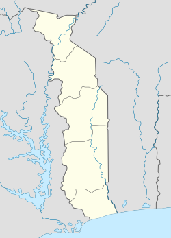
Pagouda
Appearance
Pagouda | |
|---|---|
| Coordinates: 9°45′N 1°19′E / 9.750°N 1.317°E | |
| Country | |
| Region | Kara Region |
| Population (2004) | |
• Total | 13,200 |
Pagouda is a city in Togo with 13,200 inhabitants (2004), near the border of Benin. It is the seat of Binah prefecture in Kara Region.
9°45′N 1°19′E / 9.750°N 1.317°E
Climate
[edit]| Climate data for Pagouda (1991-2020) | |||||||||||||
|---|---|---|---|---|---|---|---|---|---|---|---|---|---|
| Month | Jan | Feb | Mar | Apr | May | Jun | Jul | Aug | Sep | Oct | Nov | Dec | Year |
| Average precipitation mm (inches) | 2.6 (0.10) |
9.9 (0.39) |
32.4 (1.28) |
74.8 (2.94) |
133.7 (5.26) |
181.1 (7.13) |
251.8 (9.91) |
263.4 (10.37) |
252.0 (9.92) |
119.2 (4.69) |
13.3 (0.52) |
0.4 (0.02) |
1,334.6 (52.54) |
| Average precipitation days (≥ 1 mm) | 0.2 | 0.8 | 2.6 | 7.0 | 10.8 | 12.2 | 17.4 | 18.0 | 18.5 | 10.7 | 1.6 | 0.1 | 99.9 |
| Source: NOAA[1] | |||||||||||||
- ^ "Climate Normals 1991–2020". World Meteorological Organization Climatological Standard Normals (1991–2020). National Oceanic and Atmospheric Administration. Retrieved 28 September 2023.

