Outline of Victoria
Appearance
This outline of Victoria is an overview of and topical guide to various aspects of the state of Victoria:

Victoria, commonly abbreviated as Vic, is a state in southeastern Australia. It is the second-smallest state (after Tasmania), with a land area of 227,444 km2 (87,817 sq mi); the second-most-populated state (after New South Wales), with a population of over 6.7 million;[1] and the most densely populated state in Australia (29.5 per km2).[2] Victoria's economy is the second largest among Australian states and is highly diversified, with service sectors predominating.
General reference
[edit]- Pronunciation: /vɪkˈtɔːriə/
- Common English name: Victoria
- Official English name: Victoria
- Postal abbreviation: VIC
- ISO 3166-2 code: AU-VIC
- Nickname(s)
- The Garden State[3]
- The Education State
- Demonym(s): Victorian
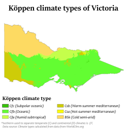
Geography of Victoria
[edit]

- Victoria is: an Australian state, a federated state within Australia
- Population of Victoria: 6,865,400 (2023)[1]
- Area of Victoria: 227,444 km2 (87,817 sq mi)[4]
- Location:
- Time zones:
- Australian Eastern Standard Time (AEST) (UTC+10)
- Summer (DST) Australian Eastern Daylight Time (AEDT) (UTC+11)
Environment
[edit]Regions
[edit]Counties
[edit]- Anglesey
- Benambra
- Bendigo
- Bogong
- Borung
- Bourke
- Buln Buln
- Croajingolong
- Dalhousie
- Dargo
- Delatite
- Dundas
- Evelyn
- Follett
- Gladstone
- Grant
- Grenville
- Gunbower
- Hampden
- Heytesbury
- Kara Kara
- Karkarooc
- Lowan
- Millewa
- Moira
- Mornington
- Normanby
- Polwarth
- Ripon
- Rodney
- Talbot
- Tambo
- Tanjil
- Tatchera
- Villiers
- Weeah
- Wonnangatta
Government and politics of Victoria
[edit]- Form of government: parliamentary democracy constitutional monarchy
- List of elections in Victoria
- Local government areas of Victoria
- Parliament of Victoria
Electoral districts
[edit]- Albert Park
- Ashwood
- Bass
- Bayswater
- Bellarine
- Benambra
- Bendigo East
- Bendigo West
- Bentleigh
- Berwick
- Box Hill
- Brighton
- Broadmeadows
- Brunswick
- Bulleen
- Bundoora
- Carrum
- Caulfield
- Clarinda
- Cranbourne
- Croydon
- Dandenong
- Eildon
- Eltham
- Essendon
- Eureka
- Euroa
- Evelyn
- Footscray
- Frankston
- Geelong
- Gippsland East
- Gippsland South
- Glen Waverley
- Greenvale
- Hastings
- Hawthorn
- Ivanhoe
- Kalkallo
- Ros Spence
- Kew
- Kororoit
- Lara
- Laverton
- Lowan
- Macedon
- Malvern
- Melbourne
- Melton
- Mildura
- Mill Park
- Monbulk
- Mordialloc
- Mornington
- Morwell
- Mulgrave
- Murray Plains
- Narre Warren North
- Narre Warren South
- Nepean
- Niddrie
- Northcote
- Oakleigh
- Ovens Valley
- Pakenham
- Pascoe Vale
- Point Cook
- Polwarth
- Prahran
- Preston
- Richmond
- Ringwood
- Ripon
- Rowville
- Sandringham
- Shepparton
- South Barwon
- South-West Coast
- St Albans
- Sunbury
- Sydenham
- Tarneit
- Thomastown
- Warrandyte
- Wendouree
- Werribee
- Williamstown
- Yan Yean
History of Victoria
[edit]Cities
[edit]Culture of Victoria
[edit]Sports in Victoria
[edit]- Australian rules football in Victoria
- Cricket in Victoria
- Rugby league in Victoria
- Rugby union in Victoria
- Soccer in Victoria
Symbols of Victoria
[edit]
- Coat of arms of Victoria
- Common heath
- Flag of Victoria
- Gold
- Helmeted honeyeater
- Koolasuchus cleelandi
- Leadbeater's possum
- Navy blue
- Weedy seadragon
Economy and Infrastructure of Victoria
[edit]Education in Victoria
[edit]See also
[edit]References
[edit]- ^ a b "National, state and territory population, September 2023 | Australian Bureau of Statistics". Australian Bureau of Statistics. 21 March 2024. Retrieved 10 September 2024.
- ^ The ACT has a higher population density, but it is a territory rather than a state.
- ^ "Victoria, the garden state of Australia". Trove. Retrieved 10 September 2024.
- ^ "Area of Australia - States and Territories". 27 June 2014.
External links
[edit]- Victoria government website
 Wikimedia Atlas of Victoria, Australia
 Victoria travel guide from Wikivoyage


