Oriental (1997–2015)
Appearance
Oriental
الجهة الشرقية | |
|---|---|
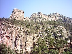
 Jebel Tamejout - Grotte du Chameau (Zegzel) | |
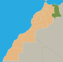
 Location in Morocco | |
| Coordinates: 34°41′N 1°54′W / 34.683°N 1.900°W | |
| Country | |
| Capital | Oujda |
| Government | |
| • Wali (Governor) | Abdelfettah El Houmam |
| Area | |
• Total | 82,900 km2 (32,000 sq mi) |
| Population (2004) | |
• Total | 1,918,094 |
| Time zone | UTC+0 (WET) |
| • Summer (DST) | UTC+1 (WEST) |
Oriental (Arabic: الجهة الشرقية) is one of the sixteen former regions of Morocco. It covers an area of 82,900 km2 and has a population of 1,918,094 (2004 census). The capital and largest city is Oujda, and the second largest city is Nador.
Geography
[edit]It is situated in the north-east of the country, with a northern coastline on the Mediterranean Sea. The regions of Taza-Al Hoceima-Taounate, Fès-Boulemane and Meknès-Tafilalet lie to its west, with the Algerian provinces of Tlemcen and Naâma to its east and Béchar to the south. Melilla, a Spanish autonomous city, also borders the region.
The region is made up into the following prefectures and provinces:
- Berkane Province
- Eddriwesh Province
- Figuig Province
- Jerada Province
- Nador Province
- Prefecture of Oujda-Angad
- Taourirt Province
Municipalities by population (2004)
[edit]
- Oujda, Oujda-Angad: 398,131
- Nador, Nador Province: 124,915
- Taourirt, Taourirt Province: 79,664
- Berkane, Berkane Province: 79,570
- Jerada, Jerada Province: 43,870
- Al Aaroui, Nador Province: 36,021
- El Aioun Sidi Mellouk, Taourirt Province: 34,767
- Beni Ensar, Nador Province: 31,800
- Zaio, Nador Province: 29,851
- Bouarfa, Figuig Province: 24,527
- Sidi Slimane Echcharraa, Berkane Province: 22,889
- Zeghanghane, Nador Province: 20,134
- Ahfir, Berkane Province: 19,477
- Ain Bni Mathar, Jerada Province: 13,526
- Figuig, Figuig Province: 12,516
- Aklim, Berkane Province: 8,979
- Bni Drar, Oujda-Angad: 8,919
- Debdou, Taourirt Province: 4,575
- Touissit, Jerada Province: 3,429
- Saidia, Berkane Province: 3,338
- Ain Erreggada, Berkane Province: 2,975
- Naima, Oujda-Angad: 1,151
References
[edit]- ^ "Recensement général de la population et de l'habitat 2004". Hcp.ma. Retrieved 2012-05-29.
