Oquaga Creek
Appearance
| Oquaga Creek | |
|---|---|
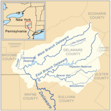
 Delaware Headwaters map showing Oquaga Creek | |
| Location | |
| Country | United States |
| State | New York |
| Counties | Broome, Chenango |
| Physical characteristics | |
| Source | |
| • location | Broome County, New York |
| • coordinates | 42°12′17″N 75°25′19″W / 42.2048042°N 75.4218453°W |
| Mouth | West Branch Delaware River |
• location | Deposit, New York, Broome County, New York, United States |
• coordinates | 42°03′28″N 75°25′22″W / 42.05778°N 75.42278°W[1] |
• elevation | 971 ft (296 m) |
| Basin size | 67.6 sq mi (175 km2) |
| Basin features | |
| Tributaries | |
| • left | Tarbell Brook, Bone Creek |
| • right | Dry Brook, Page Pond Brook, Marsh Creek, Fly Creek |
Oquaga Creek is a river in Broome County and Chenango County in New York. It flows into the West Branch Delaware River by Deposit, New York.[2]
References
[edit]- ^ "Oquaga Creek". Geographic Names Information System. United States Geological Survey, United States Department of the Interior. Retrieved 2018-09-23.
- ^ "oquaga creek". usgs.gov. usgs. 1998. Retrieved 17 May 2017.
data
