Old Auburn Historic District
Appearance
Old Auburn Historic District | |
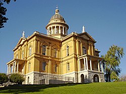
 Auburn California courthouse (1897) | |
| Location | Roughly bounded by Maple, Commercial, Court, Washington, Spring, and Sacramento Streets, Auburn, California, United States |
|---|---|
| Coordinates | 38°53′39″N 121°04′34″W / 38.894167°N 121.076111°W |
| Area | 22 acres (8.9 ha) |
| Built | 1855 |
| NRHP reference No. | 70000138[1] |
| CHISL No. | N62[2] |
| Significant dates | |
| Added to NRHP | December 29, 1970 |
| Designated CHISL | December 29, 1970 |
The Old Auburn Historic District is a historic district in Auburn, California, United States. It is listed as one of the National Register of Historic Places since December 29, 1970.[3][4] It is also known as North Fork Dry Diggings, and Woods Dry Diggings.
History
[edit]The Old Auburn Historic District was the center of commerce during the early California Gold Rush era, with its close proximity to the Gold Country Mother lode.[4] It was one of the earliest mining camps in the state.[4] On April 25, 1851, the city of Auburn was declared the County Seat of Placer County.[4] In the early 1900s, the city became the largest plum producer in the nation, and had a large agricultural industry.[4]
Notable buildings
[edit]- Placer County Courthouse (or Historic Auburn Courthouse, built 1897), 101 Maple Street
- Travellers' Rest and Winery (or Travelers’ Rest Stage Roadhouse, blacksmith shop built c. 1860, and winery c. 1870), 291 Auburn-Folsom Road
- Lawyers Row (built 1855), 299 Commercial Street
- Commercial Street buildings (built 1850s)
- Auburn Joss House (or Chinese Joss House; building built 1930, and shrine built 1860s), 200 Sacramento Street
See also
[edit]References
[edit]- ^ "National Register Information System". National Register of Historic Places. National Park Service. November 2, 2013.
- ^ "Old Auburn Historic Districts". Office of Historic Preservation, California State Parks. Retrieved 2024-08-08.
- ^ "Old Auburn Historic District". NPGallery Digital Asset Management System.
- ^ a b c d e "National Register of Historic Places Inventory/Nomination: Old Auburn Historic District". National Park Service. Retrieved August 8, 2024. With accompanying pictures

