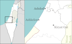
Nir Banim
Appearance
Nir Banim
ניר בנים | |
|---|---|
 | |
| Coordinates: 31°40′20″N 34°45′15″E / 31.67222°N 34.75417°E | |
| Country | Israel |
| District | Southern |
| Council | Be'er Tuvia |
| Affiliation | Moshavim Movement |
| Founded | 1954 |
| Founded by | Sons from other moshavim |
| Population (2022)[1] | 709 |
Nir Banim (Hebrew: נִיר בָּנִים, lit. 'Sons' Meadow') is a moshav in south-central Israel. Located near Kiryat Gat, it falls under the jurisdiction of Be'er Tuvia Regional Council. In 2022 it had a population of 709.[1]
History
[edit]The moshav was founded in 1954 by sons of residents of the moshavim of Be'er Tuvia, Kfar Vitkin, Kfar Yehezkel, Nahalal and Herut. This was also the source of its name.[2] It was established on land that had belonged to the depopulated Palestinian village of al-Sawafir al-Sharqiyya.[3]
Notable people
[edit]References
[edit]- ^ a b "Regional Statistics". Israel Central Bureau of Statistics. Retrieved 21 March 2024.
- ^ Yuval Elʻazari, ed. (2005). Mapa's concise gazetteer of Israel (in Hebrew). Tel-Aviv: Mapa Publishing. p. 35. ISBN 965-7184-34-7.
- ^ Khalidi, Walid (1992), All That Remains: The Palestinian Villages Occupied and Depopulated by Israel in 1948, Washington D.C.: Institute for Palestine Studies, p. 135, ISBN 0-88728-224-5

