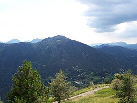
Monte Manos
Appearance
You can help expand this article with text translated from the corresponding article in Italian. (May 2010) Click [show] for important translation instructions.
|
| Monte Manos | |
|---|---|
 | |
| Highest point | |
| Elevation | 1,517 m (4,977 ft) |
| Geography | |
 | |
| Location | Lombardy, Italy |
| Parent range | Brescia and Garda Prealps |
Monte Manos is a mountain of Lombardy, Italy. It has an elevation of 1,517 metres. It administratively belongs to the province of Brescia.
SOIUSA classification
[edit]According to the SOIUSA (International Standardized Mountain Subdivision of the Alps) the mountain can be classified in the following way:[1]
- main part = Eastern Alps
- major sector = Southern Limestone Alps
- section = Brescia and Garda Prealps
- subsection = Prealpi Gardesane
- supergroup = Prealpi Gardesane Sud-occidentali
- group = Gruppo Tombea-Manos
- subgroup = Gruppo della Cima Tombea
- code = II/C-30.II-B.5.a
See also
[edit]References
[edit]- ^ Marazzi, Sergio (2005). Atlante Orografico delle Alpi. SOIUSA (in Italian). Priuli & Verlucca. ISBN 978-88-8068-273-8.
45°48′14″N 10°37′43″E / 45.80389°N 10.62861°E
