Mont Brome
Appearance
| Mont Brome | |
|---|---|
 | |
| Highest point | |
| Elevation | 553 m (1,814 ft)[1] |
| Listing | Mountains of Canada |
| Coordinates | 45°17′21″N 72°38′16″W / 45.28917°N 72.63778°W[2] |
| Geography | |
| Parent range | Monteregian Hills |
| Topo map | NTS 31H7 Granby[2] |
| Geology | |
| Rock age | Early Cretaceous |
| Mountain type | Intrusive stock |
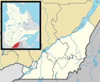
Mont Brome (aka Bromont, Bromount, Mount Brome) is part of the Monteregian Hills in southern Quebec. Its summit stands 553 m (1,814 ft) above sea level. It is near the town of Bromont, Quebec. The ski resort Ski Bromont lies on its slopes.
Geology
[edit]Mont Brome might be the deep extension of a vastly eroded ancient volcanic complex, which was probably active about 125 million years ago.[3] The mountain was created when the North American Plate moved westward over the New England hotspot,[3] along with other mountains of the Monteregian Hills that form part of the vast Great Meteor hotspot track.
See also
[edit]References
[edit]- ^ "Mont Brome". Bivouac.com. Retrieved 2010-03-13.
- ^ a b "Mont Brome". Geographical Names Data Base. Natural Resources Canada. Retrieved 2025-01-24.
- ^ a b Scheirer, Dan. "A Hundred-Million Year History of the Corner Rise and New England Seamounts". NOAA. Archived from the original on 2006-05-03. Retrieved 2007-08-01.

