
Middleburg Historic District (Middleburg, Florida)
Middleburg Historic District | |
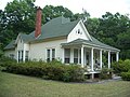
 Side view of the home of George Randolph Frisbee, Jr. | |
  | |
| Location | Middleburg, Florida |
|---|---|
| Coordinates | 30°4′9″N 81°51′36″W / 30.06917°N 81.86000°W |
| Area | 60 acres (240,000 m2) |
| MPS | Middleburg MPS |
| NRHP reference No. | 90000313[1] |
| Added to NRHP | March 9, 1990 |
The Middleburg Historic District is a U.S. historic district designated as such on March 9th, 1990 and located near Black Creek in Middleburg, Florida.[2]
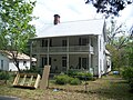
The Middleburg Historic District encompasses five historic buildings, a historical marker briefly describing the area's history, and a commemorative plaque pertinent to Middleburg's role in the American Civil War:
- Clark-Chalker House at 3891 Main Street
- Haskell-Long House on Main Street, 3858 Main Street
- Frosard W. Budington House, 3816 Main Street
- George Randolph Frisbee Jr. House, 2125 Palmetto Street
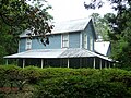
- Edinfield House, 2145 Wharf Street (previously Thompson Street)
History
[edit]The Federal Road
[edit]The Federal Road, sometimes called "the military road," was constructed between 1824–1827, and provided access to Fort Heileman during the Second Seminole War, spanning Colerain, Georgia to Tampa, traversing the villages of Garey's Ferry and Whitesville, as well as providing military infrastructure and increasing development and settlement in the area. Garey's Ferry and Whitesville were distinct towns at the time, the former along the north fork of Black Creek and the latter along the south fork.
The Middleburg Historic District is located in the village formerly called Garey's Ferry, and the two villages consolidated into Middleburgh [sic] in 1851. Garey's Ferry was the location of Forts Heileman (1835&ndash1842) and Sanderson (July 1840).[3]
The Federal Road was one of several roads funded by the U.S. federal government within Florida in the 1820s and should not be confused with the Bellamy Road or a separate so-called "federal road" which connected Pensacola to Saint Augustine.
American Civil War
[edit]On October 23, 1864, during the American Civil War, the 4th Massachusetts Volunteer Cavalry engaged local Confederates in a skirmish from their base at the Magnolia Springs hotel. Moving into Middleburg the next day, October 24, 1864, the 4th Massachusetts raided and set fire to downtown Middleburg on Main Street and Thompson (now Wharf) Street, destroying Samuel B. Thompson's cotton warehouses and docks, as well as a hotel. The 2nd Florida Cavalry, under command of Captain J.J. Dickison, retaliated by firing on the Massachusetts regiment, leading the latter to retreat across Black Creek and burn the ferry bridge behind them. As the Massachusetts regiment rushed back to Magnolia Springs, Dickison's regiment detoured four miles through Whitesville[4] and caught the Massachusetts regiment at Jeremiah Halsey's Plantation, engaging in a skirmish that resulted in twelve Union deaths and Confederate victory. This skirmish is known officially as the Battle of Halsey's Plantation,[5] but has also been referred to as the Battle of Big Gum Creek.[6] The exact location of Halsey's Plantation is not known, but it was near the site that is currently Shadowlawn Elementary School on County Road 218.
Among the repeated skirmishes between the 4th Massachusetts and 2nd Florida cavalries was a two-hour engagement whereby Dickison's troops rescued cattle that had been seized by Union troops, which local history refers to as the Battle of the Tiger Head.[7]

Other historic communities
[edit]Whitesville
[edit]Before Middleburg was consolidated into its current town limits, the area comprised two distinct settlements upon each prong of Black Creek, within miles of each other. Garey's Ferry, located upon the North Prong of Black Creek, was situated upon Main Street, near the site of the former Fort Heilman, and currently the site of the Main Street Boat Ramp, Memorial Park, and the physical Historic District.
Situated on the South Prong of Black Creek was the settlement of Whitesville (briefly called "Webster"), which was begun by Ozias Budington, and was located south of the intersection of SR21 (Blanding Blvd.) and CR218, in what is today the Black Creek Park North neighborhood. No buildings from the original Whitesville settlement remain, but the Budington cemetery is located on private land on Halperns Way, while other named streets in the community (e.g. Whitesville Landing Court, Budington Drive) allude to the village that once existed there.
Hill Top
[edit]Hill Top is another historic community located in Middleburg. The site of Middleburg's historic black community, Hill Top was first settled by homesteaders, including Grant Forman (1868-1951), in the 1890s. Today, the community is situated around Forman Circle, and includes churches, homes, and a one-room schoolhouse[8] According to "Embedded in Clay," Forman fled to South Carolina after his house was burned by a white mob. Frosard Budington, a leader of Whitesville, covered the cost of Forman's land taxes until such time as it was safe for Forman to return to Hill Top.
Gallery of Historic Homes
[edit]-

-
-
-
-
 The "Edinfield" House is the only home located on Wharf Street


References
[edit]- ^ "National Register Information System". National Register of Historic Places. National Park Service. July 9, 2010.
- ^ Stephen A. Olausen; Barbara E. Mattick (January 1990). "National Register of Historic Places Registration: George A. Chalker House / Edinfield House". National Park Service. Retrieved March 24, 2018. With seven photos.
- ^ "Journal of the Military Service Institution of the United States". 1910.
- ^ "Union soldier's battle career lasted only 10 months in Clay County".
- ^ "Calendar of Civil War Activity". archives.clayclerk.com. archives.clayclerk.com. Retrieved July 5, 2014.
- ^ http://ufdcimages.uflib.ufl.edu/UF/00/02/84/16/00383/02-02-2012.pdf Includes reference to "Battle of Big Gum Creek."
- ^ "Archived copy". Archived from the original on October 20, 2021. Retrieved October 20, 2021.
{{cite web}}: CS1 maint: archived copy as title (link) - ^ "Hill Top struggles to survive amid Clay County changes".