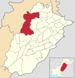
Mianwali Division
Mianwali Division
میانوالی ڈویژن | |
|---|---|
 Location of Mianwali Division in Punjab | |
| Coordinates: 32°10′N 72°30′E / 32.167°N 72.500°E | |
| Country | |
| Province | |
| Capital | Mianwali |
| Established | proposed 14 January 2023 |
| Split from | Sargodha Division Rawalpindi Division |
| Districts | 3 |
| Government | |
| • Type | Divisional Administration |
| • Commissioner | N/A |
| • Regional Police Officer | N/A |
| Elevation | 155 m (509 ft) |
| Population | |
| • Urban | N/A |
| • Rural | N/A |
| Time zone | UTC+5 (PST) |
| Dialling code | 0459 (Mianwalli), 0453 (Bhakkar), 04(Talagang) |
Mianwali Division is a proposed administrative division of Punjab province, Pakistan. Mianwali city would be the capital of the division.[1] As of 2024, the division has not been established.[2]
On January 14, 2023, CM Pervaiz Elahi announced that Mianwali and Bhakkar districts upgraded to divisional status, carved from the Sargodha Division. Newly formed Talagang district from the northern Rawalpindi Division would also be part of the division.[3][4] However, the Election Commission of Pakistan barred the Punjab government from issuing the notification of granting the status of division to Mianwali, as it was conducting delimitation for by-polls in the province, the line of demarcation could not be drawn at the time.[3]
List of the Districts
[edit]| # | District | Headquarter | Area
(km²)[5] |
Pop.
(2023) |
Density
(ppl/km²) (2023) |
Lit. rate
(2023) |
|---|---|---|---|---|---|---|
| 1 | Mianwali | Mianwali | 5,840 | 1,798,268 | 307.4 | 62.87% |
| 2 | Bhakkar | Bhakkar | 8,153 | 1,957,470 | 240.5 | 55.68% |
| 3 | Talagang | Talagang | 2,932 | 602,246 | 205.06 | N/A |
| Mianwali Division | 16,925 | 4,357,984 | 257.36 | N/A | ||
List of the Tehsils
[edit]| # | Tehsil | Area
(km²)[6] |
Pop.
(2023) |
Density
(ppl/km²) (2023) |
Lit. rate
(2023) |
Districts |
|---|---|---|---|---|---|---|
| 1 | Bhakkar | 2,427 | 809,789 | 333.66 | 58.56% | Bhakkar District |
| 2 | Darya Khan | 1,719 | 421,309 | 245.09 | 51.09% | |
| 3 | Kaloorkot | 2,239 | 415,708 | 185.67 | 55.43% | |
| 4 | Mankera | 1,768 | 310,664 | 175.71 | 54.83% | |
| 5 | Isakhel | 1,863 | 414,100 | 222.28 | 55.02% | Mianwali District |
| 6 | Mianwali | 2,689 | 908,405 | 337.82 | 66.09% | |
| 7 | Piplan | 1,288 | 475,763 | 369.38 | 63.46% | |
| 8 | Talagang | 2,022 | 457,635 | 226.33 | 75.63% | Talagang District |
| 9 | Lawa | 910 | 144,611 | 158.91 | 71.37% | |
| 10 | Multan Khurd | N/A | N/A | N/A | N/A |
References
[edit]- ^ "Southern Punjab and the issue of equality". DAWN.COM. 2023-06-15. Retrieved 2024-07-24.
- ^ Punjab Portal: Division and Districts
- ^ a b Reporter, News (14 January 2023). "ECP bars Punjab gov from notifying Mianwali as division". Duniya News. p. 1. Retrieved 14 January 2023.
- ^ Malik, Mansoor (January 15, 2023). "Punjab cabinet approves upgrade of Mianwali as division". Dawn News. p. 1. Retrieved January 15, 2023.
- ^ "TABLE 1 : AREA, POPULATION BY SEX, SEX RATIO, POPULATION DENSITY, URBAN POPULATION, HOUSEHOLD SIZE AND ANNUAL GROWTH RATE, CENSUS-2023, PUNJAB" (PDF).
- ^ "TABLE 1 : AREA, POPULATION BY SEX, SEX RATIO, POPULATION DENSITY, URBAN POPULATION, HOUSEHOLD SIZE AND ANNUAL GROWTH RATE, CENSUS-2023, PUNJAB" (PDF).
