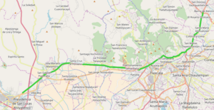
Mexican Federal Highway 117D
Appearance
| Federal Highway 117D | |
|---|---|
| Carretera federal 117D | |
 | |
| Route information | |
| Maintained by Promotora y Operadora de Infraestructura S.A. de C.V. | |
| Autopista San Martín Texmelucan-Tlaxcala | |
| Length | 35.2 km[1] (21.9 mi) |
| North end | |
| Major intersections | |
| South end | |
| Libramiento de Tlaxcala | |
| Length | 11 km[1] (6.8 mi) |
| West end | |
| Major intersections | |
| East end | |
| Location | |
| Country | Mexico |
| Highway system | |
Federal Highway 117D is the designation for two toll highways in eastern Mexico.
San Martín Texmelucan-Tlaxcala-El Molinito
[edit]The first of the two roads connects San Martín Texmelucan, Puebla to El Molinito, northeast of Tlaxcala City and southwest of Apizaco. The road is operated by Promotora y Operadora de Infraestructura S.A. de C.V. (PINFRA). A toll of 63 pesos per car is charged to travel between Texmelucan and Tlaxcala.[2]
Libramiento de Tlaxcala
[edit]
The 11 kilometres (6.8 mi) Libramiento de Tlaxcala serves as a southern bypass of the city, connecting the highway to Texmelucan, the state toll road between Puebla and Tlaxcala, and Mexican Federal Highway 121. It was inaugurated on March 27, 2015.[3] The bypass's construction began in 2009, with three kilometers remaining unfinished from 2012 to 2015.[4]
References
[edit]- ^ a b Datos Viales - Tlaxcala, SCT, 2017
- ^ SCT - Tarifas Vigentes, as of July 1, 2016
- ^ "Inauguran EPN y MGZ Libramiento Tlaxcala y la autopista concesionada a Puebla". Diario Marca. 27 March 2015. Retrieved 11 April 2017.
- ^ Ávila, Eduardo (26 March 2015). "Peña Nieto inaugura hoy Libramiento Tlaxcala con 6 años de retraso". La Polilla. Retrieved 11 April 2017.

