Mesopotamia, Oxford


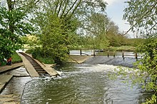
Mesopotamia is a narrow ait (about 800 yards by 30 yards) that forms part of the University Parks in Oxford, England.[1] It lies between the upper and lower levels of the River Cherwell which are partly interspersed with the Thames.[citation needed] The name Mesopotamia in Greek means "between the rivers", and is shared with an area between the Tigris and Euphrates rivers in present-day Iraq.
The land was purchased by the University of Oxford during the expansion of the Oxford University Parks between 1860 and 1865. A footpath, Mesopotamia Walk, laid out in 1865 runs along the centre of the spur to Kings Mill.[2]
The Domesday Book records a watermill on this site and milling continued until 1825; one level of the river was once the mill stream.[3] From 1914, attempts were made to introduce wild ducks and geese to the area, which proved fruitless due to a predatory otter population. Until 1926, a ferry operated from a point halfway along the Walk, when it was replaced by a footbridge.
Position: grid reference SP525069
See also
[edit]References
[edit]- ^ Hibbert, Christopher, ed. (1988). "Mesopotamia". The Encyclopaedia of Oxford. Macmillan. pp. 256–257. ISBN 0-333-39917-X.
- ^ "Introduction to The University Parks". University of Oxford. Retrieved 25 September 2012.
- ^ "Origin of the site". University Parks: A Historical Guide. University of Oxford. Retrieved 25 September 2012.
