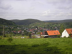
Möhrenbach
Appearance
Möhrenbach | |
|---|---|
 Möhrenbach | |
| Coordinates: 50°37′24″N 10°59′41″E / 50.62333°N 10.99472°E | |
| Country | Germany |
| State | Thuringia |
| District | Ilm-Kreis |
| Municipality | Gehren |
| Area | |
• Total | 13.86 km2 (5.35 sq mi) |
| Elevation | 540 m (1,770 ft) |
| Population (2012-12-31) | |
• Total | 654[1] |
| Time zone | UTC+01:00 (CET) |
| • Summer (DST) | UTC+02:00 (CEST) |
| Postal codes | 98708 |
| Dialling codes | 036783 |
| Vehicle registration | IK |
| Website | Möhrenbach |
Möhrenbach is a village and a former municipality in the district Ilm-Kreis, in Thuringia, Germany. Since 31 December 2013, it is part of the municipality Gehren.[2]
Möhrenbach dates back as far as 1374 as a mining town in the County of Schwarzburg under the jurisdiction of feudal lords. The town has been known to provide copper, silver, and lead, as well as later mentions of porcelain goods and woodworking. From 1533 to 1920, the village belonged to the district Schwarzburg-Sondershausen, then to the district Arnstadt until 1944. Historic sights in Möhrenbach include the bell tower, World War 1 memorial, and a house dating back to 1606. Today residents enjoy hunting, hiking, and mountain running.[3]
References
[edit]- ^ "Thüringer Landesamt für Statistik" (in German). Retrieved 28 February 2024.
- ^ "Gebietsänderungen vom 01. Januar bis 31. Dezember 2013". Statistisches Bundesamt (in German). 23 November 2023. Retrieved 28 February 2024.
- ^ "Möhrenbach, Germany". Ilmenau himmelblau. Retrieved December 9, 2024.


