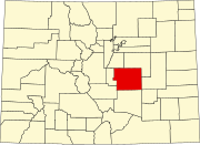
Lytle, Colorado
Appearance

Lytle is a ghost town located 12 miles south-west of Fountain in El Paso County, Colorado. The only building that remains is the Lytle School.[1] The earlier name of the town was Turkey Creek. There was a Post Office from 1877 to 1881 and a Rural Post Office from 1885 to 1920.[2]
See also
[edit]References
[edit]- ^ Keroher, Grace C. (1966). Lexicon of geologic names of the United States for 1936-1960. Vol. Part 2. U.S. Govt. Print. Off. p. 2287.
- ^ "Place Names of Colorado" (PDF). Denver Public Library. pp. 390, 647. Retrieved July 19, 2018.
38°36′09″N 104°52′04″W / 38.60250°N 104.86778°W

