Loughnavalley
Appearance
Loughnavalley
Lochán an Bhealaigh | |
|---|---|
Village | |
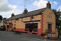
 Fox's bar and grocery shop, Louaghnavalley | |
| Coordinates: 53°29′10″N 7°31′35″W / 53.4860°N 7.5265°W | |
| Country | Ireland |
| Province | Leinster |
| County | County Westmeath |
| Time zone | UTC+0 (WET) |
| • Summer (DST) | UTC-1 (IST (WEST)) |
Louaghnavalley or Loughnavally (Irish: Lochán an Bhealaigh)[1] is a village in County Westmeath, Ireland. It is located at the crossroads of the R389 and the R390, to the west of Mullingar.[2][3]
The Hill of Uisneach stands to the west of the town, near the village of Killare.[4]
The village contains a Roman Catholic church, the Church of the Assumption, a national school and a bar.
Sport
[edit]Loughnavalley GAA is a Gaelic football club that competes at Junior grade. The club was established in 1976 and its grounds are 2 km (1.2 mi) from the Hill of Uisneach. The club's underage teams are amalgamated with Castletown Geoghegan to form Lilliput Gaels.[5]
See also
[edit]References
[edit]- ^ "Lochán an Bhealaigh / Loughanavally". logainm.ie. Placenames Database of Ireland. Retrieved 7 July 2022.
- ^ Parliament, Great Britain (1892). The Parliamentary Debates. R. Bagshaw.
- ^ Dáil, Ireland Oireachtas (1929). Parliamentary debates; official report.
- ^ "Loughnavalley, Mullingar, Co. Westmeath". Find Latitude and Longitude. Retrieved 2 July 2020.
- ^ "Team". Loughnavalley GAA. Retrieved 20 January 2025.


