Liérganes
Appearance
Liérganes | |
|---|---|
 Aerial view of Liérganes | |
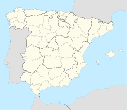
 Location of Liérganes | |
| Coordinates: 43°20′36″N 3°44′28″W / 43.34333°N 3.74111°W | |
| Country | |
| Autonomous community | |
| Province | Cantabria |
| Comarca | Pas and Miera valleys |
| Judicial district | Medio Cudeyo |
| Capital | Liérganes |
| Government | |
| • Alcalde | Santiago Rego Rodríguez (2015) (ULP) |
| Area | |
• Total | 36.73 km2 (14.18 sq mi) |
| Elevation | 110 m (360 ft) |
| Population (2018)[1] | |
• Total | 2,370 |
| • Density | 65/km2 (170/sq mi) |
| Demonym(s) | Lierganés, sa |
| Time zone | UTC+1 (CET) |
| • Summer (DST) | UTC+2 (CEST) |
| Website | Official website |
Liérganes is a municipality and a locality located in the autonomous community of Cantabria, Spain.[2] It is bordered in the north by Medio Cudeyo, in the east by Riotuerto, in the south by Miera and in the west by Penagos. The river Miera flows through the village, supplying the spas of Liérganes. It has a rail link which links it to Santander. According to the 2007 census, the city has a population of 2,391 inhabitants. It has been named one of the most beautiful villages in Spain.
Towns
[edit]- Bucarrero
- Calgar
- Casa del Monte
- El Condado
- La Costera
- Extremera
- La Herrán
- Liérganes (capital)
- El Mercadillo
- Las Porquerizas
- Los Prados
- La Quieva
- La Rañada
- El Rellano
- Rubalcaba
- La Vega
- Pámanes
- Somarriba
- Tarriba
References
[edit]- ^ Municipal Register of Spain 2018. National Statistics Institute.
- ^ "Liérganes". Cantabria 102 Municipios (in Spanish). Archived from the original on 21 September 2019. Retrieved 9 April 2020.


